Traill County, North Dakota
Traill County is a county in the U.S. state of North Dakota. As of the 2010 United States Census listed the population at 8,121.[1] Its county seat is Hillsboro,[2] and its largest city is Mayville.
Traill County | |
|---|---|
 | |
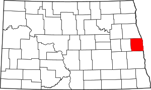 Location within the U.S. state of North Dakota | |
 North Dakota's location within the U.S. | |
| Coordinates: 47°27′N 97°11′W | |
| Country | |
| State | |
| Founded | January 12, 1875 (created) February 23, 1875 (organized) |
| Named for | Walter John Strickland Traill |
| Seat | Hillsboro |
| Largest city | Mayville |
| Area | |
| • Total | 863 sq mi (2,240 km2) |
| • Land | 862 sq mi (2,230 km2) |
| • Water | 0.6 sq mi (2 km2) 0.07% |
| Population (2010) | |
| • Total | 8,121 |
| • Estimate (2019) | 8,036 |
| • Density | 9.4/sq mi (3.6/km2) |
| Time zone | UTC−6 (Central) |
| • Summer (DST) | UTC−5 (CDT) |
| Congressional district | At-large |
| Website | http://www.co.traill.nd.us |
History
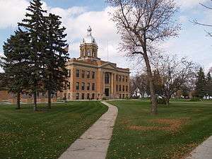
The Dakota Territory legislature created the county on January 12, 1875, with areas partitioned from Burbank (now Barnes), Cass, and Grand Forks counties. It was named for Walter John Strickland Traill, an employee of the Hudson's Bay Company and son of Canadian pioneer Catharine Parr Traill.[3] The first county building was a small single-story building in Caledonia. Several replacement courthouses were built during the late 19th century and several votes to move the county seat to Mayville narrowly failed. Efforts to move the county seat to Hillsboro were more successful, and all county records were moved there in 1890.[4] Construction of the current county building began in 1905; it is now listed on the National Register of Historic Places.[5]
The county boundaries were altered in 1881 and in 1883. It has maintained its current configuration since 1883.[3][6]
Geography
Traill County lies on the east side of North Dakota. Its east boundary line abuts the west boundary line of the state of Minnesota (across the Red River). The Goose River flows eastward through the center of the county to discharge into the Red. The northward-flowing Red River forms the eastern boundary line of the county on its way to the Hudson Bay, and the Elk River flows south-southeastward through the SW part of the county. The county terrain consists of rolling hills, devoted to agriculture.[7] The terrain slopes to the east and north, with its highest point on the lower western boundary line, at 1,201' (366m) ASL.[8] The county has a total area of 863 square miles (2,240 km2), of which 862 square miles (2,230 km2) is land and 0.6 square miles (1.6 km2) (0.07%) is water.[9]
Major highways
Airports
Adjacent counties
- Grand Forks County - north
- Polk County, Minnesota - northeast
- Norman County, Minnesota - east
- Cass County - south
- Steele County - west
Demographics
| Historical population | |||
|---|---|---|---|
| Census | Pop. | %± | |
| 1880 | 4,123 | — | |
| 1890 | 10,217 | 147.8% | |
| 1900 | 13,107 | 28.3% | |
| 1910 | 12,545 | −4.3% | |
| 1920 | 12,210 | −2.7% | |
| 1930 | 12,600 | 3.2% | |
| 1940 | 12,300 | −2.4% | |
| 1950 | 11,359 | −7.7% | |
| 1960 | 10,583 | −6.8% | |
| 1970 | 9,571 | −9.6% | |
| 1980 | 9,624 | 0.6% | |
| 1990 | 8,752 | −9.1% | |
| 2000 | 8,477 | −3.1% | |
| 2010 | 8,121 | −4.2% | |
| Est. 2019 | 8,036 | [10] | −1.0% |
| US Decennial Census[11] 1790-1960[12] 1900-1990[13] 1990-2000[14] 2010-2019[1] | |||
2000 census
As of the 2000 United States Census, there were 8,477 people, 3,341 households, and 2,231 families in the county. The population density was 9.83/sqmi (3.80/km²). There were 3,708 housing units at an average density of 4.30/sqmi 1.66/km²). The racial makeup of the county was 97.31% White, 0.11% Black or African American, 0.94% Native American, 0.15% Asian, 0.01% Pacific Islander, 0.96% from other races, and 0.52% from two or more races. 2.18% of the population were Hispanic or Latino of any race. 58.9% were of Norwegian and 20.6% German ancestry.
There were 3,341 households out of which 30.9% had children under the age of 18 living with them, 58.0% were married couples living together, 5.4% had a female householder with no husband present, and 33.2% were non-families. 29.3% of all households were made up of individuals and 15.10% had someone living alone who was 65 years of age or older. The average household size was 2.41 and the average family size was 3.00.
The county population contained 24.8% under the age of 18, 9.7% from 18 to 24, 24.8% from 25 to 44, 21.6% from 45 to 64, and 19.1% who were 65 years of age or older. The median age was 39 years. For every 100 females there were 100.8 males. For every 100 females age 18 and over, there were 97.9 males.
The median income for a household in the county was $37,445, and the median income for a family was $45,852. Males had a median income of $30,138 versus $20,583 for females. The per capita income for the county was $18,014. About 6.4% of families and 9.2% of the population were below the poverty line, including 9.6% of those under age 18 and 8.1% of those age 65 or over.
2010 census
As of the 2010 United States Census, there were 8,121 people, 3,394 households, and 2,150 families in the county.[15] The population density was 9.42/sqmi (3.71/km²). There were 3,780 housing units at an average density of 4.39/sqmi (1.73/km²).[16] The racial makeup of the county was 96.2% white, 0.8% American Indian, 0.5% black or African American, 0.3% Asian, 1.1% from other races, and 1.2% from two or more races. Those of Hispanic or Latino origin made up 2.6% of the population.[15] In terms of ancestry, 53.2% were Norwegian, 38.1% were German, 5.9% were Irish, and 2.6% were American.[17]
Of the 3,394 households, 27.6% had children under the age of 18 living with them, 54.2% were married couples living together, 6.2% had a female householder with no husband present, 36.7% were non-families, and 31.3% of all households were made up of individuals. The average household size was 2.29 and the average family size was 2.88. The median age was 42.6 years.[15]
The median income for a household in the county was $44,290 and the median income for a family was $60,054. Males had a median income of $39,846 versus $28,378 for females. The per capita income for the county was $23,340. About 4.6% of families and 9.2% of the population were below the poverty line, including 10.9% of those under age 18 and 11.1% of those age 65 or over.[18]
Communities

Cities
Unincorporated communities
Townships
- Belmont
- Bingham
- Blanchard
- Bloomfield
- Bohnsack
- Buxton
- Caledonia
- Eldorado
- Elm River
- Ervin
- Galesburg
- Garfield
- Greenfield
- Herberg
- Hillsboro
- Kelso
- Lindaas
- Mayville
- Morgan
- Norman
- Norway
- Roseville
- Stavanger
- Viking
- Wold
Politics
Traill County voters lean Republican. In only two national elections since 1964 has the county selected the Democratic Party candidate.
| Year | Republican | Democratic | Third parties |
|---|---|---|---|
| 2016 | 57.6% 2,265 | 31.6% 1,241 | 10.9% 427 |
| 2012 | 50.9% 1,996 | 46.2% 1,811 | 2.9% 114 |
| 2008 | 45.7% 1,845 | 52.9% 2,136 | 1.5% 60 |
| 2004 | 59.9% 2,543 | 38.9% 1,651 | 1.3% 54 |
| 2000 | 58.2% 2,392 | 36.8% 1,512 | 5.1% 208 |
| 1996 | 45.0% 1,820 | 45.1% 1,822 | 9.9% 400 |
| 1992 | 44.3% 2,019 | 36.0% 1,638 | 19.7% 896 |
| 1988 | 56.2% 2,562 | 42.6% 1,940 | 1.3% 57 |
| 1984 | 64.7% 3,037 | 33.7% 1,580 | 1.6% 77 |
| 1980 | 60.9% 3,092 | 28.1% 1,428 | 11.0% 556 |
| 1976 | 53.3% 2,800 | 44.8% 2,352 | 1.9% 99 |
| 1972 | 61.4% 3,118 | 37.3% 1,892 | 1.3% 68 |
| 1968 | 57.6% 2,692 | 37.2% 1,740 | 5.3% 246 |
| 1964 | 46.9% 2,312 | 53.0% 2,614 | 0.1% 3 |
| 1960 | 60.7% 3,218 | 39.3% 2,084 | 0.0% 1 |
| 1956 | 61.0% 3,090 | 38.9% 1,969 | 0.1% 3 |
| 1952 | 72.1% 3,884 | 27.5% 1,484 | 0.4% 23 |
| 1948 | 52.0% 2,328 | 41.9% 1,874 | 6.2% 275 |
| 1944 | 48.7% 2,370 | 50.9% 2,479 | 0.4% 20 |
| 1940 | 53.5% 2,882 | 45.9% 2,476 | 0.6% 32 |
| 1936 | 34.3% 1,807 | 52.8% 2,780 | 12.9% 682 |
| 1932 | 37.3% 1,893 | 61.3% 3,112 | 1.4% 69 |
| 1928 | 71.4% 3,638 | 28.4% 1,447 | 0.3% 13 |
| 1924 | 56.6% 2,596 | 5.1% 234 | 38.3% 1,753 |
| 1920 | 86.0% 3,666 | 12.3% 523 | 1.7% 74 |
| 1916 | 64.6% 1,423 | 30.2% 664 | 5.2% 115 |
| 1912 | 21.1% 365 | 29.2% 507 | 49.7% 862 |
| 1908 | 66.0% 1,207 | 26.8% 490 | 7.2% 131 |
| 1904 | 83.0% 1,566 | 9.3% 176 | 7.7% 145 |
| 1900 | 76.1% 1,537 | 20.3% 409 | 3.6% 73 |
Notes
- "State & County QuickFacts". United States Census Bureau. Retrieved November 1, 2013.
- "Find a County". National Association of Counties. Retrieved June 7, 2011.
- "County History". North Dakota.gov. The State of North Dakota. Archived from the original on February 2, 2015. Retrieved February 4, 2015.
- "Traill County, North Dakota". Retrieved January 30, 2012.
- "National Register Information System". National Register of Historic Places. National Park Service. July 9, 2010.
- "Dakota Territory, South Dakota, and North Dakota: Individual County Chronologies". Dakota Territory Atlas of Historical County Boundaries. The Newberry Library. 2006. Retrieved February 24, 2019.
- Traill County ND Google Maps (accessed 24 February 2019)
- ""Find an Altitude/Traill County ND" Google Maps (accessed 24 February 2019)". Archived from the original on May 21, 2019. Retrieved February 24, 2019.
- "2010 Census Gazetteer Files". US Census Bureau. August 22, 2012. Archived from the original on January 29, 2015. Retrieved February 1, 2015.
- "Population and Housing Unit Estimates". Retrieved April 2, 2020.
- "US Decennial Census". US Census Bureau. Retrieved February 1, 2015.
- "Historical Census Browser". University of Virginia Library. Retrieved February 1, 2015.
- Forstall, Richard L., ed. (April 20, 1995). "Population of Counties by Decennial Census: 1900 to 1990". US Census Bureau. Retrieved February 1, 2015.
- "Census 2000 PHC-T-4. Ranking Tables for Counties: 1990 and 2000" (PDF). US Census Bureau. April 2, 2001. Retrieved February 1, 2015.
- "Profile of General Population and Housing Characteristics: 2010 Demographic Profile Data". US Census Bureau. Archived from the original on February 13, 2020. Retrieved April 3, 2016.
- "Population, Housing Units, Area, and Density: 2010 - County". US Census Bureau. Archived from the original on February 13, 2020. Retrieved April 3, 2016.
- "Selected Social Characteristics in the US – 2006-2010 American Community Survey 5-Year Estimates". US Census Bureau. Archived from the original on February 13, 2020. Retrieved April 3, 2016.
- "Selected Economic Characteristics – 2006-2010 American Community Survey 5-Year Estimates". US Census Bureau. Archived from the original on February 13, 2020. Retrieved April 3, 2016.
- Leip, David. "Atlas of US Presidential Elections". uselectionatlas.org. Retrieved April 13, 2018.
External links
- Traill County official website
- Traill County Economic Development Commission website
- Centennial of Traill County, 1875-1975 from the Digital Horizons website
- Traill County map, North Dakota DOT
Places adjacent to Traill County, North Dakota | ||||||||||
|---|---|---|---|---|---|---|---|---|---|---|
| ||||||||||
Municipalities and communities of Traill County, North Dakota, United States | ||
|---|---|---|
| Cities | Map of North Dakota highlighting Traill County | |
| CDPs | ||
| Unincorporated communities | ||
| Footnotes | ‡This populated place also has portions in an adjacent county or counties | |

| Authority control |
|
|---|