Wauwatosa, Wisconsin
| Wauwatosa, Wisconsin | |
|---|---|
| City | |
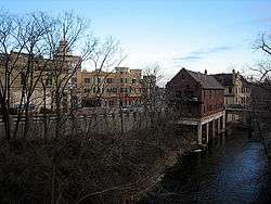 Wauwatosa along the banks of the Menomonee River | |
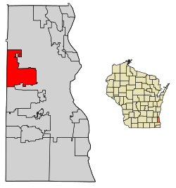 Location of Wauwatosa in Milwaukee County, Wisconsin. | |
| Coordinates: 43°4′N 88°2′W / 43.067°N 88.033°WCoordinates: 43°4′N 88°2′W / 43.067°N 88.033°W | |
| Country | United States |
| State | Wisconsin |
| County | Milwaukee |
| Government | |
| • Mayor | Kathy Ehley |
| • Congressional Rep. | Jim Sensenbrenner (R) |
| Area[1][2] | |
| • City | 13.25 sq mi (34.32 km2) |
| • Land | 13.25 sq mi (34.32 km2) |
| • Water | 0 sq mi (0 km2) 0% |
| Elevation | 673 ft (205 m) |
| Population (2010)[3] | |
| • City | 46,396 |
| • Estimate (2017)[4] | 48,277 |
| • Density | 3,501.6/sq mi (1,352.0/km2) |
| • Metro | 1,753,355 (Milwaukee) |
| Time zone | UTC−6 (Central) |
| • Summer (DST) | UTC−5 (CDT) |
| Area code(s) | 414 |
| FIPS code | 55-84675[5] |
| GNIS feature ID | 1576335[6] |
| Website |
www |
Wauwatosa (originally Wau-wau-too-sa or Hart's Mill) is a city in Milwaukee County, Wisconsin, United States. The population was 46,396 at the 2010 census. Wauwatosa is located immediately west of Milwaukee, and is a part of the Milwaukee metropolitan area. It is named after the Potawatomi word for firefly.[7]
History
The lush Menomonee Valley of the Wauwatosa area provided a key overland gateway between the rich glacial farmland of southeastern Wisconsin and the Port of Milwaukee. In 1835, Charles Hart became the first Euro-American to settle here, followed that year by 17 other families. The following year a United States Road was built from Milwaukee through Wauwatosa, eventually reaching Madison. Charles Hart built a mill in 1845 on the Menomonee River which gave the settlement its original name of "Hart's Mill." The mill was torn down in 1914.[8]
The Town of Wau-wau-too-sa was created by act of the Wisconsin Territorial Legislature on April 30, 1840. As of the 1840 census, the population of the Town of Wau-wau-too-sa or Wauwatosa was 342.[9] The town government was organized in 1842. The town's borders originally extended from the present-day Greenfield Avenue in the south to Hampton Avenue in the north, and from 27th Street in the east to the Waukesha County line in the west, encompassing sections of present-day Milwaukee, West Milwaukee and West Allis, plus the southern part of former North Milwaukee, which was wholly annexed into the city of Milwaukee in 1927. Most of the town was farmland through the remainder of the 19th century.
In 1849 the Watertown Plank Road was constructed through Wauwatosa, mainly following the old Madison territorial road. In 1851 Wisconsin's first railroad (later The Milwaukee Road) established Wauwatosa as its western terminus. The Village of Wauwatosa was incorporated from the central part of the Town of Wauwatosa in 1892, and was rechartered as the City of Wauwatosa on May 27, 1897.[10]
On November 25, 1952, the City of Wauwatosa more than doubled its size by annexing 8.5 square miles (22 square kilometers) of land west of the Menomonee River, the entire remaining portion of the Town of Wauwatosa,[11] which became the home to several large cold storage and regional food distribution terminals. Industrial plants owned by firms including Harley-Davidson and Briggs & Stratton were also constructed.
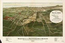
In the past 40 years, western Wauwatosa has become an edge city with an important commercial and retail district built up along Milwaukee's beltline Highway 100 and anchored by the Mayfair Mall.
Wauwatosa received some national attention in 1992 when the Wauwatosa Common Council, threatened with a lawsuit, decided to remove a Christian cross from the City's seal adopted in 1957. The cross was replaced with the text, "In God We Trust." The seal itself was designed by 9-year old Suzanne Vallier as an entry in a contest among Wauwatosa schoolchildren. The quadrants of the logo's shield represent, from top left going clockwise; an arrowhead representing the Indians who were the original inhabitants of the city, the mill representing Hart's Mill which was the original name of the city, the cross representing the "city of churches", and the symbol used on street signs representing the "city of homes."[12]
Geography
According to the United States Census Bureau, the city has a total area of 13.25 square miles (34.32 km2), all land.[2]
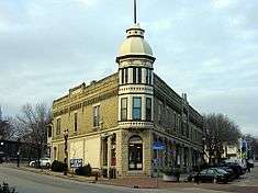
Eastern Wauwatosa is also known for its homes and residential streets, at one time just a short streetcar ride away from downtown Milwaukee. Prior to the arrival of Dutch elm disease, many of Wauwatosa's older residential streets had large gothic colonnades of American Elm trees. In Wauwatosa, the Menomonee Valley made it easier to quarry portions of the Niagara Escarpment, which provided the necessary materials for sturdy, cream-colored bricks and stout, limestone foundations used in many homes and public buildings throughout the region.
Demographics
| Historical population | |||
|---|---|---|---|
| Census | Pop. | %± | |
| 1900 | 2,842 | — | |
| 1910 | 3,346 | 17.7% | |
| 1920 | 5,818 | 73.9% | |
| 1930 | 21,194 | 264.3% | |
| 1940 | 27,769 | 31.0% | |
| 1950 | 33,324 | 20.0% | |
| 1960 | 56,923 | 70.8% | |
| 1970 | 58,676 | 3.1% | |
| 1980 | 51,310 | −12.6% | |
| 1990 | 49,484 | −3.6% | |
| 2000 | 47,271 | −4.5% | |
| 2010 | 46,396 | −1.9% | |
| Est. 2016 | 47,945 | [4] | 3.3% |
| Note: Town of Wauwatosa annexed
by City of Wauwatosa in 1952–54. | |||
As of 2000 the median income for a household in the city was $54,519, and the median income for a family was $68,030. Males had a median income of $46,721 versus $35,289 for females. The per capita income for the city was $28,834. About 2.3% of families and 3.8% of the population were below the poverty line, including 3.9% of those under age 18 and 5.5% of those age 65 or over.
2010 census
As of the census[3] of 2010, there were 46,396 people, 20,435 households, and 11,969 families residing in the city. The population density was 3,501.6 inhabitants per square mile (1,352.0/km2). There were 21,520 housing units at an average density of 1,624.2 per square mile (627.1/km2). The racial makeup of the city was 89.6% White, 4.5% African American, 0.3% Native American, 2.8% Asian, 0.1% Pacific Islander, 0.6% from other races, and 2.2% from two or more races. Hispanic or Latino of any race were 3.1% of the population.
There were 20,435 households of which 27.6% had children under the age of 18 living with them, 47.2% were married couples living together, 8.2% had a female householder with no husband present, 3.2% had a male householder with no wife present, and 41.4% were non-families. 34.3% of all households were made up of individuals and 14.5% had someone living alone who was 65 years of age or older. The average household size was 2.23 and the average family size was 2.92.
The median age in the city was 39.8 years. 21.9% of residents were under the age of 18; 5.8% were between the ages of 18 and 24; 28.9% were from 25 to 44; 26.7% were from 45 to 64; and 16.6% were 65 years of age or older. The gender makeup of the city was 46.6% male and 53.4% female.
Government
Wauwatosa has a mayor–council government. The mayor is elected to a four-year term.
The Common Council is composed of 16 aldermen, two from each of eight districts. They serve four-year terms, with one member from each district up for election every other year. The aldermen set policy and have extensive financial control, but are not engaged in daily operational management.
Politics
Wauwatosa voters have supported both Democratic and Republican candidates.
| United States presidential election in Wauwatosa, Wisconsin, 2016 [13] | ||||||
|---|---|---|---|---|---|---|
| Party | Candidate | Votes | Percentage | |||
| Democratic | Hillary Clinton | 16,316 | 56.87% | |||
| Republican | Donald Trump | 10,034 | 34.98% | |||
| Libertarian | Gary Johnson | 1,332 | 4.64% | |||
| Others | 918 | 3.2% | ||||
| United States Senate election in Wauwatosa, Wisconsin, 2016 [13] | ||||||
|---|---|---|---|---|---|---|
| Party | Candidate | Votes | Percentage | |||
| Democratic | Russ Feingold | 15,038 | 52.31% | |||
| Republican | Ron Johnson | 13,147 | 45.73% | |||
| Others | 563 | 1.96% | ||||
| Wisconsin gubernatorial election in Wauwatosa, Wisconsin, 2014 [14] | ||||||
|---|---|---|---|---|---|---|
| Party | Candidate | Votes | Percentage | |||
| Republican | Scott Walker | 12,875 | 51.83% | |||
| Democratic | Mary Burke | 11,713 | 47.16% | |||
| Others | 252 | 1.01% | ||||
| United States presidential election in Wauwatosa, Wisconsin, 2012 [15] | ||||||
|---|---|---|---|---|---|---|
| Party | Candidate | Votes | Percentage | |||
| Democratic | Barack Obama | 15,220 | 50.61% | |||
| Republican | Mitt Romney | 14,511 | 48.25% | |||
| Others | 344 | 1.14% | ||||
| United States Senate election in Wauwatosa, Wisconsin, 2012 [15] | ||||||
|---|---|---|---|---|---|---|
| Party | Candidate | Votes | Percentage | |||
| Republican | Tommy Thompson | 14,588 | 49.24% | |||
| Democratic | Tammy Baldwin | 14,516 | 49.00% | |||
| Others | 522 | 1.76% | ||||
| Wisconsin gubernatorial recall election in Wauwatosa, Wisconsin, June 2012 [16] | ||||||
|---|---|---|---|---|---|---|
| Party | Candidate | Votes | Percentage | |||
| Republican | Scott Walker | 14,059 | 53.63% | |||
| Democratic | Tom Barrett | 12,033 | 45.90% | |||
| Others | 125 | 0.47% | ||||
| Wisconsin gubernatorial election in Wauwatosa, Wisconsin, 2010 [17] | ||||||
|---|---|---|---|---|---|---|
| Party | Candidate | Votes | Percentage | |||
| Republican | Scott Walker | 12,579 | 51.84% | |||
| Democratic | Tom Barrett | 11,541 | 47.56% | |||
| Others | 144 | 0.06% | ||||
| United States presidential election in Wauwatosa, Wisconsin, 2008 [18] | ||||||
|---|---|---|---|---|---|---|
| Party | Candidate | Votes | Percentage | |||
| Democratic | Barack Obama | 15,568 | 52.49% | |||
| Republican | John McCain | 13,726 | 46.28% | |||
| Others | 367 | 1.23% | ||||
| Wisconsin gubernatorial election in Wauwatosa, Wisconsin, 2006 [19] | ||||||
|---|---|---|---|---|---|---|
| Party | Candidate | Votes | Percentage | |||
| Democratic | Jim Doyle | 11,986 | 49.61% | |||
| Republican | Mark Green | 11,803 | 48.85% | |||
| Others | 373 | 1.54% | ||||
| United States presidential election in Wauwatosa, Wisconsin, 2004 [20] | ||||||
|---|---|---|---|---|---|---|
| Party | Candidate | Votes | Percentage | |||
| Republican | George W. Bush | 16,169 | 53.55% | |||
| Democratic | John Kerry | 13,746 | 45.52% | |||
| Others | 281 | 0.93% | ||||
| Wisconsin gubernatorial election in Wauwatosa, Wisconsin, 2002 [21] | ||||||
|---|---|---|---|---|---|---|
| Party | Candidate | Votes | Percentage | |||
| Republican | Scott McCallum | 10,618 | 51.06% | |||
| Democratic | Jim Doyle | 8,675 | 41.72% | |||
| Libertarian | Ed Thompson | 1,030 | 4.95% | |||
| Others | 471 | 2.27% | ||||
| United States presidential election in Wauwatosa, Wisconsin, 2000 [22] | ||||||
|---|---|---|---|---|---|---|
| Party | Candidate | Votes | Percentage | |||
| Republican | George W. Bush | 16,093 | 55.73% | |||
| Democratic | Al Gore | 11,571 | 40.07% | |||
| Green | Ralph Nader | 1,019 | 3.53% | |||
| Others | 192 | 0.67% | ||||
Education
Wauwatosa is served by the Wauwatosa School District:[23]
- High Schools: Wauwatosa West, Wauwatosa East
- Middle Schools: Whitman, Longfellow
- Elementary Schools: Eisenhower, Jefferson, Lincoln, Madison, McKinley, Roosevelt, Underwood, Washington, Wilson
Catholic elementary schools in the city include Wauwatosa Catholic, St. Bernard, St. Joseph, St. Jude and Christ King. Lutheran Schools include Our Redeemer and St. John's.
Points of interest
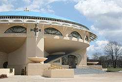
Wauwatosa contains Milwaukee County's Regional Medical Center, which includes the Medical College of Wisconsin, the Children's Hospital of Wisconsin, and Froedtert Hospital, one of two level-one trauma centers in the state. Other points of interest are the Annunciation Greek Orthodox Church designed by Frank Lloyd Wright; and the Memorial Center, built in 1957, which contains the public library, an auditorium, and the city hall. The Washington Highlands Historic District, a residential neighborhood designed in 1916 by renowned city planner Werner Hegemann, was added to the National Register of Historic Places in 1989, as was the Kneeland-Walker House. The Milwaukee County School of Agriculture and Domestic Economy Historic District, located on a former high school campus, was added in 1998. Other buildings on the list include Wauwatosa's oldest house, the Lowell Damon House; the Thomas B. Hart House; and the Wauwatosa Woman's Club Clubhouse.
Notable people
- Matt Adamczyk, American businessman and politician
- Antler, poet
- William Bast, screenwriter
- Henry S. Berninger, Wisconsin politician and businessman
- Fabian Bruskewitz, Bishop of the Roman Catholic Diocese of Lincoln
- Milton F. Burmaster, Wisconsin politician and lawyer
- Matthew Busche, cyclist
- Glenn R. Davis, U.S. Representative
- Fisk Holbrook Day, physician and geologist
- Nancy Dickerson, Peabody Award-winning journalist
- Anton Falch, professional baseball player
- Charles Fingado, Wisconsin politician
- Charles Thompson Fisher, Wisconsin politician and farmer
- James L. Foley, Jr., Wisconsin politician and farmer
- Albert Fowler, mayor of Rockford, Illinois
- Eric E. Hagedorn, Wisconsin politician and electrical engineer
- Devin Harris, professional basketball player of the NBA
- Judson G. Hart, Wisconsin farmer and politician
- Stephen F. Hayes, author and political commentator
- Julius P. Heil, Wisconsin governor
- Michael W. Hoover, presiding judge of the Wisconsin Court of Appeals
- Mike Huwiler, Olympic athlete, MLS player
- Michael G. Kirby, Wisconsin politician
- Christian A. Koenitzer, Wisconsin politician
- Joseph H. Loveland, Vermont politician
- William Martz, chess International Master
- Joseph McBride, author, film historian
- Ed McCully, Christian missionary killed during Operation Auca
- John Morgridge, former CEO and Chairman of the Board of Cisco Systems
- Walter Nortman, Wisconsin politician
- Charles B. Perry, Wisconsin politician
- Roger Ream, educator
- John E. Reilly, Jr., Wisconsin politician and judge
- Peggy Rosenzweig, Wisconsin politician
- Brad Rowe, actor
- Jeremy Scahill. investigative journalist, author, and director
- Richard Schickel, film critic and author
- William A. Schroeder, Wisconsin politician and lawyer
- Tony Smith, retired NBA player
- Jerry Smith, professional basketball player
- Thomas A. Steitz, Nobel Prize-winning chemist
- Michael Torke, Composer and musician, New York, NY
- Spencer Tracy, Hollywood actor
- Frederick D. Underwood, president of the Erie Railroad
- Scott Walker, Wisconsin governor
- Grace Weber, singer and songwriter
- David J. Wineland, Nobel Prize-winning physicist
- George Wylie, Wisconsin farmer and politician
References
- ↑ "QuickFacts – Wauwatosa city, Wisconsin". United States Census Bureau. Retrieved June 26, 2018.
- 1 2 "US Gazetteer files 2010". United States Census Bureau. Archived from the original on December 20, 2012. Retrieved June 26, 2018.
- 1 2 "American FactFinder". United States Census Bureau. Retrieved 2012-11-18.
- 1 2 "Population and Housing Unit Estimates". Retrieved June 9, 2017.
- ↑ "American FactFinder". United States Census Bureau. Retrieved 2008-01-31.
- ↑ "US Board on Geographic Names". United States Geological Survey. 2007-10-25. Retrieved 2008-01-31.
- ↑ Milwaukee Journal, April 12, 1957
- ↑ Milwaukee Journal, July 12, 1914
- ↑ Watrous, Jerome Anthony, Memoirs of Milwaukee County: from the earliest historical times down to the present, including a genealogical and biographical record of representative families in Milwaukee County, Chicago: Western Historical Association, 1909; Volume 1, pp. 69-70
- ↑ Village of Wauwatosa. "City of Wauwatosa Incorporated May 27, 1897 Under General Law, Recorded Misc. Rec. Vol. 5, PG. 397; Boundary Description" (PDF). Office of the Secretary of State of Wisconsin. Archived from the original (PDF) on 2007-07-04. Retrieved 2007-04-08.
- ↑ "City of Wauwatosa, Wisconsin: History: 1952" City of Wauwatosa website
- ↑ Milwaukee Journal, April 12, 1957
- 1 2 "Wauwatosa Election Results". November 8, 2016. Retrieved November 11, 2016.
- ↑ "Wauwatosa Election Results". November 4, 2014. Retrieved March 24, 2017.
- 1 2 "Wauwatosa Election Results". November 6, 2012. Retrieved November 11, 2016.
- ↑ "Wauwatosa Election Results". June 5, 2012. Retrieved November 11, 2016.
- ↑ "Wauwatosa Election Results". November 2, 2010. Retrieved March 14, 2017.
- ↑ "Wauwatosa Election Results". November 4, 2008. Retrieved November 11, 2016.
- ↑ "Wauwatosa Election Results". November 7, 2006. Retrieved March 14, 2017.
- ↑ "Wauwatosa Election Results". November 2, 2004. Retrieved November 11, 2016.
- ↑ "Wauwatosa Election Results". November 5, 2002. Retrieved March 14, 2017.
- ↑ "Wauwatosa Election Results". November 7, 2000. Retrieved November 11, 2016.
- ↑ Wauwatosa School District
External links
| Wikimedia Commons has media related to Wauwatosa, Wisconsin. |
Municipalities and communities of Milwaukee County, Wisconsin, United States | ||
|---|---|---|
| Cities | 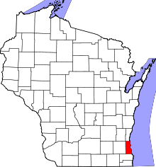 | |
| Villages | ||
| Ghost towns/ neighborhoods | ||
| Indian reservation | ||
| Footnotes | ‡This populated place also has portions in another county or counties | |
| Central city |  | |
|---|---|---|
| Largest municipalities (over 25,000 in 2010) | ||
| Municipalities (over 10,000 in 2010) | ||
| Smaller municipalities (under 10,000 in 2010) | ||
| Counties | ||

| Authority control |
|---|