Menomonee River
| Menomonee River | |
|---|---|
| Other name(s) | Menominee |
| Physical characteristics | |
| Main source | Milwaukee River |
| Length | 33 miles (53.1 km) |
| Discharge |
|
- See also Menominee River
The Menomonee River is one of three primary rivers in Milwaukee, Wisconsin.
Description
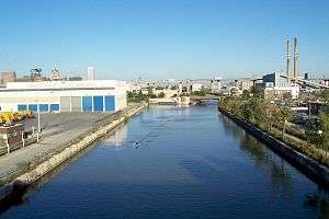
Named after the Menomonee (also spelled Menominee) Indians, the word was given to the Menomonee people by the Chippewa people, and in the Chippewa language literally means "rice eaters" referring to the abundant wild rice that once grew along its shores in the Menomonee Valley. A tributary of the Milwaukee River, it is the most industrialized within the Milwaukee River Basin.
Watershed
The Menomonee River is 33.0 miles (53.1 km) long,[1] with a watershed that covers approximately 140 square miles (360 km2) of urban landscape and is home to a population of more than 336,670 people. This includes portions of Washington, Ozaukee, Waukesha, and Milwaukee counties. A large swath of the river has been heavily channelized and industrialized as it runs through the Menomonee Valley. This has become a primary source of pollution for the river.
Its estuary empties into Lake Michigan from the Milwaukee River near the Milwaukee harbor, along with the Kinnickinnic River to the south.
References
- ↑ U.S. Geological Survey. National Hydrography Dataset high-resolution flowline data. The National Map Archived 2012-04-05 at WebCite, accessed May 19, 2011
External links
| Wikimedia Commons has media related to Menomonee River. |
- Menomonee River at Milwaukee Riverkeeper
- Menomonee River at Great Lakes Tributary Modeling Program
- Menomonee Valley Partners