Waconia, Minnesota
| Waconia, Minnesota | |
|---|---|
| City | |
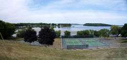 View of Lake Waconia | |
 Location of the city of Waconia within Carver County, Minnesota | |
| Country | United States |
| State | Minnesota |
| County | Carver |
| Government | |
| • Mayor | Jim Sanborn |
| Area[1] | |
| • Total | 4.39 sq mi (11.37 km2) |
| • Land | 4.34 sq mi (11.24 km2) |
| • Water | 0.05 sq mi (0.13 km2) |
| Population (2010)[2] | |
| • Total | 10,697 |
| • Estimate (2016)[3] | 11,964 |
| • Density | 2,400/sq mi (940/km2) |
| Time zone | UTC-6 (Central (CST)) |
| • Summer (DST) | UTC-5 (CDT) |
| ZIP code | 55387 |
| Area code(s) | 952 |
| Website |
www |
Waconia (/wəˈkoʊniːə/ wə-KOHN-ee-ə), a city in Carver County, Minnesota, United States. The city's population was 10,697 at the 2010 census and an estimated 11,964 in 2016.
Located in the central belt of the state, Waconia attracts visitors year-round for the renowned fishing on nearby Lake Waconia.
Geography
According to the United States Census Bureau, the city has a total area of 4.39 square miles (11.37 km2), of which, 4.34 square miles (11.24 km2) is land and 0.05 square miles (0.13 km2) is water.[1]
Minnesota State Highways 5 and 284; and Carver County Highway 10 are the main routes in Waconia.
Demographics
| Historical population | |||
|---|---|---|---|
| Census | Pop. | %± | |
| 1880 | 218 | — | |
| 1890 | 441 | 102.3% | |
| 1900 | 728 | 65.1% | |
| 1910 | 817 | 12.2% | |
| 1920 | 901 | 10.3% | |
| 1930 | 1,291 | 43.3% | |
| 1940 | 1,315 | 1.9% | |
| 1950 | 1,569 | 19.3% | |
| 1960 | 2,048 | 30.5% | |
| 1970 | 2,445 | 19.4% | |
| 1980 | 2,638 | 7.9% | |
| 1990 | 3,498 | 32.6% | |
| 2000 | 6,814 | 94.8% | |
| 2010 | 10,697 | 57.0% | |
| Est. 2016 | 11,964 | [3] | 11.8% |
| U.S. Decennial Census[4] 2013 Estimate[5] | |||
2000 census
As of the census[6] of 2000, there were 6,814 people, 2,568 households, and 1,848 families residing in the city. The population density was 2,432.0 people per square mile (939.6/km²). There were 2,646 housing units at an average density of 944.4 per square mile (364.9/km²). The racial makeup of the city was 97.06% White, 0.34% African American, 0.12% Native American, 0.65% Asian, 0.01% Pacific Islander, 1.00% from other races, and 0.82% from two or more races. Hispanic or Latino of any race were 1.28% of the population.
There were 2,568 households out of which 40.7% had children under the age of 18 living with them, 61.0% were married couples living together, 7.8% had a female householder with no husband present, and 28.0% were non-families. 23.3% of all households were occupied by one person and 12.2% had someone living alone who was 65 years of age or older. The average household size was 2.62 and the average family size was 3.12.
The city population had a wide age variety; with 29.9% being under the age of 18, 5.8% from 18 to 24, 35.5% from 25 to 44, 16.3% from 45 to 64, and 12.4% who were 65 years of age or older. The median age was 33 years. For every 100 females, there were 91.1 males. For every 100 females age 18 and over, there were 89.5 males.
The median income for a household in the city was $55,705, and the median income for a family was $67,703. Males had a median income of $43,535 versus $29,488 for females. The per capita income for the city was $26,996. About 2.9% of families and 3.8% of the population were below the poverty line, including 3.7% of those under age 18 and 9.5% of those age 65 or over.
2010 census
As of the census[2] of 2010, there were 10,697 people, 3,909 households, and 2,748 families residing in the city. The population density was 2,464.7 inhabitants per square mile (951.6/km2). There were 4,112 housing units at an average density of 947.5 per square mile (365.8/km2). The racial makeup of the city was 95.7% White, 1.1% African American, 0.3% Native American, 1.1% Asian, 0.7% from other races, and 1.1% from two or more races. Hispanic or Latino of any race were 2.5% of the population.
There were 3,909 households of which 45.2% had children under the age of 18 living with them, 60.1% were married couples living together, 7.1% had a female householder with no husband present, 3.0% had a male householder with no wife present, and 29.7% were non-families. 25.6% of all households were made up of individuals and 12% had someone living alone who was 65 years of age or older. The average household size was 2.70 and the average family size was 3.31.
The median age in the city was 34.9 years. 32.5% of residents were under the age of 18; 5% were between the ages of 18 and 24; 30.7% were from 25 to 44; 20.7% were from 45 to 64; and 11.3% were 65 years of age or older. The gender makeup of the city was 48.4% male and 51.6% female.
Education
Waconia Public Schools has a total of 5 public schools and 2 private schools:
- Southview Elementary, grades K–5
- Bayview Elementary, grades K–5
- Laketown Elementary, grades K-5
- Waconia Middle School, grades 6–8
- St. Joseph Catholic Education Center, grades PreK–8
- Trinity Lutheran School, grades K–8
- Waconia High School, grades 9–12
History
A post office has been in operation at Waconia since 1860.[7] The city took its name from Lake Waconia.[8]
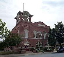
National Register of Historic Places gallery
Waconia has several buildings listed on the National Register of Historic Places (see: National Register of Historic Places listings in Carver County, Minnesota). One of the more prominent listings is for Coney Island of the West on Lake Waconia, where cottages, boathouses and resort hotels attracted tourists, especially from 1884 until the late 1920's, when the rise of the automobile allowed people to travel farther away for summer vacations.[9]
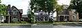 West Main Street Houses, from left to right 417, 429, and 453 W. Main St.
 Emile Amblard Guest House
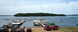 Coney Island of the West on Lake Waconia across from Waconia
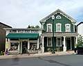 Mock Cigar Factory and House
 Charles Maiser House
Popular culture
- In the film Drop Dead Gorgeous, 1st Street near St. Joseph's Catholic Church in Waconia is used when the swan float explodes in the parade.
Notable people
- Susie Schmitt Hanson, (1860–1956)[10] milliner, dressmaker and entrepreneur
- Aaron Elling, NFL placekicker
- Joshua Hiltbrand, Notable dark matterist [11] [12]
- Don Herbert, Mr. Wizard and host of Mr. Wizard's World
- Maxx Williams, NFL tight end for the Baltimore Ravens, was born in Waconia
- Dalton Sawyer, minor league pitcher for the Nashville Sounds AAA team
- Andrew Peterson, (1818-1898), horticulturist, farmer, Swedish immigrant[13]
References
- 1 2 "US Gazetteer files 2010". United States Census Bureau. Retrieved 2012-11-13.
- 1 2 "American FactFinder". United States Census Bureau. Retrieved 2012-11-13.
- 1 2 "Population and Housing Unit Estimates". Retrieved June 9, 2017.
- ↑ United States Census Bureau. "Census of Population and Housing". Retrieved November 21, 2014.
- ↑ "Population Estimates". United States Census Bureau. Retrieved 2014-11-21.
- ↑ "American FactFinder". United States Census Bureau. Retrieved 2008-01-31.
- ↑ U.S. Geological Survey Geographic Names Information System: Waconia Post Office
- ↑ Upham, Warren (1920). Minnesota Geographic Names: Their Origin and Historic Significance. Minnesota Historical Society. p. 84.
- ↑ "Coney Island of the West, 1884–1960," Minnesota Historical Society
- ↑ Susie Schmitt Hanson
- ↑ https://www.physics.umn.edu/people/hiltbran.html
- ↑ https://arxiv.org/pdf/1808.05219.pdf
- ↑ http://www.mnopedia.org/person/peterson-andrew-1818-1898
External links
Municipalities and communities of Carver County, Minnesota, United States | ||
|---|---|---|
| Cities | 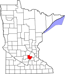 | |
| Townships | ||
| Unincorporated communities | ||
| Ghost town | ||
| Footnotes | ‡This populated place also has portions in an adjacent county or counties | |
Coordinates: 44°51′03″N 93°47′13″W / 44.85083°N 93.78694°W