Oster, Minnesota
| Oster, Minnesota | |
|---|---|
| Unincorporated community | |
 Oster, Minnesota Location of the community of Oster within Minnesota  Oster, Minnesota Oster, Minnesota (the US) | |
| Coordinates: 44°58′48″N 93°58′56″W / 44.98000°N 93.98222°WCoordinates: 44°58′48″N 93°58′56″W / 44.98000°N 93.98222°W | |
| Country | United States |
| State | Minnesota |
| Counties | Carver and Wright |
| Township | Hollywood Township and Woodland Township |
| Elevation | 994 ft (303 m) |
| Time zone | UTC-6 (Central (CST)) |
| • Summer (DST) | UTC-5 (CDT) |
| ZIP code | 55390 and 55360 |
| Area code(s) | 763 and 952 |
| GNIS feature ID | 654864[1] |
Oster is an unincorporated community in Carver and Wright Counties, Minnesota, United States.
The community is located along County Road 133 (CR 133) near 118th Street SW. 16th Street is also in the immediate area. Nearby places include Waverly, Mayer, New Germany, Winsted, Montrose, and Watertown.
Oster is located within Hollywood Township in Carver County; and also located within Woodland Township in Wright County.
References
Municipalities and communities of Carver County, Minnesota, United States | ||
|---|---|---|
| Cities | 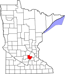 | |
| Townships | ||
| Unincorporated communities | ||
| Ghost town | ||
| Footnotes | ‡This populated place also has portions in an adjacent county or counties | |
Municipalities and communities of Wright County, Minnesota, United States | ||
|---|---|---|
| Cities |  | |
| Townships | ||
| CDP | ||
| Unincorporated communities | ||
| Ghost town | ||
| Footnotes | ‡This populated place also has portions in an adjacent county or counties | |
This article is issued from
Wikipedia.
The text is licensed under Creative Commons - Attribution - Sharealike.
Additional terms may apply for the media files.