Independence, Kentucky
| Independence, Kentucky | |
|---|---|
| City | |
 Kenton County Courthouse in Independence | |
 Location of Independence in Kenton County, Kentucky. | |
| Coordinates: 38°57′13″N 84°32′49″W / 38.95361°N 84.54694°WCoordinates: 38°57′13″N 84°32′49″W / 38.95361°N 84.54694°W | |
| Country | United States |
| State | Kentucky |
| County | Kenton |
| Named for | the establishment of Kenton Co. |
| Government | |
| • Mayor | Chris Reinersman |
| Area | |
| • Total | 16.8 sq mi (43.5 km2) |
| • Land | 16.8 sq mi (43.4 km2) |
| • Water | 0.0 sq mi (0.0 km2) |
| Elevation | 899 ft (274 m) |
| Population (2010) | |
| • Total | 24,757 |
| • Estimate (2016)[1] | 27,024 |
| • Density | 1,473.7/sq mi (570.4/km2) |
| Time zone | UTC−5 (Eastern (EST)) |
| • Summer (DST) | UTC−4 (EDT) |
| ZIP code | 41051 |
| Area code(s) | 859 |
| FIPS code | 21-39142 |
| GNIS feature ID | 0494900 |
| Website |
www |
Independence is a home rule-class city[2] in Kenton County, Kentucky, in the United States. It is one of its county's two seats of government. Independence is a suburb of Cincinnati, Ohio, and the population was 24,757 at the time of the 2010 U.S. census.
The current mayor of Independence is Chris Reinersman.
Geography
Independence is located at 38°57′13″N 84°32′49″W / 38.95361°N 84.54694°W (38.953668, -84.546990).[3] According to the United States Census Bureau, the city has a total area of 16.8 square miles (44 km2), of which 16.8 square miles (44 km2) is land and 0.06% is water.
History
The area post office was established by Isaac Everett in 1837 as Everett's Creek; in 1838, this was changed to Crews Creek (presumably after the present Cruises Creek); in 1839, Thomas Hordern renamed it Bagby.[4]
In 1840, Kenton was formed from Campbell and Boone counties. Local farmer John McCollum donated a site at the center of the new county to be its seat of governance and the name Independence was chosen to honor the liberation of locals from Campbell County.[4] The post office was renamed the same year. Quickly settled, Independence was formally incorporated by the state assembly in 1842.[5][6]
Because the majority of the county's population resided along the Ohio River, Independence was eventually obliged to share its status as county seat with the larger city of Covington, a situation later repeated in Campbell County between the centrally-located Alexandria and the larger, riverside Newport.
Demographics
| Historical population | |||
|---|---|---|---|
| Census | Pop. | %± | |
| 1850 | 182 | — | |
| 1860 | 189 | 3.8% | |
| 1870 | 134 | −29.1% | |
| 1880 | 165 | 23.1% | |
| 1900 | 193 | — | |
| 1910 | 153 | −20.7% | |
| 1920 | 153 | 0.0% | |
| 1930 | 260 | 69.9% | |
| 1940 | 253 | −2.7% | |
| 1950 | 285 | 12.6% | |
| 1960 | 309 | 8.4% | |
| 1970 | 1,715 | 455.0% | |
| 1980 | 7,998 | 366.4% | |
| 1990 | 10,444 | 30.6% | |
| 2000 | 14,982 | 43.5% | |
| 2010 | 24,757 | 65.2% | |
| Est. 2016 | 27,024 | [1] | 9.2% |
| U.S. Decennial Census[7] | |||
As of the census[8] of 2000, there were 14,982 people, 5,181 households, and 4,149 families residing in the city. The population density was 893.2 people per square mile (344.9/km²). There were 5,391 housing units at an average density of 321.4 per square mile (124.1/km²). The racial makeup of the city was 97.20% White, 0.96% African American, 0.18% Native American, 0.40% Asian, 0.02% Pacific Islander, 0.36% from other races, and 0.87% from two or more races. Hispanic or Latino of any race were 1.15% of the population.
There were 5,181 households out of which 44.9% had children under the age of 18 living with them, 62.9% were married couples living together, 12.1% had a female householder with no husband present, and 19.9% were non-families. 15.0% of all households were made up of individuals and 3.4% had someone living alone who was 65 years of age or older. The average household size was 2.89 and the average family size was 3.21.
In the city, the population was spread out with 30.4% under the age of 18, 9.2% from 18 to 24, 35.3% from 25 to 44, 18.5% from 45 to 64, and 6.5% who were 65 years of age or older. The median age was 31 years. For every 100 females, there were 101.6 males. For every 100 females age 18 and over, there were 97.3 males.
The median income for a household in the city was $51,002, and the median income for a family was $55,030. Males had a median income of $39,213 versus $26,807 for females. The per capita income for the city was $20,191. About 5.4% of families and 6.5% of the population were below the poverty line, including 9.2% of those under age 18 and 4.2% of those age 65 or over.
Economy
Major employers in Independence include Balluff,[9] Cengage Learning, Krauss Maffei, Mazak,[10] and Rotek.[11][12]
Cultural
Independence is served by a branch of the Kenton County Public Library.[13]
Schools
- Beechgrove Elementary School[14]
- Community Christian Academy[15]
- Kenton Elementary[16]
- Simon Kenton High School
- St. Cecilia Catholic School
- Summit View Elementary School[17]
- Summit View Academy[18]
- Twenhofel Middle School[19]
- Whites Tower Elementary[20]
* Some members of the community are districted for Woodland Middle School and Scott High School as well.
Parks
- Lincoln Ridge Park
- Bowman Field
- Doe Run Lake
- Memorial Park
- Mills Road Park
- Pioneer Park
- Richardson Road Park
- Sterling Staggs Park
Fire
References
- 1 2 "Population and Housing Unit Estimates". Retrieved June 9, 2017.
- ↑ "Summary and Reference Guide to House Bill 331 City Classification Reform" (PDF). Kentucky League of Cities. Retrieved December 30, 2014.
- ↑ "US Gazetteer files: 2010, 2000, and 1990". United States Census Bureau. 2011-02-12. Retrieved 2011-04-23.
- 1 2 Rennick, Robert M. (1987). Kentucky Place Names. University Press of Kentucky. p. 148. Retrieved 28 April 2013.
- ↑ Collins, Lewis (1877). History of Kentucky. p. 420.
- ↑ Commonwealth of Kentucky. Office of the Secretary of State. Land Office. "Independence, Kentucky". Accessed 29 July 2013.
- ↑ "Census of Population and Housing". Census.gov. Archived from the original on May 12, 2015. Retrieved June 4, 2015.
- ↑ "American FactFinder". United States Census Bureau. Archived from the original on September 11, 2013. Retrieved 2008-01-31.
- ↑ Balluff Inc. breaks ground on 3rd expansion in Independence
- ↑ "Mazak expands, renovates in Elsmere". cincinnati.com. Retrieved 13 April 2017.
- ↑ 2015 NKY 200 Archived June 23, 2015, at the Wayback Machine.
- ↑ Independence City Businesses
- ↑ "William E. Durr Branch". Kenton County Public Library. Retrieved 24 February 2018.
- ↑ "Beechgrove Elementary School". Retrieved 2018-07-06.
- ↑ "Community Christian Academy". ccaky.org. Retrieved 13 April 2017.
- ↑ "Kenton Elementary School". Retrieved 2018-07-06.
- ↑ "Summit View Elementary School". Retrieved 2018-07-06.
- ↑ "Summit View Academy". Retrieved 2018-07-06.
- ↑ "Twenhofel Middle School". Retrieved 2018-07-06.
- ↑ "White's Tower Elementary School". Retrieved 2018-07-06.
- ↑ "independencefire". independencekyfire.org. Retrieved 13 April 2017.
External links
- City website
- Historical Texts and Images of Independence, Kentucky
- 41051.com - A community website for Independence, Kentucky
Municipalities and communities of Kenton County, Kentucky, United States | ||
|---|---|---|
| Cities | 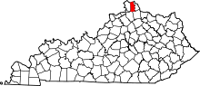 | |
| Unincorporated communities | ||
| Footnotes | ‡This populated place also has portions in an adjacent county or counties. | |
