Vrbas, Serbia
| Vrbas Врбас | |||
|---|---|---|---|
| Town and municipality | |||
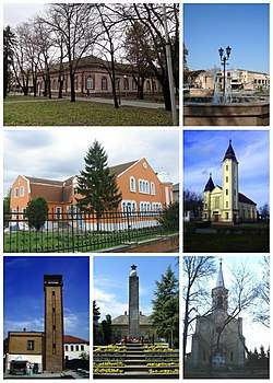 Vrbas- collage | |||
| |||
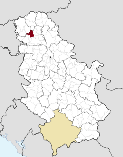 Location of the municipality of Vrbas within Serbia | |||
| Coordinates: 45°34′N 19°39′E / 45.567°N 19.650°ECoordinates: 45°34′N 19°39′E / 45.567°N 19.650°E | |||
| Country |
| ||
| Province | Vojvodina | ||
| District | South Bačka | ||
| Settlements | 7 | ||
| Government | |||
| • Mayor | Željko Vidović | ||
| Area[1] | |||
| • Municipality | 376 km2 (145 sq mi) | ||
| Elevation | 85 m (279 ft) | ||
| Population (2011 census)[2] | |||
| • Town | 24,112 | ||
| • Municipality | 42,092 | ||
| Time zone | UTC+1 (CET) | ||
| • Summer (DST) | UTC+2 (CEST) | ||
| Postal code | 21460 | ||
| Area code | +381 21 | ||
| Car plates | VS | ||
| Website |
www | ||

Vrbas (Serbian Cyrillic: Врбас, Hungarian: Verbász) is a town and municipality located in the South Bačka District of the autonomous province of Vojvodina, Serbia. As of 2011, the town had a population of 24,112, while the municipality had 42,092 inhabitants.
Name
Its name stems from the word "Willow" in the Serbian language. During the SFRY period, the town was renamed Titov Vrbas (meaning "the Vrbas of Tito"), after Josip Broz Tito. Like all other towns in Socialist Yugoslavia named after Tito, the first part was dropped once the new states were formed during the early 1990s.
In Rusyn, the town is known as Вербас, in Hungarian as Verbász, in Croatian as Vrbas, in German as Werbass, and in Turkish as Verbas.
History

Vrbas was mentioned first in 1213 during the administration of the Kingdom of Hungary. According to other sources, it was mentioned first in 1387.[3] In the 16th century it became a part of the Ottoman Empire. During Ottoman administration it was populated by ethnic Serbs.[4]
Since the Treaty of Passarowitz (1718), Vrbas and the Banat were placed under administration of the Habsburg Monarchy. According to the 1720 census, it was populated exclusively by Serbs (about 250 families[5]).[6]
After 1784 many Germans settled in the town founding a new settlement named Novi Vrbas (Neu-Verbasz) near the old Serb settlement, which then became known as Stari Vrbas (Old Vrbas).
In 1910, population of Novi Vrbas was mostly composed of ethnic Germans, while population of Stari Vrbas was ethnically mixed and was mainly composed of Serbs and Germans.[7]
In 1918, Vrbas became part of the Kingdom of Serbs, Croats and Slovenes, which was later renamed to Yugoslavia. The town was under Axis occupation in 1941-1944, and during that time it was attached to Horthy's Hungary. As a consequence of the World War II events in Yugoslavia, the German population fled from the town after this war. At the same time, many settlers from Montenegro came to Vrbas and other neighboring places.
Inhabited places
Vrbas municipality includes the city of Vrbas and the following villages:
Demographics

Historical population of the town
- 1961: 19,316
- 1971: 22,496
- 1981: 25,143
- 1991: 25,858
- 2011: 23,910
Ethnic groups
- Municipality
According to the 2011 census the municipality of Vrbas had a total population of 42,092, including:[8]
- Serbs 23,251 (55.24%)
- Montenegrins 7,353 (17.47%)
- Rusyns 3,375 (8.02%)
- Hungarians 2,464 (5.85%)
- Ukrainians 836 (1.99%)
- Croats 549 (1.30%)
Settlements with Serb ethnic majority are: Bačko Dobro Polje, Zmajevo, Kosančić, Ravno Selo and Vrbas. Ethnically mixed settlements are: Kucura (with relative Rusyn majority) and Savino Selo (with relative Montenegrin majority).
- Town
- Serbs (41.19%)
- Montenegrins (30.05%)
- Hungarians (7.73%)
- Rusyns (5.71%)
- Ukrainians (2.88%)
- Yugoslavs (2.04%)
- Croats (1.65%)
Languages
According to the 2002 census, 85% of inhabitants of the Vrbas municipality speak Serbian as mother tongue. Other spoken languages include Rusyn (8%), Hungarian (4%) and Ukrainian (1%).
Economy
The following table gives a preview of total number of employed people per their core activity (as of 2016):[9]
| Activity | Total |
|---|---|
| Agriculture, forestry and fishing | 404 |
| Mining | - |
| Processing industry | 2,733 |
| Distribution of power, gas and water | 110 |
| Distribution of water and water waste management | 197 |
| Construction | 103 |
| Wholesale and retail, repair | 1,258 |
| Traffic, storage and communication | 774 |
| Hotels and restaurants | 262 |
| Media and telecommunications | 54 |
| Finance and insurance | 131 |
| Property stock and charter | 7 |
| Professional, scientific, innovative and technical activities | 283 |
| Administrative and other services | 469 |
| Administration and social assurance | 556 |
| Education | 676 |
| Healthcare and social work | 1,074 |
| Art, leisure and recreation | 178 |
| Other services | 106 |
| Total | 9,375 |
Politics
Seats in the municipal parliament won in the 2004 local elections:
- Serbian Radical Party (14)
- Democratic Party (9)
- Socialist Party of Serbia (4)
- People's Democratic Party (2)
- Democratic Party of Serbia (2)
- New Social Democracy of Vojvodina (2)
- Strength of Serbia Movement (2)
- G17 Plus (1)
Notable citizens
- Molter Károly, writer (1890–1981)
- Vida Ognjenović, writer and director (b. 1941)
- Desanka Pešut, sports shooter (b. 1941)
- Lazar Ristovski, actor (b. 1952)
- Radoman Božović, politician and former Prime Minister of Serbia (b. 1953)
- Miodrag Kostić, businessman (b. 1959)
- Svetozar Šapurić, footballer (b. 1960)
- Igor Marojević, Serbian writer (b. 1968)
- Milorad Mažić, football referee (b. 1973)
- Magdolna Rúzsa, singer (b. 1985)
- Slobodan Vuković, footballer (b. 1986)
- Nikola Komazec, footballer (b. 1987)
- Ljubomir Fejsa, footballer (b. 1988)
- Bianka Buša, volleyball player (b. 1994)
- Milenko A. Perovic, philosopher
- Vladimir Kolarić, musician
- Milan Komnenić, poet
- Jozef Pehan, painter
- Mitar Pešikan, linguist
- Janko Benša, athletics
- Dragan Momić, handball player
- Nenad Njaradi, athletics
- Sava Vukosavljev, ethnomusicologist and composer
- Johannes Weidenheim, writer
- Viktor Ország, footballer
Gallery
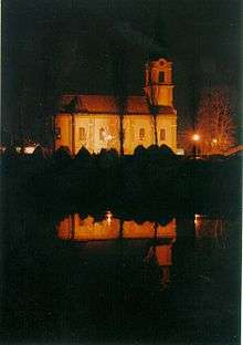
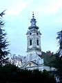 The Calvinist church.
 The Evangelical church.
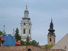
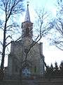 The Immaculate Conception of Blessed Virgin Mary Catholic Church.
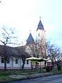 The Methodist church.
See also
References
- Slobodan Ćurčić, Broj stanovnika Vojvodine, Novi Sad, 1996.
- ↑ "Municipalities of Serbia, 2006". Statistical Office of Serbia. Retrieved 2010-11-28.
- ↑ "2011 Census of Population, Households and Dwellings in the Republic of Serbia: Comparative Overview of the Number of Population in 1948, 1953, 1961, 1971, 1981, 1991, 2002 and 2011, Data by settlements" (PDF). Statistical Office of Republic Of Serbia, Belgrade. 2014. ISBN 978-86-6161-109-4. Retrieved 2014-06-27.
- ↑ Dr Slobodan Ćurčić, Naselja Bačke - geografske karakteristike, Novi Sad, 2007, page 220.
- ↑ Dr Slobodan Ćurčić, Naselja Bačke - geografske karakteristike, Novi Sad, 2007, page 220.
- ↑ Dr Slobodan Ćurčić, Naselja Bačke - geografske karakteristike, Novi Sad, 2007, page 220.
- ↑ Ivan Jakšić, Iz popisa stanovništva Ugarske početkom XVIII veka, Novi Sad, 1966.
- ↑ http://img190.imageshack.us/img190/3899/vojvodina1910.png
- ↑ "Population by ethnicity – Vrbas". Statistical Office of the Republic of Serbia (SORS). Retrieved 11 March 2013.
- ↑ "ОПШТИНЕ И РЕГИОНИ У РЕПУБЛИЦИ СРБИЈИ, 2017" (PDF). stat.gov.rs (in Serbian). Statistical Office of the Republic of Serbia. Retrieved 16 March 2018.
External links
| Wikimedia Commons has media related to Vrbas. |


