Administrative divisions of Nepal
 |
|---|
| This article is part of a series on the politics and government of Nepal |
|
Executive:
Judiciary:
|
|
|
|
Related topics |
The administrative divisions of Nepal (Nepali: नेपालको प्रशासनिक विभाजन Nēpālakō praśāsanika vibhājana) are subnational administrative units of Nepal. The first level of country subdivisions of Nepal are the Provinces. Each province is further subdivided into districts, and each district into municipalities and rural municipalities. Before 2015, instead of provinces, Nepal was divided into developmental regions and administrative zones.
Fulfilling the requirement of the new constitution of Nepal in 2015, all old municipalities and villages (which were more than 3900 in number) were restructured into 753 new Municipalities and Villages.[1] [2] The former 75 district development committees (DDC) were also replaced by 77 new District Coordination Committees (DCC) which have much less power than the DDCs. At present there are 6 Metropolitan Cities, 11 Sub-Metropolitan Cities, 276 Municipalities, and 460 Rural Municipalities.
| Federal Government | |||||||||||||||||||||||||||||||||||
| 7 Province (e.g. Karnali Pradesh) | |||||||||||||||||||||||||||||||||||
| 77 District (e.g. Sunsari District) | |||||||||||||||||||||||||||||||||||
| 6 Metro City (e.g. Kathmandu) | 11 Sub-Metro City (e.g. Dharan) | 276 Municipality (e.g. Besisahar) | 460 Rural Municipality (e.g. Dordi) | ||||||||||||||||||||||||||||||||
Provinces
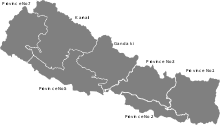
Nepal is composed of seven provinces.[3] They are defined by schedule 4 of the new constitution, by grouping together the existing districts. Two districts however are split in two parts ending up in two different provinces.
Provinces of Nepal according to current name, capital cities, area and population
| Provinces | Capital | Area (km2) | Population (2011) | |
|---|---|---|---|---|
| 1 | Province No. 1 | Biratnagar | 25,905 | 4,534,943 |
| 2 | Province No. 2 | Janakpur | 9,661 | 5,404,145 |
| 3 | Province No. 3 | Hetauda | 20,300 | 5,529,452 |
| 4 | Gandaki Pradesh | Pokhara | 21,504 | 2,413,907 |
| 5 | Province No. 5 | Butwal | 22,288 | 4,891,025 |
| 6 | Karnali Pradesh | Birendranagar | 27,984 | 1,168,515 |
| 7 | Sudurpashchim Pradesh | Godawari | 19,539 | 2,552,517 |
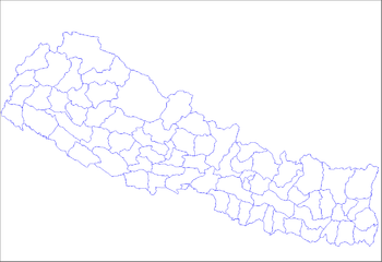
Districts
Provinces are further divided into districts, of which there are 77 (as of 2017).[4] Each districts is governed by a District Coordination Committee
Municipalities
Urban Municipalities
Municipalities are places having at least some minimum criteria of population and infrastructure and declared as a municipality by the government. There are 293 municipalities in Nepal.
Urban municipalities are categorized into 3 levels:
- Metropolitan city (Mahanagarpalika)
- Sub metropolitan city (Upmahanagarpalika)
- Municipality (Nagarpalika)
There are six metropolitan cities: The capital city Kathmandu, as well as Bharatpur, Biratnagar, Pokhara, Lalitpur and Birgunj. There are 11 Sub-metropolitan Cities and 276 Municipalities.
| Rank | Name | Province | Pop. | Rank | Name | Province | Pop. | ||
|---|---|---|---|---|---|---|---|---|---|
 Kathmandu  Pokhara |
1 | Kathmandu | Province No. 3 | 975,453 | 11 | Tulsipur | Province No. 5 | 141,528 |  Lalitpur  Bharatpur |
| 2 | Pokhara | Gandaki | 414,141 | 12 | Itahari | Province No. 1 | 140,517 | ||
| 3 | Lalitpur | Province No. 3 | 284,922 | 13 | Nepalgunj | Province No. 5 | 138,951 | ||
| 4 | Bharatpur | Province No. 3 | 280,502 | 14 | Butwal | Province No. 5 | 138,741 | ||
| 5 | Birgunj | Province No. 2 | 240,922 | 15 | Dharan | Province No. 1 | 137,705 | ||
| 6 | Biratnagar | Province No. 1 | 214,662 | 16 | Kalaiya | Province No. 2 | 123,659 | ||
| 7 | Janakpur | Province No. 2 | 159,468 | 17 | Jitpur Simara | Province No. 2 | 117,496 | ||
| 8 | Ghorahi | Province No. 5 | 156,164 | 18 | Mechinagar | Province No. 1 | 111,797 | ||
| 9 | Hetauda | Province No. 3 | 152,875 | 19 | Budhanilkantha | Province No. 3 | 107,918 | ||
| 10 | Dhangadhi | Sudurpashchim | 147,741 | 20 | Gokarneshwar | Province No. 3 | 107,351 | ||
Rural Municipalities
Rural municipalities (gaunpalikas) were established in 2017, replacing the village development committees. The main purpose of a gaunpalika resembles that of a village development committee, but it has more rights on collection of royalty and taxes and has a higher annual budget than the VDC. Several VDCs were usually combined into each new gaupalika. There are 460 gaunpalikas in Nepal.
Former developmental regions and zones
Prior to 10 September 2015, Nepal was divided into five developmental regions and fourteen administrative zones. At the time of the 2001 census, it was further subdivided into seventy-five districts. Districts were divided into village development committees (VDC) and municipalities. In the 2001 census, there were 3,915 VDCs and fifty-eight municipalities.[6]
Regions:
See also
References
- ↑ "New local level structure comes into effect from today". www.thehimalayantimes.com. The Himalayan Times. 10 March 2017. Retrieved 17 July 2018.
- ↑ "Govt prepares to add 9 more local levels in Province 2". www.kathmandupost.ekantipur.com. Kantipur Publication. 11 August 2017. Retrieved 15 August 2018.
- ↑ "Nepal divided by new constitution - Foreign Policy News". foreignpolicynews.org. Retrieved 2018-04-07.
- ↑ "There will be 77 districts in the country: Minister Thapa". My Republica. Retrieved 2018-04-07.
- ↑ 2011 Census District Level Detail Report, Central Bureau of Statistics.
- ↑ Administrative Divisions (Map). Kathmandu: Central Bureau of Statistics (CBS), Nepal. 2001. Archived from the original on 2 September 2018.
Administrative divisions of Asia | |
|---|---|
| Sovereign states |
|
| States with limited recognition | |
| Dependencies and other territories | |
| |
Subdivisions of Asia | |
|---|---|
| Sovereign states |
|
| States with limited recognition | |
| Dependencies and other territories | |
| |