Parasi District
| Parasi District परासी | |
|---|---|
| District | |
 | |
| Coordinates: 27°19′N 83°24′E / 27.32°N 83.40°E | |
| Country | Nepal |
| Province | Province No. 5 |
| Established | 2015 |
| Admin HQ. | Ramgram |
| Government | |
| • Type | Coordination committee |
| • Body | DCC, Parasi |
| Area | |
| • Total | 634.88 km2 (245.13 sq mi) |
| Population | |
| • Total | 321,058 |
| Time zone | UTC+5:45 (NPT) |
| Website | http://www.ddcnawalparasi.gov.np/ |
Parasi (Nepali: परासी) or (Nawalparasi west of Bardaghat Susta) is a district located in Province No. 5 of Nepal. It is 1 out of 12 districts of Province No. 5. The headquarter of the district is located in Ramgram. [1]
Formally Parasi District was part of Nawalparasi District, which splited into two districts Nawalpur District and Parasi after the state's reconstruction of administrative divisions as of 20 September 2015.
The total area of Parasi District is 634.88 square kilometres (245.13 sq mi) and total population of this district as of 2011 Nepal census is 321058 individuals. [2]
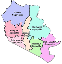
Divisions
The district is divided into 7 local level body[2] in which 3 are urban municipality and 4 are rural municipality.[3]
Urban municipality
Rural municipality
See also
References
- ↑ "पूर्वी नवलपरासीको नाम 'नवलपुर जिल्ला' र सदरमुकाम कावासोतीमा राख्ने निर्णय" [Decision to named Nawalpur of the East Nawalparasi and fix Headquarter at Kawasoti]. www.kantipurdaily.com (in Nepali). KMG. 22 September 2017. Retrieved 22 March 2018.
- 1 2 "CITY POPULATION– statistics, maps & charts". www.citypopulation.de. 8 October 2017. Retrieved 22 March 2018.
- ↑ "District Corrected Last for RAJAPATRA (page no. 261)" (PDF). www.mofald.gov.np. Retrieved 2 March 2018.
External links

This article is issued from
Wikipedia.
The text is licensed under Creative Commons - Attribution - Sharealike.
Additional terms may apply for the media files.