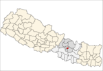
Bhaktapur District
| Bhaktapur District भक्तपुर जिल्ला | |
|---|---|
| District | |
 Kathmandu Valley, Bhaktapur District | |
| Nickname(s): Khowpa | |
| Coordinates: 27°40′20″N 85°25′40″E / 27.672222°N 85.427778°E | |
| Country | Nepal |
| Province | Province No. 3 |
| Headquarters | Bhaktapur |
| Area | |
| • Total | 119 km2 (46 sq mi) |
| Population (2011) | |
| • Total | 304,651[1][2] |
|
2001 pop.: 225,461 1991 pop.: 172,952 1981 pop.: 159,767 | |
| Time zone | UTC+5:45 (NPT) |
| Area code(s) | +977-1 |
| Website |
www |
Bhaktapur district(Nepali: भक्तपुर जिल्ला![]()
Education
Bhaktapur has been making tremendous achievements in educational sector.
The average literacy rate of Bhaktapur is 81.68, where male - 90.48 and female - 72.65 which growing with the educational awareness among peoples.
The governmental schools in Bhaktapur are making remarkable improvement in its educational quality.[5] The government schools have been starting to facilitate students by teaching in both English and Nepali medium.Private schools too are well known for providing quality education.
Despite topping other districts in SLC with highest enrollments, the higher studies of the Bhaktapur is not quite satisfactory. There is not enough college in Bhaktapur rendering qualitative services. That's why, students of Bhaktapur complete their higher studies in colleges of Kathmandu and Lalitpur. However, their academic performance in those college cannot be neglected. Khwopa College situated in Dekocha Bhaktapur is one of topmost college in Nepal. The academic results of this college is outstanding. This college is established and managed by Bhaktapur municipality.
Health care
Bhaktapur lags behind to Kathmandu District and Lalitpur District when it comes to medical service.Bhaktapur does not have enough hospitals rendering Qualitative medical facilities.
However, the only cancer hospital Bhaktapur Cancer Hospital,[6] National Tuberculosis Centre and Ayurvedic Centre is located in Bhaktapur.Recently, the Government of Nepal has decided to transfer Bir hospital, the oldest hospital in Nepal, to Duwakot,Bhaktapur.
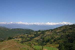
Geography and Climate
| Climate Zone[7] | Elevation Range | % of Area |
|---|---|---|
| Subtropical | 1,000 to 2,000 meters 3,300 to 6,600 ft. |
99.4% |
| Temperate | 2,000 to 3,000 meters 6,400 to 9,800 ft. |
0.6% |
Municipalities
The district is divided into four municipalities:
Places of interest
- Bhaktapur Durbar Square
- Taumadhi
- Nagarkot
- Changu Narayan
- Siddha Pokhari
- Kailashnath Mahadev Statue
- Doleshwor Mahadev
- Pilot Baba Ashram
- Kathmandu Fun Valley
- Anantalingeshwor Mahadev
Gallery
 Bhairavnath Temple,Bhaktapur Durbar Square
 Taumadhi Square,Bhaktapur Durbar Square
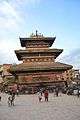
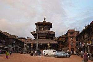 Dattatreya Temple,Bhaktapur Durbar Square
%2C_built_during_the_reign_of_King_Yakshya_Malla_in_the_early_15th_century%2C_Bhaktapur.jpg) Siddha Pokhari
Siddha Pokhari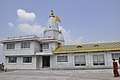 Pilot Baba Ashram, Gundu
See also
References
- ↑ "National Planning Commission Secretariat, Central Bureau of Statistics. Nepal". Archived from the original on 2016-08-16.
- ↑ "STATISTICAL YEAR BOOK OF NEPAL - 2011" (PDF).
- ↑ "National Population and Housing Census 2011(National Report)" (PDF). Central Bureau of Statistics. Government of Nepal. November 2012. Archived from the original (PDF) on 2013-04-18. Retrieved November 2012. Check date values in:
|accessdate=(help) - ↑ http://census.gov.np/images/pdf/Preliminary%20Leaflet%202011.pdf%5Bpermanent+dead+link%5D
- ↑ "District Education Office, Bhaktapur".
- ↑ "Bhaktapur Cancer hospital". ncrs.org.np.
- ↑ The Map of Potential Vegetation of Nepal - a forestry/agroecological/biodiversity classification system (PDF), . Forest & Landscape Development and Environment Series 2-2005 and CFC-TIS Document Series No.110., 2005, ISBN 87-7903-210-9, retrieved Nov 22, 2013
External links
- Tourism, Travel, & Information Guide to the Royal City of Bhaktapur in Nepal.
- "Districts of Nepal". Statoids.
| Province No. 1 |  | |
|---|---|---|
| Province No. 2 | ||
| Province No. 3 | ||
| Gandaki Pradesh | ||
| Province No. 5 | ||
| Karnali Pradesh | ||
| Sudurpashchim Pradesh | ||
Headquarter: Bhaktapur | |||
 |  | ||