Salyan, Nepal
| Salyān सल्यान खलङ्गा Salyān Khalangā | |
|---|---|
| Municipality | |
 Salyān Location in Nepal | |
| Coordinates: 28°22′31″N 82°9′42″E / 28.37528°N 82.16167°ECoordinates: 28°22′31″N 82°9′42″E / 28.37528°N 82.16167°E | |
| Country |
|
| Development Region | Mid-Western |
| Zone | Rapti Zone |
| District | Salyan District |
| Elevation | 1,530 m (5,020 ft) |
| Postal code | 22200 |
| Area code(s) | 088 |
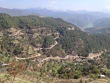
Salyan or Salyan Khalanga is the headquarters of Salyan District in the mid-west 'hills' of Nepal. It is located at 28°22'31N 82°9'42E at 1530 metres elevation (5020 feet).[1]
Rapti Highway from Tulsipur follows the Sarda River 3 km. (1.9 miles) east of the town at 1,000 meters (3,280 feet) elevation. As of 2010 it was being extended north to Musikot, Rukum District A spur road from this highway climbs up to Salyan Khalanga and the town has bus connections to Tulsipur, Ghorahi and Mahendra Highway.
References
Headquarters: Salyan (today part of Shaarda Municipality) | ||
| Municipalities | 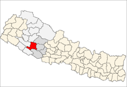 | |
| Rural municipalities |
| |
| Former VDCs |
| |
List of municipalities and rural municipalities of Nepal | ||
This article is issued from
Wikipedia.
The text is licensed under Creative Commons - Attribution - Sharealike.
Additional terms may apply for the media files.