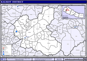
Kalikot District
| Kalikot District कालीकोट जिल्ला | |
|---|---|
| District | |
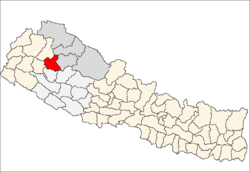 | |
| Country | Nepal |
| Province | Karnali Pradesh |
| Admin HQ. | Manma (today part of Khandachakra Municipality) |
| Government | |
| • Type | Coordination committee |
| • Body | DCC, Kalikot |
| Area | |
| • Total | 1,741 km2 (672 sq mi) |
| Population (2011) | |
| • Total | 136,948 |
| • Density | 79/km2 (200/sq mi) |
| Time zone | UTC+5:45 (NPT) |
Kalikot District (Nepali: कालीकोट जिल्ला![]()
Geography and Climate
| Climate Zone[2] | Elevation Range | % of Area |
|---|---|---|
| Upper Tropical | 300 to 1,000 meters 1,000 to 3,300 ft. |
1.8% |
| Subtropical | 1,000 to 2,000 meters 3,300 to 6,600 ft. |
20.6% |
| Temperate | 2,000 to 3,000 meters 6,400 to 9,800 ft. |
39.4% |
| Subalpine | 3,000 to 4,000 meters 9,800 to 13,100 ft. |
37.3% |
| Alpine | 4,000 to 5,000 meters 13,100 to 16,400 ft. |
0.8% |
Administration
The district consists of nine municipalities, out of which four are urban municipalities and five are rural municipalities. These are as follows:[3]
- Khandachakra Municipality
- Raskot Municipality
- Tilagufa Municipality
- Pachaljharana Rural Municipality
- Sanni Triveni Rural Municipality
- Narharinath Rural Municipality
- Shubha Kalika Rural Municipality
- Mahawai Rural Municipality
- Palata Rural Municipality
Former Village Development Committees
Prior to the restructuring of the district, Kalikot District consisted of the following municipalities and Village development committees:
See also
References
- ↑ Country Reports on Human Rights Practices - 2005 - US Department of State
- ↑ The Map of Potential Vegetation of Nepal - a forestry/agroecological/biodiversity classification system (PDF), Forest & Landscape Development and Environment Series 2-2005 and CFC-TIS Document Series No.110., 2005, ISBN 87-7903-210-9, retrieved Nov 22, 2013
- ↑ "स्थानिय तह" (in Nepali). Ministry of Federal Affairs and General Administration. Retrieved 1 September 2018.
External links
Headquarters: Manma (today part of Khandachakra Municipality) | ||
| Municipalities | | |
| Rural municipalities | ||
| Former VDCs | ||
List of municipalities and rural municipalities of Nepal | ||
| Province No. 1 |  | |
|---|---|---|
| Province No. 2 | ||
| Province No. 3 | ||
| Gandaki Pradesh | ||
| Province No. 5 | ||
| Karnali Pradesh | ||
| Sudurpashchim Pradesh | ||
Coordinates: 29°9′0″N 81°37′0″E / 29.15000°N 81.61667°E
| Wikimedia Commons has media related to Kalikot District. |