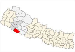
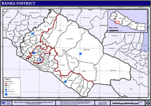
Banke District
| Banke District बाँके | |
|---|---|
| District | |
 | |
| Country | Nepal |
| Admin HQ. | Nepalganj |
| Government | |
| • Type | Coordination committee |
| • Body | DCC, Banke |
| Area | |
| • Total | 2,337 km2 (902 sq mi) |
| Population (2011) | |
| • Total | 491,313[1] |
| Time zone | UTC+5:45 (NPT) |
| Main Language(s) | Nepali |
Banke District (Nepali: बाँके जिल्ला![]()
Geography and Climate
Banke is bordered on the west by Bardiya district. Rapti zone's Salyan and Dang Deukhuri Districts border to the north and east. To the south lies Uttar Pradesh, India, a country in Asia; specifically Shravasti and Bahraich districts of Awadh. East of Nepalganj the international border follows the southern edge of the Dudhwa Range of the Siwaliks.
Most of the district is drained by the Rapti, except the district's western edge is drained by the Babai. Rapti and Babai cross into Uttar Pradesh, a state in India, Nepal's neighboring country and eventually join the Karnali, whose name has changed to Ghaghara.
| Climate Zone[3] | Elevation Range | % of Area |
|---|---|---|
| Lower Tropical | below 300 meters (1,000 ft) | 79.1% |
| Upper Tropical | 300 to 1,000 meters 1,000 to 3,300 ft. |
20.6% |
| Subtropical | 1,000 to 2,000 meters 3,300 to 6,600 ft. |
0.3% |
Sub- Metropolitan City, Municipality and Rural Municipalities
There are one Sub-metropolitan city, one Municipality and six Rural Municipalities in Banke District.
- Nepalgunj Sub-Metropolitan City
- Kohalpur Municipality
- Rapti-Sonari Rural Municipality
- Narainapur Rural Municipality
- Duduwa Rural Municipality
- Janaki Rural Municipality
- Khajura Rural Municipality
- Baijanath Rural Municipality
Former VDCs and Municipalities
- Bageswari
- Bashudevpur
- Baijapur
- Belahari
- Belbhar
- Betahani
- Bhawaniyapur
- Binauna
- Chisapani
- Ganapur
- Gangapur
- Hirminiya
- Holiya
- Indrapur
- Jaispur
- Kalaphanta
- Kamdi
- Kanchanapur
- Kathkuiya
- Khajura Khurda
- Khaskarkado
- Khaskusma
- Kohalpur
- Laksmanpur
- Mahadevpuri
- Manikapur
- Matahiya
- Narainapur
- Naubasta
- Nepalganj
- Parsapur
- Phatepur
- Piparhawa
- Puraina
- Puraini
- Radhapur
- Rajhena
- Raniyapur
- Saigaun
- Samserganj
- Sitapur
- Sonapur
- Titahiriya
- Udarapur
- Udayapur
See also
References
- 1 2 "National Population and Housing Census 2011(National Report)" (PDF). Central Bureau of Statistics. Government of Nepal. November 2012. Archived from the original (PDF) on 2013-04-18. Retrieved November 2012. Check date values in:
|accessdate=(help) - ↑ "Nepal Census 2001". Nepal's Village Development Committees. Digital Himalaya. Archived from the original on 12 October 2008. Retrieved 12 December 2008.
- ↑ The Map of Potential Vegetation of Nepal - a forestry/agroecological/biodiversity classification system (PDF), . Forest & Landscape Development and Environment Series 2-2005 and CFC-TIS Document Series No.110., 2005, ISBN 87-7903-210-9, retrieved Nov 22, 2013
- "Districts of Nepal". Statoids.
| Province No. 1 |  | |
|---|---|---|
| Province No. 2 | ||
| Province No. 3 | ||
| Gandaki Pradesh | ||
| Province No. 5 | ||
| Karnali Pradesh | ||
| Sudurpashchim Pradesh | ||
| Wikimedia Commons has media related to Banke District. |
Coordinates: 28°03′N 81°37′E / 28.050°N 81.617°E