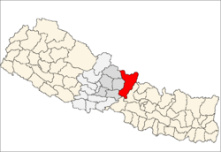
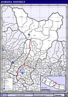
Gorkha District
| Gorkha District गोरखा | |
|---|---|
| District | |
 | |
| Country | Nepal |
| Province | Gandaki Pradesh |
| Established | 12th century |
| Government | |
| • Type | Coordination committee |
| • Body | DCC, Gorkha |
| Area | |
| • Total | 3,610 km2 (1,390 sq mi) |
| Population (2011) | |
| • Total | 272,169 |
| • Density | 75/km2 (200/sq mi) |
| Time zone | UTC+5:45 (NPT) |
| Main Language(s) | Nepali, Ghale, Gurung, Magar, Newari |
Gorkha District (Nepali: गोरखा जिल्ला ![]()
Origin
There are three major legends associated with naming of "Gorkha".
- In Nepali,‘ Kharka’ means ‘Grass Land’. This land was believed to be like meadow in Ancient period. Thus it was named Kharka and later the term Kharka got modified to Garkha and Garkha changed to Gorkha.
- In Sanskrit Scripture, ‘Gorakshaa’ means the protection of cow. Since Nepal is a country where killing a Cow is considered unholy and a very serious crime, the land was named Goraksha and later it became Gorkha.
- Myth holds that a Saint named Gorakhnath appeared for the first in Nepal in Gorkha. There is still a cave with his paduka (feet) and idol of him in this place which supports the myth. Thus since the city was established in the place where Sage Gorakhnath appeared, it was named ‘Gorkha’.
Places to visit
- River Daraundi Club masel.
- Manakamana Temple: The Manakamana Temple situated in the Gorkha district of Nepal is the sacred place of the Hindu Goddess Bhagwati, an incarnation of Parvati. The name Manakamana originates from two words, "mana" meaning heart and "kamana" meaning wish. Venerated since the 17th century, it is believed that Goddess Bhagawati grants the wishes of all those who make the pilgrimage to her shrine to worship her.
 Cable Car connecting Kurintaar to Manakamana temple
 - Gorakhnath: It lies ten meters down the southern side of Gorkha Palace which is visited with great devotion by Brahmans and Chhetris considering it to be the holy pilgrimage Site. Great fare is organized each year on the day of Baisakh Purnima(the full moon Day of Baisakh) in Gorakhnath Cave.
- Gorakhkali Temple: This Temple is located at the west side of the Gorkha Palace.
- Chepe, Daraudi, Marsyangdi and Budhi Gandaki.
- Gorkha Kingdom: About 1700 steps leads you to the top of the hill at an altitude of 3281 ft. where Newar fashioned Gorkha Palace stands firm along with forts and temple boasting on its rich History. It is at 40–50 minutes of Walking Distance far from Gorkha Bazaar. One can view Manaslu(the 8th Highest Mountain of the World), Dhaulagiri and Ganesh Mountains from the Palace Complex.
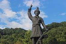 Prithvi Narayan Shah, last King of Gorkha Kingdom and first one of Kingdom of Nepal
 - Manaslu: Eighth highest mountain in the world
.jpg) Manaslu at sunrise
Manaslu at sunrise - Ligligkot and Lakhan Thapa Gaon are popular places in Gorkha for Hiking, Liglig has an interesting history.
- Dhike Dada is a new attraction for public from Gorkha,Tanahun and Lamjung.
Geography and climate
| Climate Zone[3] | Elevation Range | % of Area |
|---|---|---|
| Lower Tropical | below 300 meters (1,000 ft) | 0.1% |
| Upper Tropical | 300 to 1,000 meters 1,000 to 3,300 ft. |
19.8% |
| Subtropical | 1,000 to 2,000 meters 3,300 to 6,600 ft. |
14.6% |
| Temperate | 2,000 to 3,000 meters 6,400 to 9,800 ft. |
13.3% |
| Subalpine | 3,000 to 4,000 meters 9,800 to 13,100 ft. |
14.9% |
| Alpine | 4,000 to 5,000 meters 13,100 to 16,400 ft. |
10.6% |
| Nival | above 5,000 meters | 11.5% |
| Trans-Himalayan[4] | 3,000 to 6,400 meters 9,800 to 21,000 ft. |
14.8% |
Transport
Gorkha town has daily bus services to and from Kathmandu (six hours) and Pokhara (three hours).[6]
Health care

Following is the data obtained from the PHASE Nepal website:
- Central/regional/zonal hospitals: 0
- District hospitals: 2
- Primary healthcare centres: 3
- Health posts: 10
- Sub-health post: 55
- Number of doctors: 8
A district hospital is in Gorkha, the municipal hospital in Amppipal is supported by a German NGO.
The small health centers in many village development committees (VDCs) are without Auxiliary Health Workers (AHWs), Auxiliary Nurse Midwives (ANMs) and Community Health Workers (CHWs). So, people seeking emergency health assistance have to travel a long distance to the district headquarters or Kathmandu or end up dying because of lack of treatment. Many people still believe in Dhami and Jhakri and are against taking medicine or going to the hospital for the treatment. An NGO, PHASE Nepal provides many health care facilities and training programs to three VDCs: Sirdibas, Bihi/Prok and Chumchet. Many people residing in these VDCs have benefited from the program.[7]
Educational status
As per the National Population and Housing Census of Nepal 2011, the literacy rate of Gorkha is 66.34%. The female literacy rate is 59.44% and the male literacy rate is 75.09%.
- Drabya Saha Multiple Campus, Prithvi Narayan Muniplicity-8, Laxmi Bazar
- Gorkha Campus, Prithvi Narayan Muniplicity, Gorkha
- Bhawani Multiple Campus, Palungtar, Gorkha
- Dullav Campus, Masel, Ghyampesal, Gorkha
- Paropakar Adarsha Multiple Campus, Jaubari, Gorkha
- Bheemodaya Multiple Campus, Aarughat, Gorkha
Administration
The district consists of 11 Municipalities, out of which two are urban municipalities and nine are rural municipaliies. These are as follows:[8]
- Gorkha Municipality
- Palungtar Municipality
- Sulikot Rural Municipality
- Siranchok Rural Municipality
- Ajirkot Rural Municipality
- Chum Nubri Rural Municipality
- Dharche Rural Municipality
- Bhimsen Rural Municipality
- Sahid Lakhan Rural Municipality
- Aarughat Rural Municipality
- Gandaki Rural Municipality
Former Village Development Committees
Prior to the restructuring of the district, Gorkha District consisted of the following municipalities and Village development committees:
- Aanppipal
- Aaru Arbang
- Aaru Chanuate
- Aarupokhari
- Asrang
- Baguwa
- Bakrang
- Bhirkot
- Bhumlichok
- Bihi
- Borlang
- Barpak
- Bunkot
- Chhaikampar
- Chhoprak
- Chumchet
- Chyangli
- Darbhung
- Deurali
- Dhawa
- Dhuwakot
- Gaikhur
- Gakhu
- Ghairung
- Ghyachok
- Ghyalchok
- Gorakhkali
- Gorkha Municipality
- Gumda
- Hansapur
- Harmi
- Jaubari
- Kashigaun
- Kerabari
- Kerauja
- Kharibot
- Khoplang
- Laprak
- Lapu
- Lho
- Makaising
- Manakamana
- Manbu
- Masel
- Mirkot
- Muchhok
- Namjung
- Nareshwar
- Palungtar Municipality
- Panchkhuwadeurali
- Pandrung
- Phinam
- Phujel
- Prok
- Ranishwara
- Samagaun
- Saurpani
- Srinathkot
- Simjung
- Sirdibas
- Swara
- Taklung
- Takukot
- Takumajhalakuribot
- Tandrang
- Tanglichok
- Taple
- Tara Nagar
- Thalajung
- Thumi
- Uiya
- Warpak
Mountains
- Manaslu ( 8,516 m )
- Himalchuli (7,895 m)
- Shringi Himal (7,177 m)
- Buddha Himal (6,674 m )
- Ganesh Himal ( 7,422 m )
- Ngadi Chuli (7,871 m)
- Nar Phu : Peri Range 5748 m
- Ganesh VI : Ganesh Himal range (6480 m)
- Tobsar Peak : Shringi Himal range (6100m)
References
- ↑ "National Population and Housing Census 2011(National Report)" (PDF). Central Bureau of Statistics. Government of Nepal. November 2012. Archived from the original (PDF) on 2013-04-18. Retrieved November 2012. Check date values in:
|accessdate=(help) - ↑ "Dakshinkali and Manakamana temple". enepalholidays.com.
- ↑ The Map of Potential Vegetation of Nepal - a forestry/agroecological/biodiversity classification system (PDF), Forest & Landscape Development and Environment Series 2-2005 and CFC-TIS Document Series No.110., 2005, ISBN 87-7903-210-9, retrieved Nov 22, 2013
- ↑ Shrestha, Mani R.; Rokaya, Maan B.; Ghimire, Suresh K. (2005). "Vegetation pattern of Trans-Himalayan zone in the North-West Nepal". Nepal Journal of Plant Sciences. 1: 129–135. Retrieved Feb 7, 2014.
- ↑ Banerji, Gargi; Basu, Sejuti. "Climate Change and Himalayan Cold Deserts: Mapping vulnerability and threat to ecology and indigenous livelihoods" (PDF). Pragya. Gurgaon, Haryana, India. Retrieved February 7, 2014.
- ↑ http://www.tourismkathmandu.com/things_to_do/kathmandu_and_surrounds/details/gorkha
- ↑ "Project Area: Gorkha". PHASE Nepal.
- ↑ "स्थानिय तह" (in Nepali). Ministry of Federal Affairs and General Administration. Retrieved 1 September 2018.
External links
- "Districts of Nepal". Statoids.
| Wikimedia Commons has media related to Gorkha District. |
Headquarters: Gorkha Municipality | ||
| Municipalities | | |
| Rural municipalities |
| |
| Former VDCs |
| |
| Province No. 1 |  | |
|---|---|---|
| Province No. 2 | ||
| Province No. 3 | ||
| Gandaki Pradesh | ||
| Province No. 5 | ||
| Karnali Pradesh | ||
| Sudurpashchim Pradesh | ||
Coordinates: 28°17′24″N 84°41′23″E / 28.289976°N 84.68975°E