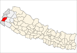
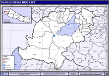
Dadeldhura District
| Dadeldhura District डडेलधुरा | |
|---|---|
| District | |
 | |
| Country | Nepal |
| Province | Province No. 7 |
| Admin HQ. | Amargadhi[1] |
| Government | |
| • Type | Coordination committee |
| • Body | DCC, Dadeldhura |
| Area | |
| • Total | 1,538 km2 (594 sq mi) |
| Population (2011) | |
| • Total | 142,094[2] |
| Time zone | UTC+5:45 (NPT) |
| Main Language(s) | Dotiyali |
Dadeldhura district (Nepali: डडेलधुरा जिल्ला![]()
The region has a desert-mountainous landscape that contains many religious temples. The district is seldom visited by tourists but contains local routes to Mt Kailaish in Tibet, Ra Ra Lake in Humla district and the last remaining remnants of the Far Western Malla Kingdom. Nagi Malla was the last royal to live here before Nepalese unification.
The spoken language is Dotyal and the majority of inhabitants are Hindu. The district is rural but some modernization is occurring. Dadeldhura is the most developed district among the other hilly districts in far Western region.
Geography and Climate
| Climate Zone[4] | Elevation Range | % of Area |
|---|---|---|
| Lower Tropical | below 300 meters (1,000 ft) | 0.6% |
| Upper Tropical | 300 to 1,000 meters 1,000 to 3,300 ft. |
34.7% |
| Subtropical | 1,000 to 2,000 meters 3,300 to 6,600 ft. |
55.8% |
| Temperate | 2,000 to 3,000 meters 6,400 to 9,800 ft. |
8.9% |
Administration
The district consists of seven municipalities, out of which two are urban municipalities and five are rural municipalities. These are as follows:[5]
- Amargadhi Municipality
- Parshuram Municipality
- Aalital Rural Municipality
- Bhageshwor Rural Municipality
- Navadurga Rural Municipality
- Ajayameru Rural Municipality
- Ganyapadhura Rural Municipality
Former Village Development Committees
Prior to the restructuring of the district, Dadeldhura District consisted of the following Village development committees:
See also
References
- ↑ "Amargadhi Municipality". The Government of Nepal. Retrieved 1 September 2018.
- 1 2 "National Population and Housing Census 2011(National Report)" (PDF). Central Bureau of Statistics. Government of Nepal. November 2012. Archived from the original (PDF) on 2013-04-18. Retrieved November 2012. Check date values in:
|accessdate=(help) - ↑ "Nepal Census 2001". Nepal's Village Development Committees. Digital Himalaya. Archived from the original on 12 October 2008. Retrieved 12 December 2008.
- ↑ The Map of Potential Vegetation of Nepal - a forestry/agroecological/biodiversity classification system (PDF), Forest & Landscape Development and Environment Series 2-2005 and CFC-TIS Document Series No. 110., 2005, ISBN 87-7903-210-9, retrieved Nov 22, 2013
- ↑ "स्थानिय तह" (in Nepali). Ministry of Federal Affairs and General Administration. Retrieved 1 September 2018.
- "Districts of Nepal". Statoids.
Places adjacent to Dadeldhura District | |
|---|---|
Headquarters: Amargadhi | ||
| Municipalities |
| |
| Rural municipalities |
| |
| Former VDCs | ||
List of municipalities and rural municipalities of Nepal | ||
| Province No. 1 |  | |
|---|---|---|
| Province No. 2 | ||
| Province No. 3 | ||
| Gandaki Pradesh | ||
| Province No. 5 | ||
| Karnali Pradesh | ||
| Sudurpashchim Pradesh | ||
Coordinates: 29°18′0″N 80°35′0″E / 29.30000°N 80.58333°E
| Wikimedia Commons has media related to Dadeldhura District. |