Parbat District
| Parbat District पर्वत | |
|---|---|
| District | |
 | |
| Country | Nepal |
| Province | Gandaki Pradesh |
| Government | |
| • Type | Coordination committee |
| • Body | DCC, Parbat |
| Area | |
| • Total | 494 km2 (191 sq mi) |
| Population (2011) | |
| • Total | 145,586 |
| • Density | 290/km2 (760/sq mi) |
| Time zone | UTC+5:45 (NPT) |
| Website |
www |
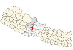
Parbat District (Nepali: पर्वत जिल्ला![]()
Geography and climate
Parbat district is a beautiful district with diversified geographical features. It extends from 280 00’ 19" N to 280 23’ 59" N latitude and 830 33’ 40" E to 830 49’ 30" E longitude
| Climate Zone[1] | Elevation Range | % of Area |
|---|---|---|
| Upper Tropical | 300 to 1,000 meters 1,000 to 3,300 ft. |
17.8% |
| Subtropical | 1,000 to 2,000 meters 3,300 to 6,600 ft. |
66.9% |
| Temperate | 2,000 to 3,000 meters 6,400 to 9,800 ft. |
14.0% |
| Subalpine | 3,000 to 4,000 meters 9,800 to 13,100 ft. |
1.4% |
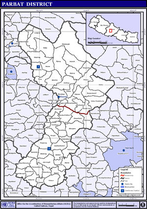
Political division
Entire Parbat district which had earlier 55 VDCs is now divided into 2 municipalities and 5 rural municipalities (gaunpalika) as listed below:
- Kusma Municipality
- Phalewas municipality
- Jaljala Rural Municipality
- Paiyun Rural Municipality
- Mahashila Rural Municipality
- Modi Rural Municipality
- Bihadi Rural Municipality
Village development committees (VDCs) and municipalities
- Arthar Dadakharka
- Bachchha
- Bahaki Thanti
- Bajung
- Balakot
- Banau
- Baskharka
- Behulibas
- Bhangara
- Bhoksing
- Bhorle
- Bhuk Deurali
- Bhuktangle
- Bihadi Barachaur
- Bihadi Ranipani
- Pipaltari
- Chitre
- Chuwa
- Deupurkot
- Deurali
- Devisthan
- Dhairing
- Durlung
- Hosrangdi
- Huwas
- Karkineta
- Katuwa Chaupari
- Khola Lakuri
- Khurkot
- Kurgha
- Kushma Municipality
- Kyang
- Lekhphant
- Limithana
- Lunkhu Deurali
- Mallaj Majhphant
- Mudikuwa
- Nagliwang
- Pakhapani
- Pakuwa
- Pang
- Pangrang
- Phalamkhani
- Phalebas Devisthan
- Phalebas Khanigaun
- Ramja Deurali
- Saligram
- Salija
- Saraukhola
- Shankar Pokhari
- Shivalaya
- Taklak
- Tanglekot
- Thana Maulo
- Thapathana
- Thuli Pokhari
- Tilahar
- Tribeni
- Urampokhara
- Wahakithanti
- 7 Palika
See also
References
- ↑ The Map of Potential Vegetation of Nepal - a forestry/agroecological/biodiversity classification system (PDF), Forest & Landscape Development and Environment Series 2-2005 and CFC-TIS Document Series No.110., 2005, ISBN 87-7903-210-9, retrieved Nov 22, 2013
- "Districts of Nepal". Statoids.
External links
| Province No. 1 |  | |
|---|---|---|
| Province No. 2 | ||
| Province No. 3 | ||
| Gandaki Pradesh | ||
| Province No. 5 | ||
| Karnali Pradesh | ||
| Sudurpashchim Pradesh | ||
Coordinates: 28°14′0″N 83°31′0″E / 28.23333°N 83.51667°E
| Wikimedia Commons has media related to Parbat District. |