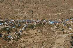
Mugu District
| Mugu District मुगु | |
|---|---|
| District | |
 | |
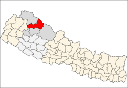 | |
| Country | Nepal |
| Province | Karnali Pradesh |
| Admin HQ. | Gamgadhi (today part of Chhayanath Rara Municipality) |
| Government | |
| • Type | Coordination committee |
| • Body | DCC, Mugu |
| Area | |
| • Total | 3,535 km2 (1,365 sq mi) |
| Population (2011) | |
| • Total | 55,286 |
| • Density | 16/km2 (41/sq mi) |
| Time zone | UTC+5:45 (NPT) |
Mugu District (Nepali: मुगु जिल्ला![]()
Geography and climate
Mugu's geography is very rugged. The biggest lake in Nepal, Rara Lake, also known as Mahendra Daha, lies in Mugu District.
It is one of the biggest districts of Nepal. Pulu is one of the famous village development committees (VDC) of Mugu district. There are many villages in this VDC, such as Riusa, Mooh, Mangri, Serog, and Dawra. Similarly, Seri Village Development Committee (VDC) is one of the famous VDCs of the district. It is located west of Rara VDC.
| Climate zone[2] | Elevation range | % of area |
|---|---|---|
| Subtropical | 1,000 to 2,000 meters 3,300 to 6,600 ft. |
5.6% |
| Temperate | 2,000 to 3,000 meters 6,400 to 9,800 ft. |
19.3% |
| Subalpine | 3,000 to 4,000 meters 9,800 to 13,100 ft. |
20.6% |
| Alpine | 4,000 to 5,000 meters 13,100 to 16,400 ft. |
17.7% |
| Nival | above 5,000 meters | 5.3% |
| Trans-Himalayan[3] | 3,000 to 6,400 meters 9,800 to 21,000 ft. |
31.2% |
Tourism
The remote Mugu district is rich in natural resources. Nepal's largest Rara Lake lies in this district. Many domestic and international tourists come to visit the famous and beautiful Rara Lake. The lake is also known as the Mahendra Tal. The Lake lies at an elevation of 2,990 meters and covers about 10.8 km2 of area. The Rara National Park protects and surrounds it.
Administration
The district consists of nine municipalities, out of which all are rural municipalities. These are as follows:[5]
- Chhayanath Rara Municipality
- Mugum Karmarong Rural Municipality
- Soru Rural Municipality
- Khatyad Rural Municipality
Former village development committees
Prior to the restructuring of the district, Mugu District consisted of the following municipalities and village development committees:

References
- ↑ "National Population and Housing Census 2011 (National Report)" (PDF). Central Bureau of Statistics. Archived from the original (PDF) on 2013-05-25. Retrieved 1 November 2012.
- ↑ The Map of Potential Vegetation of Nepal - a forestry/agroecological/biodiversity classification system (PDF), Forest & Landscape Development and Environment Series 2-2005 and CFC-TIS Document Series No.110., 2005, ISBN 87-7903-210-9, retrieved Nov 22, 2013
- ↑ Shrestha, Mani R.; Rokaya, Maan B.; Ghimire, Suresh K. (2005). "Vegetation pattern of Trans-Himalayan zone in the North-West Nepal". Nepal Journal of Plant Sciences. 1: 129–135. Retrieved Feb 7, 2014.
- ↑ Banerji, Gargi; Basu, Sejuti. "Climate Change and Himalayan Cold Deserts: Mapping vulnerability and threat to ecology and indigenous livelihoods" (PDF). Pragya. Gurgaon, Haryana, India. Retrieved February 7, 2014.
- ↑ "स्थानिय तह" (in Nepali). Ministry of Federal Affairs and General Administration. Retrieved 1 September 2018.
- "Districts of Nepal". Statoids.
Places adjacent to Mugu District | ||||||||||
|---|---|---|---|---|---|---|---|---|---|---|
| ||||||||||
Headquarters: Gamgadhi (today part of Chhayanath Rara Municipality) | ||
| Municipalities | | |
| Rural municipalities |
| |
| Former VDCs | ||
List of municipalities and rural municipalities of Nepal | ||
| Province No. 1 |  | |
|---|---|---|
| Province No. 2 | ||
| Province No. 3 | ||
| Gandaki Pradesh | ||
| Province No. 5 | ||
| Karnali Pradesh | ||
| Sudurpashchim Pradesh | ||
Coordinates: 29°33′N 82°10′E / 29.550°N 82.167°E
| Wikimedia Commons has media related to Mugu District. |