Western Rukum District
| Western Rukum District पश्चिमी रुकुम | |
|---|---|
| District | |
 | |
| Coordinates: 28°38′N 82°29′E / 28.63°N 82.49°ECoordinates: 28°38′N 82°29′E / 28.63°N 82.49°E | |
| Country | Nepal |
| Province | Karnali Pradesh |
| Established | 2015 |
| Government | |
| • Type | Coordination committee |
| • Body | DCC, Western Rukum |
| Area | |
| • Total | 1,213.49 km2 (468.53 sq mi) |
| Population | |
| • Total | 154,272 |
| Time zone | UTC+5:45 (NPT) |
| Website | http://www.ddcrukum.gov.np/ |
Western Rukum (Nepali: पश्चिमी रुकुम) a part of Karnali province, is one of the seventy-seven districts of Nepal.[1] Musikot is the headquarter of the district.
Formally Western Rukum District was part of Rukum District, which divided into two districts Western Rukum and Eastern Rukum after the state's reconstruction of administrative divisions as of 20 September 2015.
The total area of Western Rukum District is 1,213.49 square kilometres (468.53 sq mi) and total population of this district as of 2011 Nepal census is 154,272 individuals. [1] [2]
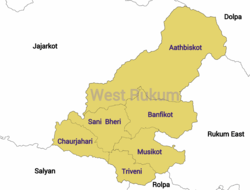
Divisions
The district is divided into 3 urban municipalities and 3 rural municipalities [1][3]
Urban municipalities
Rural municipalities
- Banphikot,west Rukum
- Tribeni
- Sani Bheri
See also
References
- 1 2 3 "स्थानीय तहहरुको विवरण" [Details of local level body]. www.mofald.gov.np (in Nepali). Ministry of Federal Affairs and Local Development (Nepal). Retrieved 14 April 2018.
- ↑ "CITY POPULATION– statistics, maps & charts". www.citypopulation.de. 8 October 2017. Retrieved 14 April 2018.
- ↑ "District Corrected Last for RAJAPATRA" (PDF). www.mofald.gov.np. Ministry of Federal Affairs and Local Development (Nepal). Retrieved 14 April 2018.
External links

This article is issued from
Wikipedia.
The text is licensed under Creative Commons - Attribution - Sharealike.
Additional terms may apply for the media files.