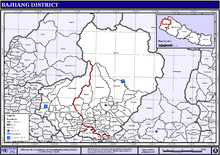
Bajhang District
| Bajhang District बझाङ | |
|---|---|
| District | |
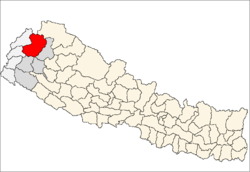 | |
| Country | Nepal |
| Province | Province No. 7 |
| Admin HQ. | Chainpur (today part of Jaya Prithvi Municipality) |
| Government | |
| • Type | Coordination committee |
| • Body | DCC, Bajhang |
| Area | |
| • Total | 3,422 km2 (1,321 sq mi) |
| Population (2011) | |
| • Total | 195,159[1] |
| Time zone | UTC+5:45 (NPT) |
| Main Language(s) | Bajhangi, Nepali |
Bajhang District (Nepali: बझाङ जिल्ला ![]()
Geography and Climate
| Climate Zone[2] | Elevation Range | % of Area |
|---|---|---|
| Upper Tropical | 300 to 1,000 meters 1,000 to 3,300 ft. |
0.5% |
| Subtropical | 1,000 to 2,000 meters 3,300 to 6,600 ft. |
18.0% |
| Temperate | 2,000 to 3,000 meters 6,400 to 9,800 ft. |
26.5% |
| Subalpine | 3,000 to 4,000 meters 9,800 to 13,100 ft. |
16.6% |
| Alpine | 4,000 to 5,000 meters 13,100 to 16,400 ft. |
8.4% |
| Nival | above 5,000 meters | 30.0% |
Major religious spots
1. Khaptad baba mandir
2. Ram mandir, Kada
3. Surma sarowar, Surma
Administration
The district consists of twelve municipalities, out of which two are urban municipalities and ten are rural municipalities. These are as follows:[3]
- Jaya Prithvi Municipality
- Bungal Municipality
- Talkot Rural Municipality
- Masta Rural Municipality
- Khaptadchhanna Rural Municipality
- Thalara Rural Municipality
- Bitthadchir Rural Municipality
- Surma Rural Municipality
- Chhabispathiver Rural Municipality
- Durgathali Rural Municipality
- Kedarsyu Rural Municipality
- Kanda Rural Municipality
Prior to the restructuring of the district, Bajhang District consisted of the following municipalities and Village development committees:
- Banjh
- Bagthala
- Bhairabnath
- Bhamchaur
- Bhatekhola
- Byasi
- Chaudhari
- Dahabagar
- Dangaji
- Dantola
- Daulichaur
- Deulekh
- Deulikot
- Dhamena
- Gadaraya
- Jaya Prithvi Municipality
- Kadal
- Kailash
- Kalukheti
- Kanda
- Kaphalaseri
- Khiratadi
- Koiralakot
- Kot Bhairab
- Kotdewal
- Lamatola
- Lekhgaun
- Majhigaun
- Malumela
- Mashdev
- Matela
- Maulali
- Melbisauni
- Parakatne
- Patadewal
- Pauwagadhi
- Pitatola
- Pipalkot
- Rayal
- Rilu
- Sainpasela
- Sunikot
- Sunkuda
- Surma
- Syandi
- Thalara
See also
- Jaya prithvi bahadur singh
- Zones of Nepal
- "Districts of Nepal". Statoids.
References
- 1 2 "National Population and Housing Census 2011(National Report)" (PDF). Central Bureau of Statistics. Government of Nepal. November 2012. Archived from the original (PDF) on 2013-04-18. Retrieved November 2012. Check date values in:
|accessdate=(help) - ↑ The Map of Potential Vegetation of Nepal - a forestry/agroecological/biodiversity classification system (PDF), . Forest & Landscape Development and Environment Series 2-2005 and CFC-TIS Document Series No.110., 2005, ISBN 87-7903-210-9, retrieved Nov 22, 2013
- ↑ "स्थानिय तह" (in Nepali). Ministry of Federal Affairs and General Administration. Retrieved 1 September 2018.
| Wikimedia Commons has media related to Bajhang District. |
Places adjacent to Bajhang District | ||||||||||
|---|---|---|---|---|---|---|---|---|---|---|
| ||||||||||
| Province No. 1 |  | |
|---|---|---|
| Province No. 2 | ||
| Province No. 3 | ||
| Gandaki Pradesh | ||
| Province No. 5 | ||
| Karnali Pradesh | ||
| Sudurpashchim Pradesh | ||
Coordinates: 29°33′N 81°12′E / 29.550°N 81.200°E