Kanchanpur District
| Kanchanpur District कञ्चनपुर जिल्ला | |
|---|---|
| District | |
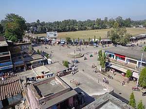 Madan Chowk at Bhimdatta municipality | |
 | |
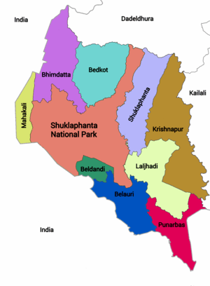 Divisions of Kanchanpur District | |
| Country | Nepal |
| Province | Province No. 7 |
| Established | 1860 |
| Admin HQ. | Mahendranagar |
| Municipality | |
| Government | |
| • Type | Coordination committee |
| • Body | DCC, Kanchanpur |
| • Head | Mr. Phairu Tamang |
| • Deputy-Head | Mrs. Sanu Kumari Budthapa |
| Area | |
| • Total | 1,610 km2 (620 sq mi) |
| Population (2011) | |
| • Total | 451,248 |
| • Density | 280/km2 (730/sq mi) |
| Time zone | UTC+5:45 (NPT) |
| Main Language(s) | Doteli(70%), Rana Tharu (20%), Nepali language (7%), others (3%) |
| Website |
ddckanchanpur |
Kanchanpur District (Nepali: कञ्चनपुर जिल्ला![]()
Before the reunification of Nepal by Gorkha King PN Shah, this district was the part of Doti Kingdom. Nepal lost it to the East India Company after Anglo-Nepalese war (1814-1816) between the then Kingdom of Nepal and East India Company followed by territorial concessions of Sugauli Treaty.[3] Later on after treaty of 1860, Nepal recovered this land along with Kailali, Banke and Bardiya. Its first headquarters was Belauri Municipality and the current headquarter Mahendranagr was declared in 2019 B.S.
The majority of population is occupied by ethnic Tharu community and minor group are the peoples that have migrated from northern hilly region. The district is renowned for Shuklaphanta Wildlife Reserve and 1,456.97 metres (4,780 ft) long multispan suspension bridge over Mahakali River.
Jhilmila Lake, Bedkot Lake, Bandatal, Shovatal and Vishnu Temple,Ranital are the other places of tourist attraction.
Geography
It expands from 28 degree 38 minutes to 29 degree 28 minutes Northern latitudes and 80 degree 03 minutes to 80 degree 33 minutes Eastern Longitudes.[4] It is situated at the end of westmost part of province and country on the corner of south-west. Geographically it is on the terai but the northern part of the district has some higher altitudes of elevation. The highest elevation of the district is 1528m and lowest is 176m. Main rivers of the region are Mahakali, Jobuda, Chaudhar, Mohana, Syali, Banhara, Sanbora and Doda[5]
| Climate Zone[6] | Elevation Range | % of Area |
|---|---|---|
| Lower Tropical | below 300 m (1,000 ft) | 85.2% |
| Upper Tropical | 300 to 1,000 m (1,000 to 3,300 ft) | 13.0% |
| Subtropical | 1,000 to 2,000 m (3,300 to 6,600 ft) | 1.8% |
Divisions
Kanchanpur district is divided into 7 municipalities and 2 rural municipalities:
- Municipalities
- Rural municipalities
- Laljhadi
- Beldandi
Communication and Media
Online News Portal, FM Stations and News Papers of Kanchanpur District
- NB Media Network[7]
- Suklaphanta FM 99.4 MHz[8]
- Radio Mahakali FM 96.2 MHz[9]
- Radio Belauri 105 MHz[10]
- Belauri Post Weekly
- Dishanirdesh Kanchan Post Weekly
- Farwest Times
- Chure Times
- Mahendranagar Post
- Abhiyan Daily
- Paschim Nepal Daily
- Dainik Khabar Daily
- New Janakranti Daily
- Radio Nagarik FM 104.3 MHz[11]
- Radio Rastriya 89.8 MHz[12]
- Radio Barasinga 102.2 MHz
- Radio Paschim Nepal 91.0 MHz
- Radio Kanchanpur 90.2 MHz[13]
- Radio Pahichaan FM 105.3 MHz
- Radio Sudur Sanchar 100.4 MHz[14]
- Radio Jhalari FM 105.9 MHz[15]
- Prabhu FM 102.5 MHz
Lakes In Kanchanpur District
- Banda lake
- Betkot lake
- Pyara lake
- Jhilmila lake
- Shova lake
- Shuklaphanta lake
- Ranital
References
- ↑ "National Population and Housing Census 2011(National Report)" (PDF). Central Bureau of Statistics. Government of Nepal. November 2012. Archived from the original (PDF) on 18 April 2013. Retrieved 28 July 2015.
- ↑ "Districts of Nepal (Population, Area & Capital)". Statoids. 7 December 2012. Retrieved 7 December 2012.
- ↑ "History of Nepal Army". Official website of Nepal Army.
- ↑ "District Development Committee, Kanchanpur".
- ↑ "कंचनपुर जिल्लाकाे संक्षिप्त परिचय" [Short introduction of Kanchanpur district]. www.ddckanchanpur.gov.np (in Nepali). Retrieved 22 August 2018.
- ↑ The Map of Potential Vegetation of Nepal - a forestry/agroecological/biodiversity classification system (PDF), Forest & Landscape Development and Environment Series 2-2005 and CFC-TIS Document Series No.110., 2005, ISBN 87-7903-210-9, retrieved Nov 22, 2013
- ↑ "nbkhabar.com".
- ↑ "Suklaphanta FM 99.4 MHz".
- ↑ "Radio Mahakali FM 96.2 MHz".
- ↑ "Radio Belauri 105 MHz".
- ↑ "Radio Nagarik FM 104.3 MHz".
- ↑ "Radio Rastriya 89.8 MHz".
- ↑ "Radio Kanchanpur 90.2 MHz".
- ↑ "Radio Sudur Sanchar 100.4 MHz".
- ↑ "Radio Jhalari FM 105.9 MHz".
External links
| Wikimedia Commons has media related to Kanchanpur District. |
Coordinates: 28°50′N 80°20′E / 28.833°N 80.333°E
Places adjacent to Kanchanpur District | |
|---|---|
Headquarters: Bhimdatta | ||
| Municipalities | | |
| Rural municipalities |
| |
| Former VDCs | ||
List of municipalities and rural municipalities of Nepal | ||
