Kapilvastu District
| Kapilvastu District कपिलवस्तु जिल्ला | |
|---|---|
| District | |
 | |
| Country | Nepal |
| Government | |
| • Type | Coordination committee |
| • Body | DCC, Kapilvastu |
| Area | |
| • Total | 1,738 km2 (671 sq mi) |
| Population (2011) | |
| • Total | 571,936 |
| • Density | 330/km2 (850/sq mi) |
| Time zone | UTC+5:45 (NPT) |
| Main Language(s) | Awadhi, Tharu, Urdu, Nepali |
| Website |
www |
Kapilvastu district (Nepali: कपिलवस्तु जिल्ला![]()
Geography and climate
The district is situated at a height of 93 to 1,491 metres (305 to 4,892 ft) above sea level.[1] Geographically, the district can be divided into the low land plains of Terai and the low Chure hills.
Kapilvastu is bounded by Rupandehi District to the east, Dang Deukhuri District in Rapti zone to the northwest, Arghakhanchi District to the north, Balrampur district, Awadh region, Uttar Pradesh, India to the west and Siddharthnagar district, Purvanchal region, Uttar Pradesh to the south.
| Climate zone[2] | Elevation range | % of area |
|---|---|---|
| Lower Tropical | below 300 meters (1,000 ft) | 86.8% |
| Upper Tropical | 300 to 1,000 meters 1,000 to 3,300 ft. |
12.0% |
| Subtropical | 1,000 to 2,000 meters 3,300 to 6,600 ft. |
1.2% |
The summer is hot with temperature above 27 °C and winter temperature remains below 15 °C. Due to extremely hot and cold climatic conditions, the people suffer from viral fever, dengo , maleria etc and cold and diarrohea respectively.
Demographics
According to the 2001 census, the major ethnic groups in this district are[3] Nepali (90%) and Indians (10%).
The 2011 census found that 90% of people in the district were Awadhi speakers followed by, Tharu (5%) and (5%) are native Nepali speakers. The number of immigrants from the neighboring hilly region is increasing every year. The major caste of the district is Muslim.
Administrative Divisions
See latest division here.
http://www.election.gov.np/ecn/uploads/userfiles/maps/KAPILBASTU.pdf
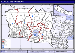
Municipalities
Kapilvastu Municipality
Banganga Municipality
Buddhabhumi Municipality
Shivaraj Municipality
Krishnanagar Municipality
Maharajgunj Municipality
Rural Municipality
Mayadevi Rural Municipality
Yashodhara Rural Municipality
Suddhodhan Rural Municipality
Bijaynagar Rural Municipality
Economy
Most of the population of the district is dependent on agriculture. Paddy rice is a major crop of the district. A number of youths rely on foreign employment while sugarcane is an important cash crop.
| Crop | Production in metric tonnes |
|---|---|
| Paddy | > 150,000 |
| Wheat | 25,000-35,000 |
| Sugarcane | > 175,000 |
| Oil seed | 1,000-5,000 |
Population
At the time of 2011 A.D National population and Housing census 2011 was reported that total population of kapilvastu district was 571,936 . Male=285,599 and Female=286,337 and number of total household was 91,321 Data source: central bureau of statistics, kathmandu government of Nepal .
Culture
Awadhi people are the major inhabitants of this region, which is very rich in their culture. Awadhi cuisine is well known. As majority of the population are Muslims, they celebrate Eid(Eid-ul-fitre) and Bakrid( Eid-ul-Adha). Tharu people living in the western part of the district have their own distinct culture. The main culture of Tharu is Maghi. Most of the people in Kapilvastu district are migrated from Arghakhanchhi district and few are from the rest of the districts of Lumbini zone. The hindus from the hilly and the permanent local people of the district, specially Brahmin celebrate the festivals like Dashain, Tihar, Janai purnima,Holi etc. According to the local grandfather well known at शिवराज नगरपालिका named खिमलाल, it was the district filled with Muslims and Tharu only.
Places of interest
World Marsh Region
A region with biodiversity, cultural, archaeological and historical monuments that has been proposed to be enlisted in the list of World Cultural Heritage of UNESCO.
Archaeological sites
More than 138 historical sites related to Buddha have already been identified within the boundary to the east of Banganga, west of Kothi, north to Indian border and south to Mahendra highway. The forest of the district stands as a natural park. The land is irrigated by the rivers like Banganga, Koili, Surai, Chirai, Bhutera and others.[1]
See also
References
- 1 2 http://www.ddckapilvastu.gov.np/DDCKapilvastu/aboutkapilvastu.htm. Retrieved October 7, 2008. Missing or empty
|title=(help) - ↑ The Map of Potential Vegetation of Nepal - a forestry/agroecological/biodiversity classification system (PDF), Forest & Landscape Development and Environment Series 2-2005 and CFC-TIS Document Series No.110., 2005, ISBN 87-7903-210-9, retrieved November 22, 2013
- ↑ Population Monograph of Nepal, Volume I
External links
- "Districts of Nepal". Statoids.

| Province No. 1 |  | |
|---|---|---|
| Province No. 2 | ||
| Province No. 3 | ||
| Gandaki Pradesh | ||
| Province No. 5 | ||
| Karnali Pradesh | ||
| Sudurpashchim Pradesh | ||
Coordinates: 27°32′N 83°3′E / 27.533°N 83.050°E
| Wikimedia Commons has media related to Kapilvastu District. |