Gokarneshwar
| Gokarneshwar Municipality गोकर्णेश्वर नगरपालिका | |
|---|---|
| Municipality | |
 Gokarna Mahadev Temple | |
 Gokarneshwar Municipality Location in Nepal | |
| Coordinates: 27°44′0″N 85°23′0″E / 27.73333°N 85.38333°ECoordinates: 27°44′0″N 85°23′0″E / 27.73333°N 85.38333°E | |
| Country |
|
| Province | No. 3 |
| District | Kathmandu District |
| Established | 2014 |
| Government | |
| • Mayor | Santosh Chalise (NC) |
| • Deputy Mayor | Shanti Nepal (NC) |
| Area | |
| • Total | 58.5 km2 (22.6 sq mi) |
| Population (2011 Nepal census) | |
| • Total | 107,351 |
| • Density | 1,800/km2 (4,800/sq mi) |
| • Ethnicities | Newar, Bahun, Chhetri, Tamang, Magar |
| Time zone | UTC+5:45 (NST) |
| Website |
gokarneshwormun |
Gokarneshwar is a municipality in Kathmandu District in the Province No. 2 of Nepal that was established on 2 December 2014 by merging the former Village development committees Sundarijal, Nayapati, Baluwa, Jorpati and Gokarna.[1][2] The office of the municipality is that of the former Jorpati village development committee.
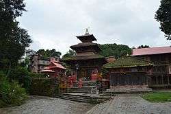
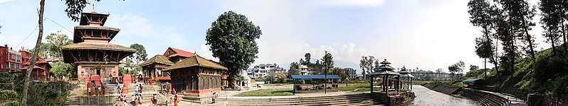
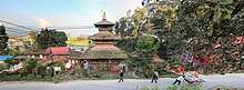
In the village on the banks of the Bagmati River stands the Gokarna Mahadev temple, built in 1582.[3] In late August or early September people go to this temple to bathe and make offerings in honor of their fathers, living or dead, on a day called Gokarna Aunsi.[4]
The Gokarna Forest Reserve is located in the area. Nepal Medical College and Teaching Hospital is located Southwest of Gokarneshwar.
Population
Gokarneshwar municipality has a total population of 107,351 according to 2011 Nepal census.[5] At the time of the 2011 Nepal census the village had a population of 7,508 with 1,768 households.[6]
Notable residents
Writer Ramesh Bikal was born near Gokarna in 1932.[7]
Gallery
References
- ↑ "Govt announces 61 municipalities". The Kathmandu Post. 3 December 2014. Retrieved 2 December 2014.
- ↑ "Govt creates 61 new municipalities". República. 3 December 2014. Retrieved 2 December 2014.
- ↑ B. Mayhew, J. Bindloss, and S. Armington (2006). Nepal. 7th Edition, Lonely Planet. ISBN 1-74059-699-4
- ↑ David Reed; James McConnachie (2002), The rough guide to Nepal, Rough Guide Travel Guides (5, illustrated ed.), Rough Guides, pp. 188, 204, ISBN 9781858288994
- ↑ "2011 Nepal census (Ward Level)" (PDF). Central Bureau of Statistics. November 2012. Archived from the original (PDF) on 2013-07-31. Retrieved November 2012. Check date values in:
|accessdate=(help) - ↑ Government of Nepal, National Planning Commission Secretariat, Central Bureau of Statistics (November 2012). National Population and Housing Census 2011 (Village Development Committee/Municipality) (PDF). 02, NPHC 2011. Kathmandu. Archived from the original (PDF) on 2013-09-27. Retrieved 2014-07-10.
- ↑ Himalayan Voices: An Introduction to Modern Nepali Literature (Voices from Asia), edited and translated by Michael J. Hutt, University of California Press, 1991. p. 244. ISBN 9780520910263
External links
Headquarter: Kathmandu | |||
 |  | ||