Cabarroguis, Quirino
| Cabarroguis | ||
|---|---|---|
| Municipality | ||
| Municipality of Cabarroguis | ||
 Saint Mark Parish Church | ||
| ||
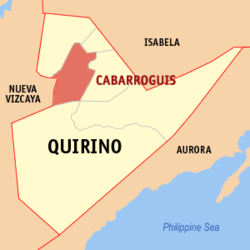 Map of Quirino with Cabarroguis highlighted | ||
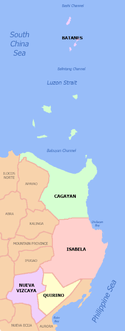
.svg.png) Cabarroguis Location within the Philippines | ||
| Coordinates: 16°35′00″N 121°30′00″E / 16.58333°N 121.5°ECoordinates: 16°35′00″N 121°30′00″E / 16.58333°N 121.5°E | ||
| Country |
| |
| Region | Cagayan Valley (Region II) | |
| Province | Quirino | |
| District | Lone District | |
| Barangays | 17 (see Barangays) | |
| Government [1] | ||
| • Type | Sangguniang Bayan | |
| • Mayor | Avelino N. Agustin Jr. | |
| • Electorate | 17,067 voters (2016) | |
| Area [2] | ||
| • Total | 260.20 km2 (100.46 sq mi) | |
| Population (2015 census)[3] | ||
| • Total | 30,582 | |
| • Density | 120/km2 (300/sq mi) | |
| Time zone | UTC+8 (PST) | |
| ZIP code | 3400 | |
| PSGC | 025702000 | |
| IDD : area code | +63 (0)78 | |
| Climate type | Tropical rainforest climate | |
| Income class | 3rd municipal income class | |
| Revenue (₱) | 134,660,080.64 (2016) | |
| Native languages |
Ilocano Ilongot Tagalog | |
| Website |
www | |

Cabarroguis, officially the Municipality of Cabarroguis, is a 3rd class municipality and capital of the province of Quirino, Philippines. According to the 2015 census, it has a population of 30,582 people.[3]
Barangays
Cabarroguis is politically subdivided into 17 barangays.
Demographics
| Population census of Cabarroguis | ||
|---|---|---|
| Year | Pop. | ±% p.a. |
| 1970 | 7,838 | — |
| 1975 | 12,226 | +9.33% |
| 1980 | 17,450 | +7.37% |
| 1990 | 21,793 | +2.25% |
| 1995 | 22,812 | +0.86% |
| 2000 | 25,832 | +2.70% |
| 2007 | 28,024 | +1.13% |
| 2010 | 29,395 | +1.75% |
| 2015 | 30,582 | +0.76% |
| Source: Philippine Statistics Authority[3] [4] [5] [6] | ||
References
- ↑ "Municipality". Quezon City, Philippines: Department of the Interior and Local Government. Retrieved 31 May 2013.
- ↑ "Province: Quirino". PSGC Interactive. Quezon City, Philippines: Philippine Statistics Authority. Retrieved 12 November 2016.
- 1 2 3 Census of Population (2015). "Region II (Cagayan Valley)". Total Population by Province, City, Municipality and Barangay. PSA. Retrieved 20 June 2016.
- ↑ Census of Population and Housing (2010). "Region II (Cagayan Valley)". Total Population by Province, City, Municipality and Barangay. NSO. Retrieved 29 June 2016.
- ↑ Censuses of Population (1903–2007). "Region II (Cagayan Valley)". Table 1. Population Enumerated in Various Censuses by Province/Highly Urbanized City: 1903 to 2007. NSO.
- ↑ "Province of Quirino". Municipality Population Data. Local Water Utilities Administration Research Division. Retrieved 17 December 2016.
External links
| Wikimedia Commons has media related to Cabarroguis, Quirino. |
- Cabarroguis.gov.ph
- QuirinoProvince.org
- Philippine Standard Geographic Code
- Philippine Census Information
- Local Governance Performance Management System
Places adjacent to Cabarroguis, Quirino | ||||||||||
|---|---|---|---|---|---|---|---|---|---|---|
| ||||||||||
This article is issued from
Wikipedia.
The text is licensed under Creative Commons - Attribution - Sharealike.
Additional terms may apply for the media files.