Josefina, Zamboanga del Sur
| Josefina | |
|---|---|
| Municipality | |
| Municipality of Josefina | |
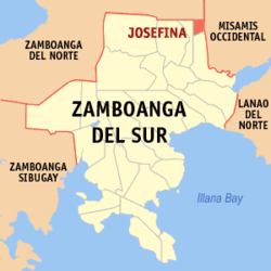
 Map of Zamboanga del Sur with Josefina highlighted | |
.svg.png) Josefina Location within the Philippines | |
| Coordinates: 8°12′N 123°32′E / 8.2°N 123.53°ECoordinates: 8°12′N 123°32′E / 8.2°N 123.53°E | |
| Country |
|
| Region | Zamboanga Peninsula (Region IX) |
| Province | Zamboanga del Sur |
| District | 1st District |
| Founded | November 11, 1977 |
| Barangays | 14 (see Barangays) |
| Government [1] | |
| • Type | Sangguniang Bayan |
| • Mayor | Maria Fe M. Pitogo |
| • Electorate | 6,462 voters (2016) |
| Area [2] | |
| • Total | 56.35 km2 (21.76 sq mi) |
| Population (2015 census)[3] | |
| • Total | 11,799 |
| • Density | 210/km2 (540/sq mi) |
| Time zone | UTC+8 (PST) |
| ZIP code | 7027 |
| PSGC | 097337000 |
| IDD : area code | +63 (0)62 |
| Climate type | Tropical climate |
| Income class | 5th municipal income class |
| Revenue (₱) | 52,639,866.66 (2016) |
| Native languages |
Subanon language Cebuano Chavacano Tagalog |
| Website |
www |
Josefina, officially the Municipality of Josefina, is a 5th class municipality in the province of Zamboanga del Sur, Philippines. According to the 2015 census, it has a population of 11,799 people.[3]
Barangays
Josefina is politically subdivided into 14 barangays.
History
In the early years the lands of which is now Josefina was part of the Municipality of Aurora. In later years, Molave separated from Aurora and became a town; at that time Tambulig and the area now within the jurisdiction of the present municipality were still part of the former. Some years later Tambulig became independent and was recognized as a township with the land of Josefina still tagged as part of its territories. During this time the first Visayan settlers came to live in the area. These settlers came from Tudela, Misamis Occidental, a barrio part of Tambulig was established and was named Bagong Tudela.
Some years passed and the Paredes family, one of the first settlers, was able to acquire properties there and named it "Salug Estate". A member of the family was a rubber technologist at that time and worked in Borneo. He brought along his lessons and expertise and together with the locals, "the Subanen", planted his land with Rubber Trees. By then the Rubber Technologist, Nicholas Paredes, coined the name "New Town" for the new rubber plantation.
With the rubber plantation, the place was then locally called as "Gumahan". This became a new trading center and small businesses came bustling. With the increased activity in this new location it was then christened as "Upper Bagong Tudela". This eventually became the center of the new community.
In the early 1970s, the people of Gumahan and its outlying barrios made a move, through the leadership of Nicholas Paredes, to create a town. They were able to submit the proposal to congress, through the sponsorship of then Cong. Cerilles, and it passed the 2nd congressional reading. When scheduled for the 3rd and final congressional reading, Martial Law was declared dissolving the Congress.
On November 11, 1978, by virtue of Presidential Decree 1240, 13 barangays of Tambulig were separated and formed into the independent municipality Josefina.[4] During this time Nicholas Paredes (who was the point person of the township proposal) stood as the first Mayor (appointed). Mayor Paredes donated the land where now stands the Market Area, the school, the Municipal Hall and the Catholic Church. The town center is also located within the properties of the Paredes family.
As to this day Josefina is still commonly known as "Gumahan".
Demographics
| Population census of Josefina | ||
|---|---|---|
| Year | Pop. | ±% p.a. |
| 1980 | 6,755 | — |
| 1990 | 7,591 | +1.17% |
| 1995 | 9,024 | +3.29% |
| 2000 | 8,758 | −0.64% |
| 2007 | 10,796 | +2.93% |
| 2010 | 10,826 | +0.10% |
| 2015 | 11,799 | +1.65% |
| Source: Philippine Statistics Authority[3][5][6][7] | ||
References
- ↑ "Municipality". Quezon City, Philippines: Department of the Interior and Local Government. Retrieved 31 May 2013.
- ↑ "Province: Zamboanga del Sur". PSGC Interactive. Quezon City, Philippines: Philippine Statistics Authority. Retrieved 12 November 2016.
- 1 2 3 Census of Population (2015). "Region IX (Zamboanga Peninsula)". Total Population by Province, City, Municipality and Barangay. PSA. Retrieved 20 June 2016.
- ↑ "Presidential Decree No. 1240: Creating the Municipality of Josefina in the Province of Zamboanga del Sur". The Lawphil Project. Arellano Law Foundation, Inc. Retrieved 21 July 2014.
- ↑ Census of Population and Housing (2010). "Region IX (Zamboanga Peninsula)". Total Population by Province, City, Municipality and Barangay. NSO. Retrieved 29 June 2016.
- ↑ Censuses of Population (1903–2007). "Region IX (Zamboanga Peninsula)". Table 1. Population Enumerated in Various Censuses by Province/Highly Urbanized City: 1903 to 2007. NSO.
- ↑ "Province of Zamboanga del Sur". Municipality Population Data. Local Water Utilities Administration Research Division. Retrieved 17 December 2016.