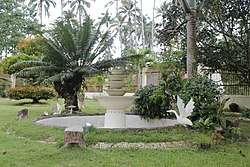
Buug, Zamboanga Sibugay
| Buug | |
|---|---|
| Municipality | |
| Municipality of Buug | |
 | |
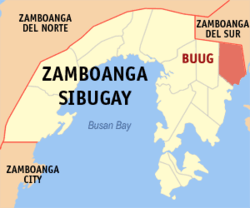 Map of Zamboanga Sibugay with Buug highlighted | |
.svg.png) Buug Location within the Philippines | |
| Coordinates: 7°44′N 123°04′E / 7.73°N 123.07°ECoordinates: 7°44′N 123°04′E / 7.73°N 123.07°E | |
| Country | Philippines |
| Region | Zamboanga Peninsula (Region IX) |
| Province | Zamboanga Sibugay |
| District | 1st District |
| Founded | 1960 |
| Barangays | 27 (see Barangays) |
| Government [1] | |
| • Type | Sangguniang Bayan |
| • Mayor | Jonam Ratilla Lagas |
| • Vice Mayor | Marvin Jessie Gonzales Gako |
| • Electorate | 22,271 voters (2016) |
| Area [2] | |
| • Total | 134.06 km2 (51.76 sq mi) |
| Elevation | 200 m (700 ft) |
| Population (2015 census)[3] | |
| • Total | 36,634 |
| • Density | 270/km2 (710/sq mi) |
| Time zone | UTC+8 (PST) |
| ZIP code | 7009 |
| PSGC | 098302000 |
| IDD : area code | +63 (0)62 |
| Climate type | Tropical climate |
| Income class | 3rd municipal income class |
| Revenue (₱) | 107,086,489.79 (2016) |
| Native languages |
Subanon language Cebuano Chavacano Tagalog |
| Website |
www |
Buug, officially the Municipality of Buug, is a 3rd class municipality in the province of Zamboanga Sibugay, Philippines. According to the 2015 census, it has a population of 36,634 people.[3]
Etymology
The name Buug was derived from the word bog, a Subanen word for second-growth forest which is the same as the Cebuano-Visayan term buog. Accordingly, a group of Subanens stumbled upon this bog that was endowed with a stream and sufficient supply of water while they were moving from one place to another in search of a safe place to start a living away from marauders who were in search for slaves and things to loot. From then on people began to refer to the bog as Buug.
Geography
Buug is located in the central Zamboanga Peninsula, on the island of Mindanao. It has a pentagon-like shape bounded on the south by Dumanquilas Bay, Bayog on the north, Kumalarang on the east, Diplahan on the west, and Malangas on south-west. The distance from Manila to Buug is approximately 790 kilometres (490 mi). It is five hours away from Zamboanga City via passenger bus, one hour and 45 minutes drive from the Ipil, the province's capital, and 57 kilometres (35 mi) away from Pagadian, or 45 minutes of travel by bus.
It has an average temperature of 26 °C (79 °F) and has an average elevation of 200 metres (660 ft) above sea level. It is away from the typhoon belt and enjoying a Type IV climate, i.e. rainfall is more or less evenly distributed throughout the year.
Barangays
Buug belongs to the first district of Zamboanga Sibugay. The local executive council is administered by a mayor. The legislative council is headed by a vice mayor with ten municipal councilors as members, eight of which are elected as is, one is the representative of Sangguniang Kabataan and the president of the Association of Barangay Captains (ABC). It is politically subdivided into 27 barangays.
- Agutayan
- Bagong Borbon
- Basalem
- Bawang
- Bliss
- Bulaan
- Compostela
- Danlugan
- Datu Panas
- Del Monte
- Guintuloan
- Guitom
- Guminta
- Labrador
- Lantawan
- Mabuhay
- Maganay
- Manlin
- Muyo
- Pamintayan
- Pling
- Poblacion
- Pulog
- San Jose
- Talairan
- Talamimi
- Villacastor (Galit)
History
Buug grew into a thriving community through the initiative of the timuays, the Subanen chieftains, who held leadership of the community. A school was opened which drew in the first trickle of Subanon, Cebuano, and Visayan settlers. When the Samar Mining Company (SAMICO) opened the Sibuguey project in 1957 at Bobuan (now part of the daughter municipality of Bayog), the next group of settlers flooded in. The same thing happened when the Pagadian-Zamboanga National Highway reached Buug in 1958.
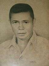
Buug was originally a barangay of the municipality of Margosatubig and became a baranggay of Malangas when the former was divided in 1951. It became a municipality through Executive Order No. 380 issued by President Carlos P. Garcia on February 2, 1960. Instrumental in the formation of Buug was the persistence and hard work of Quirino M. Gonzales, a fisherman who also was a councilor of Malangas and a native of Merida, Leyte. He is also a distant relative of then Senator Neptali Gonzales. Gonzales became the first appointed mayor and was called the Father of Buug. After being proclaimed as a municipality, flocks of settlers established residence and trade in the place.[4]
Demographics
| Population census of Buug | ||||||||||||||||||||||||||||||||||
|---|---|---|---|---|---|---|---|---|---|---|---|---|---|---|---|---|---|---|---|---|---|---|---|---|---|---|---|---|---|---|---|---|---|---|
|
| |||||||||||||||||||||||||||||||||
| Source: Philippine Statistics Authority[3] [5] [6] [7] | ||||||||||||||||||||||||||||||||||
Economy
Credit institutions and commercial businesses have multiplied. Appliance centers and merchandisers with main branches in big cities have invested in the area. Cottage industries have also sprouted. Buug’s economy is based on two sectors categorized by the local government:
- Agriculture which consists of farming, livestock & poultry, and fisheries.
- Service Activities such as trade/commerce & industry, finance, personal and community service.
Education
There are two colleges in Buug. One is the government-owned, Mindanao State University - Buug Campus which offers courses in education, liberal arts, agriculture, and aquaculture. It also has a high school which also serves as the laboratory school of the College of Education. The other is the privately owned and medically inclined St. John General Hospital and College, Inc. Another private school, managed by the Sisters of St. Paul of Chartres is also located here, the St. Paul School (formerly Holy Trinity Academy) which offers primary and high school education. The first high school which opened in Buug is Gabaldon Institute which is now called Western Mindanao Institute, another privately owned school. The first technical and vocational school which opened in buug year 2009 is INTERNACIONAL COLEGIO DE TECNOLOGIA (ICT) which offers courses in Electronics and Communication Technology, Electrical Technology, Information Technology, Hotel and Restaurant Management, Automotive and Metal Technology and now also offer SHS Grade-11 and Grade-12 courses offers in Academic Track in GAS and TVL Track in Industrial Arts strand, ICT strand, and Home Economics Strand. managed by ZALDY MASAYON GUMALANG the School President (SP-GUMALANG).
.
References
- ↑ "Municipality". Quezon City, Philippines: Department of the Interior and Local Government. Retrieved 31 May 2013.
- ↑ "Province: Zamboanga Sibugay". PSGC Interactive. Quezon City, Philippines: Philippine Statistics Authority. Retrieved 12 November 2016.
- 1 2 3 Census of Population (2015). "Region IX (Zamboanga Peninsula)". Total Population by Province, City, Municipality and Barangay. PSA. Retrieved 20 June 2016.
- ↑ Manlin, Alicia. "Municipality of Buug". Municipal Planning and Development Coordinator. Retrieved January 8, 2014.
- ↑ Census of Population and Housing (2010). "Region IX (Zamboanga Peninsula)". Total Population by Province, City, Municipality and Barangay. NSO. Retrieved 29 June 2016.
- ↑ Censuses of Population (1903–2007). "Region IX (Zamboanga Peninsula)". Table 1. Population Enumerated in Various Censuses by Province/Highly Urbanized City: 1903 to 2007. NSO.
- ↑ "Province of Zamboanga Sibugay". Municipality Population Data. Local Water Utilities Administration Research Division. Retrieved 17 December 2016.
External links
- Official Website of the Municipality of Buug
- Philippine Standard Geographic Code
- Philippine Census Information
Places adjacent to Buug, Zamboanga Sibugay | |
|---|---|