Katipunan, Zamboanga del Norte
| Katipunan | ||
|---|---|---|
| Municipality | ||
| Municipality of Katipunan | ||
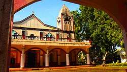 St.Francis Xavier Church | ||
| ||
| Nickname(s): Adventure Capital of Zamboanga del Norte | ||
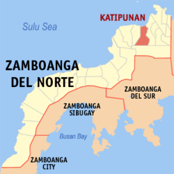 Map of Zamboanga del Norte with Katipunan highlighted | ||
.svg.png) Katipunan Location within the Philippines | ||
| Coordinates: 8°26′N 123°17′E / 8.43°N 123.28°ECoordinates: 8°26′N 123°17′E / 8.43°N 123.28°E | ||
| Country |
| |
| Region | Zamboanga Peninsula (Region IX) | |
| Province | Zamboanga del Norte | |
| District | 2nd District | |
| Founded | February 2, 1914 | |
| Barangays | 30 (see Barangays) | |
| Government [1] | ||
| • Type | Sangguniang Bayan | |
| • Mayor | Patchito Eguia | |
| • Electorate | 24,348 voters (2016) | |
| Area [2] | ||
| • Total | 244.12 km2 (94.26 sq mi) | |
| Population (2015 census)[3] | ||
| • Total | 45,577 | |
| • Density | 190/km2 (480/sq mi) | |
| Time zone | UTC+8 (PST) | |
| ZIP code | 7109 | |
| PSGC | 097203000 | |
| IDD : area code | +63 (0)65 | |
| Climate type | Tropical climate | |
| Income class | 2nd municipal income class | |
| Revenue (₱) | 81,848,181.53 (2016) | |
| Native languages |
Subanon language Cebuano Chavacano Tagalog | |
| Website |
katipunan | |

Katipunan, officially the Municipality of Katipunan, is a 2nd class municipality in the province of Zamboanga del Norte, Philippines. According to the 2015 census, it has a population of 45,577 people.[3]
It is formerly known as Lubungan.[4])
History
In 1955, six barrios were created:[5]
- sitios of Malobog, Malupis, Linasan Manok, Gakol, Gimakan, Lipakan and Capasi as barrio Denoman;
- sitios of Boalboal, Malonglong, Lobongpre, Nanginan Upper, Larang, Lowang, Lawag, Sibog, Lindangan, Gumatob and Lumbayao as barrio Pinialan;
- sitios of Baoy, Tamara, Tamilokan, Labokan, Sinilog, Grap, Tobod, Larang, Senuelan, Sibutak, Kunalog, Sapanaga and Upper Lipoga as barrio Nanginan;
- sitios of Depog, Mate, Saloyong, Lanasan, Notap, Balangasan, Masoy, Upper Seraboc, Dapitan, Linay, Baoran, Bulaw, Siran, Kalayaw, Salay, Kalangag, Conon, Pinopoan, Dauwan, Takwas, Labob, Dabiac, Labaw, Diway, Toboy, Domala, Tolawan, Gotayan, Sirowan, Sigosoy, Dicayas, Kasaw, Denoman, Gimitan, Liliran, Sigamoc, Mosoman, Sikitan, Pierangan, Kitonoc, Parol, Karopay, Tokosawan, Nopiac, Ginokot, Lotowan, Logoc, Napangon, Gomanggay, Boyawan, Malonob, Dicayok, Silisi, Talisay, Tiyala, and Setog Proper as barrio Setog;
- sitios of Mamara, Tabenas, Kimay, Setubo, Diwakat, Sebalug, Liang, Balobohan, Libo, Sapa, Langob, Moliton, Lanapan, Calumbog and Bentunong as barrio Kanibongan; and
- sitios of Basangan, Tongilawan, Sikawang, Lagag, Singatong, Linabo, Luyoran and Palinan as barrio Basangan.
Barangays
Katipunan is politically subdivided into 30 barangays.
- Balok
- Barangay Dos (Poblacion)
- Barangay Uno (Poblacion)
- Basagan
- Biniray
- Bulawan
- Carupay
- Daanglungsod
- Dabiak
- Dr. Jose Rizal (Lower Mias)
- Fimagas
- Loyuran
- Malasay
- Malugas
- Matam
- Mias
- Miatan
- Nanginan
- New Tambo
- Patik
- San Antonio (Laoy)
- San Vicente
- Sanao
- Santo Niño
- Seres
- Seroan
- Singatong
- Sinuyak
- Sitog
- Tuburan
Demographics
| Population census of Katipunan | ||
|---|---|---|
| Year | Pop. | ±% p.a. |
| 1903 | 3,821 | — |
| 1918 | 12,810 | +8.40% |
| 1939 | 35,355 | +4.95% |
| 1948 | 38,230 | +0.87% |
| 1960 | 29,899 | −2.03% |
| 1970 | 23,073 | −2.56% |
| 1975 | 25,778 | +2.25% |
| 1980 | 28,532 | +2.05% |
| 1990 | 32,871 | +1.43% |
| 1995 | 37,918 | +2.71% |
| 2000 | 37,448 | −0.27% |
| 2007 | 40,496 | +1.09% |
| 2010 | 43,339 | +2.50% |
| 2015 | 45,577 | +0.96% |
| Source: Philippine Statistics Authority[3][6][7][8] | ||
See also
References
- ↑ "Municipality". Quezon City, Philippines: Department of the Interior and Local Government. Retrieved 31 May 2013.
- ↑ "Province: Zamboanga del Norte". PSGC Interactive. Quezon City, Philippines: Philippine Statistics Authority. Retrieved 12 November 2016.
- 1 2 3 Census of Population (2015). "Region IX (Zamboanga Peninsula)". Total Population by Province, City, Municipality and Barangay. PSA. Retrieved 20 June 2016.
- ↑ Zamboanga del Norte: Province Brief History, Provincial Government of Zamboanga del Norte, retrieved 2012
- ↑ "An Act Converting into Barrios Certain Sitios in the Province of Zamboanga Del Norte". LawPH.com. Archived from the original on 2012-07-14. Retrieved 2011-04-12.
- ↑ Census of Population and Housing (2010). "Region IX (Zamboanga Peninsula)". Total Population by Province, City, Municipality and Barangay. NSO. Retrieved 29 June 2016.
- ↑ Censuses of Population (1903–2007). "Region IX (Zamboanga Peninsula)". Table 1. Population Enumerated in Various Censuses by Province/Highly Urbanized City: 1903 to 2007. NSO.
- ↑ "Province of Zamboanga del Norte". Municipality Population Data. Local Water Utilities Administration Research Division. Retrieved 17 December 2016.
External links
Places adjacent to Katipunan, Zamboanga del Norte | |
|---|---|
Dipolog (capital) | |
| Municipalities | |
| Component cities | |
This article is issued from
Wikipedia.
The text is licensed under Creative Commons - Attribution - Sharealike.
Additional terms may apply for the media files.