Dagupan
| Dagupan | ||
|---|---|---|
| Independent Component City | ||
| City of Dagupan | ||
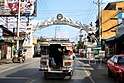 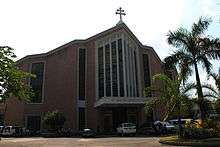  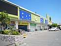 Clockwise from top-left: Dagupan City Welcome Arch, Metropolitan Cathedral of St. John The Evangelist, CSI Supermarket, Dagupan Train Museum | ||
| ||
| Nickname(s): Milk Fish Capital of the Philippines; The "Melting Pot" of Pangasinan and Region 1; Premier City of the North | ||
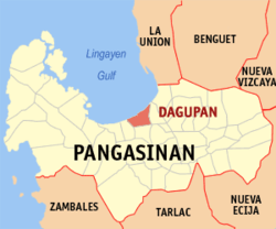 Map of Pangasinan with Dagupan highlighted | ||
.svg.png) Dagupan Location within the Philippines | ||
| Coordinates: 16°02′N 120°20′E / 16.03°N 120.33°ECoordinates: 16°02′N 120°20′E / 16.03°N 120.33°E | ||
| Country |
| |
| Region | Ilocos Region (Region I) | |
| Province | Pangasinan (geographically only) | |
| District | 4th district of Pangasinan | |
| Founded | 1590 | |
| Cityhood | June 20, 1947 | |
| Barangays | 31 (see Barangays) | |
| Government [1] | ||
| • Type | Sangguniang Panlungsod | |
| • Mayor | Belen T. Fernandez | |
| • Vice Mayor | Brian Lim | |
| • Electorate | 105,183 voters (2016) | |
| Area[2] | ||
| • Total | 44.47 km2 (17.17 sq mi) | |
| Population (2015 census)[3] | ||
| • Total | 171,271 | |
| • Density | 3,900/km2 (10,000/sq mi) | |
| Demonym(s) |
Dagupeño (masculine) Dagupeña (feminine) | |
| Time zone | UTC+8 (PST) | |
| ZIP code | 2400 | |
| PSGC | 015518000 | |
| IDD : area code | +63 (0)75 | |
| Climate type | Tropical monsoon climate | |
| Income class | 1st City Income Class[4] | |
| Revenue (₱) | 756,078,443.25 [5] | |
| Poverty incidence | 5.96 (2012)[6] | |
| Website |
dagupan | |

Dagupan, officially the City of Dagupan (Pangasinan: Siyudad na Dagupan, Filipino: Lungsod ng Dagupan), or simply Dagupan City, is a 1st Class Independent Component City[4] in the province of Pangasinan, Philippines. According to the 2015 census, it has a population of 171,271 people.[3]
Located on the Lingayen Gulf on the northwest-central part of the island of Luzon, Dagupan is a major commercial and financial center north of Manila. Also, the city is one of the centers of modern medical services, media and communication in North-Central Luzon. The city is situated within the fertile Agno River Valley.
The city is among the top producers of milkfish (locally known as bangus) in the province. From 2001-2003, Dagupan's milkfish production totaled to 35,560.1 metric tons (MT), contributing 16.8 percent to the total provincial production. Of its total production in the past three years, 78.5 percent grew in fish pens/cages while the rest grew in brackish water fishponds.[7]
Dagupan is administratively and politically independent from the provincial government of Pangasinan and is only represented by the province's legislative district.
Dagupan City is one of the proposed metropolitan area in the Philippines.[8] Metro Dagupan is proposed to include the independent component city of Dagupan, as well as the towns of Lingayen, Binmaley, Calasiao, Mangaldan, Manaoag, Mapandan, San Fabian, San Jacinto, and Santa Barbara.
Etymology
The city's name was derived from the local Pangasinan word pandaragupan, meaning "gathering place" as the city has been a regional market center for centuries.
History
Kaboloan
During the 15th century, Pangasinan had been the site of an ancient polity called the Kaboloan. the Wangdom of Pangasinan sent emissaries to China in 1406-1411.[9]
Spanish occupation
The area that is now known as Dagupan was described as marshland thickly covered with mangrove and nipa palm trees.[10] The natives lived along the shoreline and riverbanks of Calmay, Pantal, and Bonuan. But there were also communities in Malued, Lasip, Pogo, and Bacayao. The natives called the area Bacnotan which would later be incorporated into the encomienda of Lingayen that was established in 1583.
The first long distance railroad in the Philippines connecting Manila and Dagupan was opened on November 24, 1892.
Japanese Occupation
The Japanese planes bombed in Dagupan on December 1941; Dagupan was occupied by Japanese forces starting in 1942.[11]
Allied liberation
On January 8–January 9, 1945, U.S. General Douglas MacArthur landed his amphibious liberation force in the city's "Blue Beach" section along the Lingayen Gulf. From his beachhead in Dagupan, along with those in neighboring towns Lingayen, Binmaley and San Fabian, MacArthur's forces under General Walter Krueger together with the Philippine Commonwealth troops under the Philippine Army and Philippine Constabulary units were able to penetrate Japanese defenses in Luzon island and liberate Filipino and allied prisoners of war near Cabanatuan in the province of Nueva Ecija, and in Manila's University of Sto. Tomas, among others.
Dagupan's cityhood
Dagupan became a city by virtue of Republic Act No. 170, authored by Speaker Eugenio Pérez. It was signed into law by President Manuel Roxas on June 20, 1947.[12]
The westward expansion of the city went as far as Lucao, which was also swampland. Local historian Restituto Basa surmised that the name Lucao may have been derived from the shellfish called lukan that used to abound in the swampy area.
In June 1962, Dagupan was shaken by a series of strong earthquakes which occurred at irregular intervals for about three weeks. The quakes toppled the belfry of the Roman Catholic Church. Many people from Calmay, Carael and island barrios evacuated to other towns.
In 1968, the national government agencies opened offices in Dagupan and other key cities across the country. The daytime population increased substantially, causing congestion in the city that began to see the appearance of public utility tricycles.
On July 16, 1990, a magnitude 7.7 earthquake struck northern Luzon, causing liquefaction, which made buildings tilt and sink due to their heavy weight and the looseness of the ground, which turned into sediment-rich mud. The Magsaysay Bridge, one of the two bridges especially spanning the Pantal River, collapsed, delaying people from crossing to the other banks and vice versa. Major damage caused businesses to be permanently transferred to the neighbouring towns of Mangaldan and Calasiao, but somehow, Dagupan and its inhabitants managed to recover from the earthquake.[13]
Geography
Dagupan City covers a total land area of 4,447.10 hectares (10,989.0 acres), bounded by the Lingayen Gulf in the north, San Fabian in the northeast, Mangaldan in the east, Calasiao in the south and Binmaley in the west. Land use is primarily for agriculture with 35.98% of the total land area, fishpond, cropland, residential with 22.88%; others uses are commercial, industrial, institutional, government private, parks and roads.
Barangays
Dagupan City is politically subdivided into 31 barangays.[14]
|
|

Climate
| Climate data for Dagupan City (1981–2010, extremes 1903–2012) | |||||||||||||
|---|---|---|---|---|---|---|---|---|---|---|---|---|---|
| Month | Jan | Feb | Mar | Apr | May | Jun | Jul | Aug | Sep | Oct | Nov | Dec | Year |
| Record high °C (°F) | 36.0 (96.8) |
37.0 (98.6) |
38.7 (101.7) |
39.9 (103.8) |
39.6 (103.3) |
38.7 (101.7) |
38.2 (100.8) |
36.4 (97.5) |
36.6 (97.9) |
37.2 (99) |
36.9 (98.4) |
36.9 (98.4) |
39.9 (103.8) |
| Average high °C (°F) | 30.8 (87.4) |
31.8 (89.2) |
33.2 (91.8) |
34.7 (94.5) |
34.1 (93.4) |
33.1 (91.6) |
32.0 (89.6) |
31.3 (88.3) |
31.6 (88.9) |
31.9 (89.4) |
31.8 (89.2) |
30.9 (87.6) |
32.3 (90.1) |
| Daily mean °C (°F) | 25.8 (78.4) |
26.5 (79.7) |
27.9 (82.2) |
29.5 (85.1) |
29.4 (84.9) |
28.9 (84) |
28.2 (82.8) |
27.8 (82) |
27.9 (82.2) |
27.9 (82.2) |
27.4 (81.3) |
26.2 (79.2) |
27.8 (82) |
| Average low °C (°F) | 20.7 (69.3) |
21.2 (70.2) |
22.6 (72.7) |
24.4 (75.9) |
24.8 (76.6) |
24.7 (76.5) |
24.4 (75.9) |
24.3 (75.7) |
24.2 (75.6) |
24.0 (75.2) |
23.0 (73.4) |
21.4 (70.5) |
23.3 (73.9) |
| Record low °C (°F) | 14.3 (57.7) |
16.3 (61.3) |
16.7 (62.1) |
19.7 (67.5) |
19.0 (66.2) |
20.2 (68.4) |
20.4 (68.7) |
19.0 (66.2) |
20.5 (68.9) |
19.5 (67.1) |
17.2 (63) |
15.2 (59.4) |
14.3 (57.7) |
| Average rainfall mm (inches) | 6.7 (0.264) |
10.7 (0.421) |
22.2 (0.874) |
60.4 (2.378) |
209.8 (8.26) |
337.9 (13.303) |
499.6 (19.669) |
581.3 (22.886) |
368.4 (14.504) |
215.9 (8.5) |
53.9 (2.122) |
14.1 (0.555) |
2,380.9 (93.736) |
| Average rainy days (≥ 0.1 mm) | 1 | 1 | 2 | 5 | 12 | 17 | 21 | 22 | 20 | 11 | 5 | 2 | 119 |
| Average relative humidity (%) | 79 | 78 | 77 | 77 | 79 | 83 | 86 | 87 | 86 | 84 | 82 | 80 | 82 |
| Source: PAGASA[17][18] | |||||||||||||
Demographics
| Population census of Dagupan City | |||||||||||||||||||||||||||||||||||||||||||||||||
|---|---|---|---|---|---|---|---|---|---|---|---|---|---|---|---|---|---|---|---|---|---|---|---|---|---|---|---|---|---|---|---|---|---|---|---|---|---|---|---|---|---|---|---|---|---|---|---|---|---|
|
| ||||||||||||||||||||||||||||||||||||||||||||||||
| Source: Philippine Statistics Authority[3] [19] [20] [21] | |||||||||||||||||||||||||||||||||||||||||||||||||
In Dagupan, the Pangasinans are the predominant people and the Pangasinan language is predominantly used in the city and environs, followed by English and Filipino, as well as Ilocano. Chinese is mainly spoken only by a few city individuals of Chinese descent.
- Number of Registered Voters (2016): 105,183[14]
Transportation
Dagupan is connected with other cities by networks of national roads. Romulo Highway and Pangasinan - La Union Road (N55) and Urdaneta - Dagupan Road (N56) are the principal highways that serve the city.
The Philippine National Railways (PNR) once served Dagupan through Dagupan station, that went defunct in the late 1980s. The first railroad in the Philippines, the Manila-Dagupan Railway, terminated at the city.
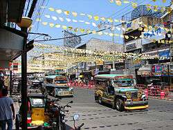
Intercity/interprovincial buses from Manila serve the city, and are usually operated by Dagupan Bus Company, Victory Liner, Five Star, and Pangasinan Solid North. Jeepneys provide intracity travel, as well as for towns and cities of close proximities.
Economy
_(Dagupan%2C_Pangasinan)(2018-02-25).jpg)
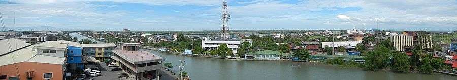
Dagupan is the economic center of Pangasinan and the rest of North-Central Luzon. As a hub, many people in Pangasinan commute to the city during the day. This causes the city's daytime population to rise and cause traffic to parts of the city, especially the downtown area. The city is a vital financial center housing numerous banks, non-bank financial institutions and offices of some of the government agencies.
Historically, Dagupan was a center for salt making in numerous salt evaporator beds in the low-lying swampy areas close to the Lingayen Gulf, Beginning in the 19th Century, some of the salt making operations gave way to pond culture of fish, most prominently the milkfish or as it is known locally ad bangus for which the city has become famous. Fisheries, aquaculture and processed fisheries products are an important mainstay of the city's economy.[22]
Another part of Dagupan's economy is the motor vehicle industry. Many automotive companies have a dealership in the city's metropolitan area. Existing car dealerships from major companies including Ford, Hyundai, Chevrolet, Mazda and Izuzu are all found in Dagupan, while other companies such as Toyota, Honda, Mitsubishi, Nissan and many more are found at the neighbouring town of Calasiao.
Education
Since the colonial era, Dagupan has always been the center of education in Ilocos Region (Region 1). The private sector-driven centers of education University of Pangasinan, University of Luzon and Lyceum-Northwestern University lead, 14 colleges and 18 vocational schools and 3 technical learning centers, 19 secondary schools and 53 elementary schools both in public and private.
Colleges and universities
Public secondary schools
|
Private primary and secondary schools
|
Health
Medical and health service centers abound in Dagupan. Out of 51 hospitals in Pangasinan, 12 are located in the city. The largest of these is the Region 1 Medical Center with hospital bed capacity of 600.
Media
Dagupan City is home to regional television stations of GMA Network, CNN Philippines, TV5 and ABS-CBN, sixteen radio broadcasting stations, at least seventeen local newspapers and three cable television companies. There are two news programs TV Patrol North Luzon (ABS-CBN TV-32 Dagupan) and Balitang Amianan (GMA Dagupan).
Sister cities


References
- ↑ "City". Quezon City, Philippines: Department of the Interior and Local Government. Retrieved 30 May 2013.
- ↑ https://www.dagupan.gov.ph
- 1 2 3 Census of Population (2015). "Region I (Ilocos Region)". Total Population by Province, City, Municipality and Barangay. PSA. Retrieved 20 June 2016.
- 1 2 http://pangasinan.gov.ph/the-province/cities-and-municipalities/dagupan-city/
- ↑ "Pangasinan : Cities and Municipalities Competitiveness Index". Makati City, Philippines: National Competitiveness Council (Philippines). Archived from the original on 28 January 2017. Retrieved 28 January 2017.
- ↑ "PSA Releases the 2012 Municipal and City Level Poverty Estimates". Quezon City, Philippines: Philippine Statistics Authority. Archived from the original on 28 January 2017. Retrieved 28 January 2017.
- ↑ "Dagupan City: The Home of the World’s Longest Barbecue". National Statistical Coordination Board Profile. Retrieved on 2012-05-30.
- ↑ Dagupan Metropolitan Area or Metro Dagupan (DMA) is a metropolitan area in north central Luzon http://wowdagupantoday.blogspot.com/2011/01/new-metropolis-rising-in-pangasinan.html
- ↑ Scott, William Henry (1989). "Filipinos in China in 1500" (PDF). China Studies Program. De la Salle University. p. 8.
- ↑ "Dagupan City in Pangasinan Luzon PhilippinesPhilippines". www.philippine-islands.ph. Archived from the original on 2015-12-08. Retrieved 2015-11-27.
- ↑ "Reporter Predicted Japanese Attack - Pearl Harbor - Hector C. Bywater". www.lindseywilliams.org. Retrieved 2015-11-27.
- ↑ "Republic Act No. 170 - An Act Creating the City of Dagupan". Chan Robles Virtual Law Library. Retrieved 31 January 2016.
- ↑ Gabriel Cardinoza (July 24, 2012). "Dagupan Rises From 1990 Nightmare". The Philippine Daily Inquirer.
- 1 2 "Municipality/City: Dagupan City" Archived 2012-05-10 at the Wayback Machine.. PSGC Interactive. Retrieved on 2012-05-29.
- 1 2 "Total Population by Province, City, Municipality and Barangay: as of May 1, 2010" (PDF). 2010 Census of Population and Housing. Philippine Statistics Authority. Archived from the original (PDF) on 15 November 2012. Retrieved 5 September 2013.
- ↑ "Total Population by Province, City, Municipality and Barangay: as of August 1, 2007: Pangasinan". Philippine Statistics Authority. Philippine Statistics Authority. April 2008. Archived from the original (PDF) on 20 November 2008. Retrieved 14 October 2014.
- ↑ "Dagupan City, Pangasinan Climatological Normal Values". Philippine Atmospheric, Geophysical and Astronomical Services Administration. Archived from the original on 11 October 2018. Retrieved 11 October 2018.
- ↑ "Dagupan City, Pangasinan Climatological Extremes". Philippine Atmospheric, Geophysical and Astronomical Services Administration. Archived from the original on 11 October 2018. Retrieved 11 October 2018.
- ↑ Census of Population and Housing (2010). "Region I (Ilocos Region)". Total Population by Province, City, Municipality and Barangay. NSO. Retrieved 29 June 2016.
- ↑ Censuses of Population (1903–2007). "Region I (Ilocos Region)". Table 1. Population Enumerated in Various Censuses by Province/Highly Urbanized City: 1903 to 2007. NSO.
- ↑ "Province of Pangasinan". Municipality Population Data. Local Water Utilities Administration Research Division. Retrieved 17 December 2016.
- ↑ "Aquaculture in Dagupan City, Philippines". World Aquaculture 29(1):18-24. March 1998. Retrieved 3 Jul 2018.
- ↑ "Sister Cities, Public Relations". Guadalajara municipal government. Archived from the original on March 2, 2012. Retrieved March 12, 2013.
- ↑ "30th year of Dagupan-Iwata sisterhood pact celebrated". Sunday Punch Line. Retrieved December 4, 2013.
- ↑ "Dagupan, Milpitas renew sisterhood pact – Sunday Punch". punch.dagupan.com. Retrieved 2016-07-04.
- ↑ www.taoti.com, Taoti Creative, Washington DC / May 2012 /. "Interactive City Directory". www.sister-cities.org. Retrieved 2016-07-04.
Further reading
- Basa, Restituto (1972). Story of Dagupan. Manaois Press.
External links
| Wikivoyage has a travel guide for Dagupan. |
| Wikimedia Commons has media related to Dagupan. |
- Official website
- Dagupan Tourism
- City Profile at the National Competitiveness Council of the Philippines
- Dagupan at the Pangasinan Government Website
- Local Governance Performance Management System
- Philippine Standard Geographic Code
- Philippine Census Information
Places adjacent to Dagupan | ||||||||||
|---|---|---|---|---|---|---|---|---|---|---|
| ||||||||||
