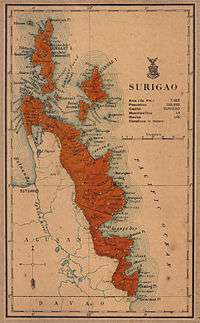
Dinagat Islands
| Dinagat Islands | |||
|---|---|---|---|
| Province | |||
| Province of Dinagat Islands[1] | |||
 Beach near Pangabangan, Dinagat Islands | |||
| |||
 Location in the Philippines | |||
| Coordinates: 10°06′N 125°36′E / 10.1°N 125.6°ECoordinates: 10°06′N 125°36′E / 10.1°N 125.6°E | |||
| Country | Philippines | ||
| Region | Caraga (Region XIII) | ||
| Founded | 2 December 2006 | ||
| Capital | San Jose | ||
| Government | |||
| • Type | Sangguniang Panlalawigan | ||
| • Governor | Glenda Ecleo (UNA) | ||
| • Vice Governor | Benglen Ecleo (UNA) | ||
| • Representative | Kaka Bag-ao (Liberal) | ||
| Area[2] | |||
| • Total | 1,036.34 km2 (400.13 sq mi) | ||
| Area rank | 75th out of 81 | ||
| Highest elevation (Mount Redondo) | 939 m (3,081 ft) | ||
| Population (2015 census)[3] | |||
| • Total | 127,152 | ||
| • Rank | 77th out of 81 | ||
| • Density | 120/km2 (320/sq mi) | ||
| • Density rank | 65th out of 81 | ||
| Divisions | |||
| • Independent cities | 0 | ||
| • Component cities | 0 | ||
| • Municipalities | |||
| • Barangays | 100 | ||
| • Districts | Lone district of the Dinagat Islands | ||
| Time zone | UTC+8 (PHT) | ||
| ZIP code | 8411–8415, 8426, 8427 | ||
| IDD : area code | +63 (0)86 | ||
| ISO 3166 code | PH | ||
| Spoken languages | |||
| Income classification | 4th class | ||
| Website |
dinagatislands | ||


The Dinagat Islands are a group of islands constituting a province in the Caraga region in the Philippines, located on the south side of Leyte Gulf. The island of Leyte is to its west, across Surigao Strait, and Mindanao is to its south. Its main island, Dinagat, is about 60 kilometres (37 mi) from north to south. Declared a province in 2006, the Dinagat Islands comprise the second newest province of the Philippines, with Davao Occidental (2013) being the newest.
History
The province is known as one of the archipelago's holiest sites in the Pre-Christian native religion. It is here where the God of Hurricanes was persuaded to relent his attacks on the islands by Da, the God of Peace. The province in pre-colonial times was much influenced by the Rajahnate of Butuan which was nestled in present-day Agusan del Norte. It was also used as the entry point of the Rahajnate of Ternate, present-day Moluccas of Indonesia, to attack the Rajahnate of Butuan, Rajahnate of Cebu, the indigenous settlements in the Anda Peninsula of Bohol, and the Kingdom of Dapitan (located 'between Panglao and Bohol), which later moved in northern Zamboanga after the Kingdom of Dapitan was destroyed.
Although one of the newest provinces of the country, settlements in the Dinagat Islands were already present during the Spanish regime as a result of migration of people from nearby provinces of Bohol and Leyte. The so-called mystical province played an important role in the country's history, particularly during World War II. Adding to the historical significance of the province is the foundation of the Philippine Benevolent Missionaries Association by Ruben Ecleo, Sr.
The municipality of Dinagat is the oldest community in the province. In the early days, a story was told that a stranger reached the place in search of greener pastures. He approached a native and asked what the inhabitants do for a living. The natives said that they farm and fish to live. The stranger's interest in fishing prompted him to inquire where they fish, and the native replied and pointed to a place saying dinhi niini na dagat (here from this bountiful waters). Since then, the place was called "Dinagat".
The municipality was formally established in 1855. It occupies the territorial boundaries of the whole island. From 1890 to 1990 its boundaries were gradually reduced giving rise to six municipalities, Loreto, Cagdianao, Libjo, Basilisa, Tubajon and San Jose.

Loreto became a Spanish pueblo on September 4, 1890 under the supervision of Governor General Manuel Sanchez by the virtue of Direccion General No. 30. It was originally called Mabua due to the ever-foaming river that runs right into the center of the community. It was named Loreto in 1881 by the Spanish priest who frequents the town, in honor of the wife of the Alcalde Mayor of the Province of Surigao.
The province was the site of the historic Battle of Surigao Strait during the Second World War. The Municipality of Loreto became the entry point of the American Liberation Forces on October 17, 1944. It was on this shore that the 6th Ranger Battalion of the 6th U.S. Army under Col. Mucci landed at Sitio Campinta of Barangay Panamaon in Loreto. It was during this landing that the first American flag flew on Philippine soil since the Japanese invasion in 1941. The Americans named the place "Black Beach No. 2."
The northern part of the island served as a refuge for the American soldiers, while the western border was held by Japanese forces. Capsized vessel structures are still found today in the waters of Basilisa.
On December 23, 1959, Cagdianao was created into a municipality under Executive Order No. 367.[4] Its name came from the Spanish word Cada dia linao meaning "everyday peaceful and calm". However some scholars say that its name came from the Visayan word Taga Danaw meaning "the lake people".
Libjo was created into a municipality and named Albor on February 29, 1960 under Executive Order No. 381.[5] It was taken from the municipalities of Dinagat and Loreto. Albor came from the surname of the mayors of Loreto and Dinagat — Alfaro and Borja. It was renamed as Libjo on June 17, 1967. The name came from the word Liboo, a kind of mussel clam.
In 1965, Ruben Edera Ecleo Sr. founded the Philippine Benevolent Missionaries Association (PBMA) at Sitio Puyange, now Poblacion in San Jose. PBMA is a non-sectarian organization bounded by a strong spirit of brotherhood. Not long after that, members from all over the Philippines migrated to the island to be in constant association with their founder.
Meanwhile, Basilisa became a municipality on June 17, 1967 under Republic Act No. 4986. It was then named as Rizal, after the country's national hero.[6] The municipality was renamed as Basilisa on June 21, 1969 under Republic Act. No. 5775.[7]
Tubajon, which was once a barangay of Loreto, became a municipality on June 21, 1969 under Republic Act No. 5643. According to local folklore, during the Spanish regime, a banca boarded with Guardia Civils landed in the shores of Tubajon in search of a criminal. One of them came across a river and saw a man pounding leaves. Curious, he asked the man, "What will you do with it?" The man answered "Akong Tubajon ang suba aron sayon dakpon ang mga isda" (I will poison the river with Tuba leaves so that the fishes could be easily caught). When the man returned to the group, he narrated everything he saw and heard from the native to his companions. From then on, the place was called Tubajon.
The newest municipality is San Jose, created on November 15, 1989, under Republic Act No. 6769.[8] The town was named in honor of Jose Ecleo who was its pioneer and father of then mayor of the municipality of Dinagat, Ruben Edera Ecleo Sr. The town is the seat of the PBMA.
The Dinagat Islands was part of the First District of Surigao del Norte Province until it became a province on December 2, 2006, with the approval of Republic Act No. 9355 (authored by Rep. Glenda B. Ecleo), the Charter of the Province of the Dinagat Islands, in a plebiscite.[1] President Gloria Macapagal-Arroyo appointed the province's first set of officials on January 26, 2007.[9] Provincial officials were first elected a few months later, in the May 14, 2007 elections; these elected officials took office on July 1, 2007.[9]
On February 11, 2010, the Supreme Court of the Philippines declared the creation of the Dinagat Islands Province null and void on grounds of failure to meet land area and population requirements for the creation of local government units.[10][11][12] The decision was not yet rendered final and executory before the May 10, 2010 elections; therefore the Commission on Elections still organized the elections for the province's separate congressional representative and provincial officials.[13] Although the original decision was made final and executory on May 18, 2010—thereby reverting the Dinagat Islands to Surigao del Norte—the officials elected in 2010 continued to serve the province, even throughout the legal battles that followed, which eventually saw the Supreme Court reverse its position.[9]
On April 12, 2011 the Supreme Court reversed its earlier ruling,[14] upholding the constitutionality of Republic Act No. 9355 and validating the creation of Dinagat Islands as a province. An Entry of Judgment on October 24, 2012 ended the legal battles surrounding the status of the province, and finalized the separation of Dinagat Islands from Surigao del Norte.[15]
Geography


Located to the northeast of Surigao del Norte, the Dinagat Islands are separated physically from the mainland of Surigao City by a narrow channel, which takes about 45 minutes to cross by pumpboat from the Surigao City Port to San Jose Port. The province is one of the smallest island provinces in the country with a total land area of 1,036.34 square kilometres (400.13 sq mi).[16]
The province consists of the eponymous Dinagat Island and surrounding islands and islets, including Cabilan Island in Dinagat, La Isla Aga and Lalaking Bukid in Basilisa, Kisses Islets in Libjo, and Hibuson, Stingray Islet, and Puyo Islet in Loreto. Mount Redondo is Dinagat highest point standing at 939 metres (3,081 ft) above sea level.
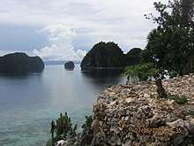
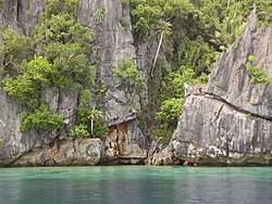
The Dinagat Islands are known for its caves, resorts, and beaches. These include Bitaug Beach, Campintac Black Beach No. 2, Linao Spring Resort, and San Juan Cave (all in Loreto), Lake Bababu, Puerto Prinsesa Beach & Hagakhak Cave in Basilisa, Tagberayan Beach, Sayaw Beach, Legaspi Water Falls, Hinabyan and Leandro's Beach Resort in Cagdianao, Talisay Beach in Tubajon, Quano Blue Lagoon and Quano Cave, Ben Paz Mountain Resort and Oasis Islet Resort in Libjo, and the Cab-ilan Beach & Cab-ilan Gamay Beach in Dinagat.
Administrative divisions
The Dinagat Islands province comprises seven (7) municipalities, all encompassed by a single legislative district.
| Municipality [lower-roman 1] | Population | ±% p.a. | Area[16] | Density | Brgy. | |||||||
|---|---|---|---|---|---|---|---|---|---|---|---|---|
| (2015)[3] | (2010)[17] | km2 | sq mi | /km2 | /sq mi | |||||||
| 9°59′55″N 125°30′37″E / 9.9985°N 125.5104°E | Basilisa | 29.0% | 36,880 | 33,880 | +1.63% | 92.68 | 35.78 | 400 | 1,000 | 27 | ||
| 9°55′22″N 125°40′19″E / 9.9229°N 125.6719°E | Cagdianao | 13.2% | 16,808 | 15,047 | +2.13% | 249.48 | 96.32 | 67 | 170 | 14 | ||
| 9°57′39″N 125°35′28″E / 9.9609°N 125.5911°E | Dinagat | 8.4% | 10,632 | 12,786 | −3.45% | 139.94 | 54.03 | 76 | 200 | 12 | ||
| 10°11′43″N 125°31′57″E / 10.1953°N 125.5325°E | Libjo | 14.0% | 17,760 | 17,567 | +0.21% | 180.57 | 69.72 | 98 | 250 | 16 | ||
| 10°21′33″N 125°34′45″E / 10.3592°N 125.5793°E | Loreto | 7.3% | 9,309 | 8,920 | +0.82% | 255.87 | 98.79 | 36 | 93 | 10 | ||
| 10°00′34″N 125°34′15″E / 10.0095°N 125.5708°E | San Jose | † | 21.6% | 27,487 | 31,035 | −2.29% | 27.80 | 10.73 | 990 | 2,600 | 12 | |
| 10°19′38″N 125°33′22″E / 10.3272°N 125.5562°E | Tubajon | 6.5% | 8,276 | 7,568 | +1.72% | 90.00 | 34.75 | 92 | 240 | 9 | ||
| Total | 127,152 | 126,803 | +0.05% | 1,036.34 | 400.13 | 120 | 310 | 100 | ||||
| † Provincial capital | Municipality | |||||||||||
| ||||||||||||
Demographics
| Population census of the Dinagat Islands | ||
|---|---|---|
| Year | Pop. | ±% p.a. |
| 1990 | 98,865 | — |
| 1995 | 100,537 | +0.31% |
| 2000 | 106,951 | +1.33% |
| 2007 | 120,813 | +1.70% |
| 2010 | 126,803 | +1.78% |
| 2015 | 127,152 | +0.05% |
| Source: Philippine Statistics Authority[3] [17] [18] | ||
The population of the Dinagat Islands in the 2015 census was 127,152 people,[3] with a density of 120 inhabitants per square kilometre or 310 inhabitants per square mile.
Old settlers of the province are called "Lumad". Residents of the Dinagat Islands are called "Dinagatnon". The Dinagat Islands is predominantly a Cebuano-speaking province. However, towns facing the Surigao del Norte are Surigaonon-speaking, particularly the municipalities of Dinagat and Cagdianao due to their proximity to the province of Surigao del Norte. Influences of the Cebuano and Boholano languages with a Tausug accent can be traced. A majority speak English.
Religion
Religious breakdown in the province shows Roman Catholicism at majority with 53% adherence while Aglipayan is the significant minority religion at 23%. Other minority religions are the Seventh-day Adventists (12%), United Church of Christ in the Philippines (4%), Iglesia Ni Cristo (3%) and other smaller Christian groups (Dinagat Island Socio Economic Factbook, 2007).
Recent cultural, religious and socioeconomic changes of the province have allowed the rebound of Roman Catholics (and Aglipayans in some degree) and their numbers have constantly increased; the province had experienced a Catholic decline in several decades (1970s-early 2000s) due to immigration of the members of Philippine Benevolent Missionaries Association in the 1960s. There were some decades (1990s-2000s) where Roman Catholics became minority with as low as 37% of the population.
Several religious conflicts were recorded in the province. But at present, religious harmony is relatively observed in most parts of Dinagat Island.
Culture
The Dinagat Islands have unique structures and landmarks as reminders of an affluent way of life.

Some of which are:
- Galeto Ancestral Home, Tubajon
- Cuarenta Pulang Lupa and Islander's Castle, San Jose
- Biray-Biray Rock Formation and Lalaking Bukid, Basilisa
- Tubajon Bat Sanctuary[19] and Babaeng Bukid (Female Mountain), Tubajon
- Campintac Landmark and Kisses Islet of Libjo, Loreto
Festivals

- Bugkusan sa Isla ... Dinagatan Festival — a provincial festival bringing together Dinagat Island's seven municipalities. The festival celebrates the islands rich history, arts & culture, tourism, trade, commerce & industry, beauty & talent.[20]
- Banwag Festival — San Jose
- Sirong-Sirong Festival — Cagdianao
- Kinabog Festival — Tubajon
- Lawigan Festival — Loreto
Tourism & Attractions
Dinagat Islands is a young island-province at the northern tip of Mindanao. Many describe Dinagat Islands as a hidden gem of the Caraga Region XIII. The Islands are enriched with great bio-diversity, abundant natural wonders and rich resources. Dinagat Islands has a multitude of fascinating white sandy beaches with arrays of colossal rock formations. These sites and attractions are as diverse as the topography of the islands and islets.
According to an old legend told by older islanders, who called themselves Lumads of the island-province, there is a story behind the naming of the island to "DINAGAT". There once was a "Prinsesa" named Dina and "Prinsipe" named Gat who escaped from their respective kingdom. They nourished, cultivated and protected the island-paradise in preparation for the future generations. One day, the island-paradise was invaded by foreign intruders. The couple and their children escaped from their enemies.
They dove and swam in the deep blue sea and until today their survival is still a mystery because after two days, two mythical islets appeared in the middle of the sea replicating a giant human figure that the Lumads called "Lalaki and Babaeng Bukid. "Lalaking Bukid and "Babaeng Bukid" is "Prinsesa Dina" when combined becomes Dina-Gat or Dinagat.[21]
Provincial Tourism & Culture Office, (PTCO)
Dinagat Islands has 7 Municipal Provincial Tourism & Culture Offices, (PTCO) located in each municipality. The main office is located in the Brgy. San Juan, San Jose.[22]
Provincial Tourism & Culture Office, Email: ptco.dinagatislands@gmail.com Phone: (+63) 9483958853 ; (+63) 9773002415 ; (+63) 9506682780
List of Attractions
Below is a list of Beach Resorts & tourists attractions, recognized by the "Provincial Tourism & Culture Office, (PTCO)". Listed by Island and Municipality, from north to south and east to east.
Loreto Municipality
| Image | Name | Location | Island/City | Municipality | Type of Attraction | Notes | |
|---|---|---|---|---|---|---|---|
| Black Beach No. 2/US Landing Marker | (Mainland) | Loreto | Historical Site | Historic WWII Site | |||
| Linao Spring Resort | (Mainland) | Loreto | Natural Spring Resort | ||||
| Polo Islet | (Mainland) | Loreto | Islet | ||||
| Kamangon Cave | (Mainland) | Loreto | Cave | ||||
| Hinophopan Cave | (Mainland) | Loreto | Cave | ||||
| Mini Hydro Electric Plant | (Mainland) | Loreto | Hydro Electricity Plant | ||||
| Mount Redondo/Bonsai Forest | (Mainland) | Loreto | Bonsai Forest | ||||
| Cambinliw Watershed | (Mainland) | Loreto | Watershed | ||||
| Sangay Beach | (Mainland) | Loreto | Beach Resort | ||||
| Dhican Beach 1 | 10.454710, 125.486207 | Hibusong Island | Loreto | Beach Resort | |||
| Dhican Beach 2 | Hibusong Island | Loreto | Beach Resort | ||||
| Liberty Beach | Hibusong Island | Loreto | Beach Resort |
Tubajon Municipality
| Image | Name | Location | Island/City | Municipality | Type of Attraction | Notes | |
|---|---|---|---|---|---|---|---|
| SPDC (Sinapyahan Beach) | (Mainland) | Tubajon | Beach Resort | ||||
| Galeto Ancestral House | (Mainland) | Tubajon | Historical Building | ||||
| Talisay Beach | (Mainland) | Tubajon | Beach Resort | ||||
| Bankaw Falls | (Mainland) | Tubajon | Waterfall | ||||
| Tambongon Lagoon | (Mainland) | Tubajon | Lagoon | ||||
| Tubajon Bat Sanctuary | (Mainland) | Tubajon | Bat Sanctuary | ||||
| 7 Tier Waterfalls | (Mainland) | Tubajon | Waterfall | ||||
| Paragamac Beach | (Mainland) | Tubajon | Beach Resort |
Libjo Municipality
| Image | Name | Location | Island/City | Municipality | Type of Attraction | Notes | |
|---|---|---|---|---|---|---|---|
| Mount Palhi Babaeng Bukid | (Mainland) | Libjo | Bukid | (Bukid) means small hill or mountain. | |||
| Kisses Islet | (Mainland) | Libjo | Islet | ||||
| Salvador Beach | (Mainland) | Libjo | Beach Resort | ||||
| Beloved Beach Resort | (Mainland) | Libjo | Beach Resort | ||||
| Pangabangan Beach | (Mainland) | Libjo | Beach Resort | ||||
| Blue Lagoon Tidal Pool | (Mainland) | Libjo | Tidal Pool | ||||
| Jelmar's Islet Resort[23] | 10.173102, 125.500087 | Magsaysay | Libjo | Beach Resort | |||
| Quano Cave | (Mainland) | Libjo | Cave | ||||
| Punta Villa Cave | (Mainland) | Libjo | Cave | ||||
| Oasis Islet | (Mainland) | Libjo | Islet | ||||
| Punta Villa Beach[24] | (Mainland) | Libjo | Beach Resort | ||||
| Punta Buena Suarte Resort[25] | (Mainland) | Libjo | Beach Resort |
Basilisa Municipality
| Image | Name | Location | Island/City | Municipality | Type of Attraction | Notes | |
|---|---|---|---|---|---|---|---|
| Bitaog Beach | 10.010314, 125.526781 | Unib Island | Basilisa | Beach Resort | |||
| Cabacongan Beach | Unib Island | Basilisa | Beach Resort | ||||
| Duyos Camping Resort | Unib Island | Basilisa | Cottage Resort | Popular resort among locals, white sandy beaches, abundant Starfish and rock formations. | |||
| Gealan Beach | Unib Island | Basilisa | Beach Resort | ||||
| Isla Aga | (Mainland) | Basilisa | |||||
| Catadma Beach | Lingig Island | Basilisa | Beach Resort | ||||
| Sondayo Beach[26] | 10.083307, 125.482142 | Hagakhak Island | Basilisa | Beach Resort | |||
| Agongon Cove | (Mainland) | Basilisa | Cove | ||||
| Bababu Beach | 10.069292, 125.506937 | (Mainland) | Basilisa | Beach Resort | This is the starting point of the Bababu Lake hiking trail. | ||
| Bababu Lake[27] | 10.074326, 125.509112 | (Mainland) | Basilisa | Lake | Bababu Lake is the largest of four marine lakes in Basilisa and is a unique body of water. Although composed mostly of seawater, it has a 20-foot top layer of rainwater. These two layers of water do not mix because the lake is protected from the wind by towering chalk-white limestone walls draped in riotous foliage. The name of the lake was derived from the Cebuano words baba sa buwaya or crocodile’s mouth, referring to the shape of Babas Cove, the inlet that funnels to a small white-sand beach where the lake trail begins. | ||
| Bilabid Beach | (Mainland) | Basilisa | Beach Resort | ||||
| Baclayan Beach[28] | 10.067163, 125.577949 | (Mainland) | Basilisa | Beach Resort | |||
| Forest Park Inn | (Mainland) | Basilisa | Inn | ||||
| Palahang Resort | (Mainland) | Basilisa | Beach Resort |
San Jose Municipality
| Image | Name | Location | Island/City | Municipality | Type of Attraction | Notes | |
|---|---|---|---|---|---|---|---|
| Lawis Beach | (Mainland) | San Jose | Beach Resort | ||||
| Santa Cruz Beach[29] | 10.025109, 125.575367 | (Mainland) | San Jose | Beach Resort | |||
| San Jose Watershed | (Mainland) | San Jose | Watershed | ||||
| 3R Swimming Pool | (Mainland) | San Jose | Swimming pool | ||||
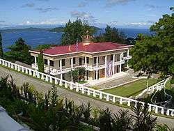
| Philippine Benevolent Missionaries Association Administration Building | San Jose | San Jose | Community gathering place | Many festivals are held here, including the PBMA Banwag Festival and Bugkosan Festival. | |||
| Divine Master's Shrine | 10.004665, 125.580598 | San Jose | San Jose | Shrine | ||
| San Jose Public Market | 10.009095, 125.568740 | (Mainland) | San Jose | Market | |||
| Islander's Castle[30] | 10.002225, 125.584302 | San Jose | San Jose | Tourist attraction |
Dinagat Municipality
| Image | Name | Location | Island/City | Municipality | Type of Attraction | Notes | |
|---|---|---|---|---|---|---|---|
| Baeng Beach | (Mainland) | San Jose | Beach Resort | ||||
| Khass Tasil Farm Resort | (Mainland) | San Jose | Resort | ||||
| Stingrays Inlet | (Mainland) | San Jose | Inlet | ||||
| Asinan LCD Seminar House | (Mainland) | Dinagat | |||||
| Catadaman Beach | (Mainland) | Dinagat | Beach Resort | ||||
| Divine Master White House | (Mainland) | Dinagat | Historical building | ||||
| Bijasong Beach | (Mainland) | Dinagat | Beach Resort | ||||
| Leonora Edera Resort | (Mainland) | Dinagat | Resort | ||||
| Biasong Beach | Cabilan Islands | Dinagat | Beach Resort | ||||
| Cabilan Rock Formation/Dive Site | Cabilan Islands | Dinagat | Recreational diving | ||||
 | Divine Master's Monument | Cabilan Islands | Dinagat | Historic Monument | |||
| Edera Beach | Cabilan Islands | Dinagat | Beach Resort | ||||
| Islanders Beach | Cabilan Islands | Dinagat | Beach Resort |
Cagdianao Municipality
| Image | Name | Location | Island/City | Municipality | Type of Attraction | Notes | |
|---|---|---|---|---|---|---|---|
| Legaspi Falls | (Mainland) | Cagdianao | Waterfall | ||||
| Punong | (Mainland) | Cagdianao | |||||
| Tidal Pool | (Mainland) | Cagdianao | Tidal Pool | ||||
| Mayatoy Rock & Roll Falls | (Mainland) | Cagdianao | Waterfall | ||||
| Hinabyan Beach | (Mainland) | Cagdianao | Beach Resort | ||||
| Del Pilar Dam | (Mainland) | Cagdianao | |||||
| Immaculate Conception Church | (Mainland) | Cagdianao | Historical building | ||||
| Campijagit Point | (Mainland) | Cagdianao | Surfing area | ||||
| Tagbirayan Beach Resort | (Mainland) | Cagdianao | Beach Resort | ||||
| Dakit-dakita Dive Site | (Mainland) | Cagdianao | Scuba diving site | ||||
| Leandro's Beach Resort | (Mainland) | Cagdianao | Beach Resort | ||||
| Sogbohan Islet | (Mainland) | Cagdianao | Islet | ||||
| The Strand Pension House & Resort | (Mainland) | Cagdianao | Resort | ||||
| Campagoyok Mangrove | (Mainland) | Cagdianao | Mangrove | ||||
| Sayaw Islet | (Mainland) | Cagdianao | Islet | ||||
| Daku Waterfalls | (Mainland) | Cagdianao | Waterfall |
Gallery
Geography
.jpg) Magsaysay, Dinagat Islands. |
.jpg) Magsaysay, Dinagat Islands. |
.jpg) Magsaysay, Dinagat Islands. |
.jpg) Magsaysay, Dinagat Islands. |
.jpg) Magsaysay, Dinagat Islands. |
.jpg) Magsaysay, Dinagat Islands. |
.jpg) Magsaysay, Dinagat Islands. |
.jpg) Magsaysay, Dinagat Islands. |
.jpg) Magsaysay, Dinagat Islands. |
Magsaysay, Dinagat Islands. |
 Magsaysay, Dinagat Islands. |
 Pangabangan, Dinagat Islands. |
.jpg) Pangabangan, Dinagat Islands. |
.jpg) Libjo, Dinagat Islands |

.jpg) Libjo, Dinagat Islands |
 Libjo, Dinagat Islands. |
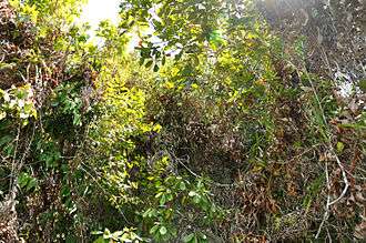
 Nepenthes Viridis Islet, Dinagat Islands. |
.jpg) Traditional Filipino houses, Dinagat Islands. |
 Farmhouse, San Jose, Dinagat Islands |
 Coconut farm, Dinagat Island. |
.jpg) Preparing coconuts for coconut oil. |
.jpg) Coconut farm, Dinagat Island. |
 Coconut farm, Dinagat Island. |
Government
The Governor of the Dinagat Islands is the local chief executive of the province of the Dinagat Islands.
| No. | Name | Took office | Left office | Party | |
|---|---|---|---|---|---|
| 1 | Geraldine B. Ecleo-Villaroman | 2007 | 2010 | ||
| 3 | Glenda B. Ecleo | 2010 | 2013 | Lakas-Kampi | |
| 2013 | 2016 | Nacionalista | |||
| 2016 | present | UNA | |||
Environment and wildlife
The Dinagat Islands is one of the most environmentally-significant provinces in the Philippines, where endemism of fauna is unique in its region. Animals that are endemic to the province include the critically endangered Dinagat bushy-tailed cloud rat which was recently rediscovered after decades of disappearance, the endangered Dinagat hairy-tailed rat, Dinagat Gymnure which has been declared by the EDGE Species Programme of the Zoological Society of London as one of the top 100 most evolutionary distinct and globally endangered species in the world, and a strange sub-species of the Philippine Tarsier which is unusually larger and darker in color than the common Philippine tarsier. The province is highly forested and is considered as a Key Biodiversity Area by Haribon Foundation and the Department of Environment and Natural Resources of the Philippines because of its unique fauna and flora, along with its lush rainforest which are classified as primary forests, or forests which have never been fully obliterated since pre-colonial times.
UNESCO has once recommended the filing of UNESCO World Heritage Site nomination for areas in the country with high endemism rate and high conservation rate, such as the Dinagat Islands. The UNESCO nomination bid of Mount Hamiguitan Range Wildlife Sanctuary of Davao Oriental was approved last 2014 after the government filed a nomination for it after the UNESCO recommendation.
Gallery
Plants
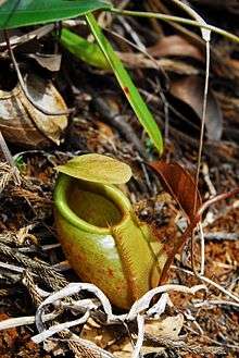
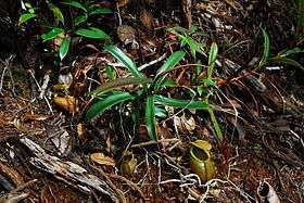
Nepenthes Viridis
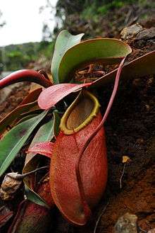
 Nepenthes viridis intermediate pitcher, photographed on an islet off Dinagat Island. |
 Nepenthes viridis upper pitcher, photographed on an islet off Dinagat. |
 Nepenthes viridis habitat, photographed on an islet off Dinagat, Philippines. |
Nepenthes Merrilian
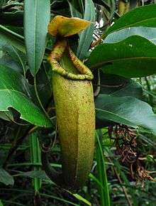 Nepenthes merrilliana upper pitcher from Dinagat Islands. |
 Nepenthes merrilliana lower pitcher from Dinagat Island. |
 Nepenthes merrilliana lower pitcher from Dinagat Islands. |
 Nepenthes merrilliana young plant from Dinagat Islands. |
Nepenthes Mindanaoensis
 Nepenthes mindanaoensis upper pitcher from Dinagat Islands. |
 Nepenthes mindanaoensis upper pitcher from Dinagat Islands. |
Nepenthes Bellii
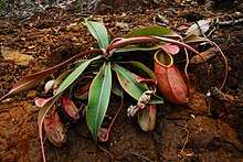
 Nepenthes bellii lower pitcher from Dinagat Island. |
 Nepenthes bellii rosette plant, Dinagat Islands. |
Animals
 Giant scops owl Otus gurneyi (Tweeddale, 1879) (= Mimizuku gurneyi). |
 Carlito syrichta (Philippine Tarsier), found on Dinagat Island. |
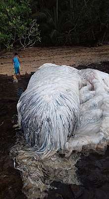 Trunko carcass washed ashore, near Cagdianao, Dinagat Islands. |
 Trunko carcass washed ashore, near Cagdianao, Dinagat Islands. |
_(8275373870).jpg) Jewel Beetle, Dinagat Islands. |
.jpg) Familie: Cerambycidae Größe: 18 mm Fundort: Philippinen, Dinagat-Isl. det. Breuning; Holotypus, Coll. Museum Dresden Foto: U.Schmidt, 2008 |
References
- 1 2 "Republic Act No. 9355. An Act Creating the Province of Dinagat Islands" (PDF). Senate of the Philippines. Retrieved 19 December 2015.
- ↑ "List of Provinces". PSGC Interactive. Makati City, Philippines: National Statistical Coordination Board. Archived from the original on 21 January 2013. Retrieved 27 March 2013.
- 1 2 3 4 Census of Population (2015). Highlights of the Philippine Population 2015 Census of Population. PSA. Retrieved 20 June 2016.
- ↑ "Executive Order No. 367; Creating the Municipality of Cagdianao in the Province of Surigao". Official Gazette of the Republic of the Philippines. Retrieved 19 December 2015.
- ↑ "Executive Order No. 381; Creating the Municipality of Albor in the Province of Surigao". Official Gazette of the Republic of the Philippines. Retrieved 19 December 2015.
- ↑ "Republic Act No. 4986 - An Act Creating the Municipality of Rizal in the Province of Surigao del Norte". Chan Robles Virtual Law Library. Retrieved 19 December 2015.
- ↑ "Republic Act No. 5775 - An Act Creating the Municipality of Basilisa in the Province of Surigao del Norte". Chan Robles Virtual Law Library. Retrieved 19 December 2015.
- ↑ "Republic Act No. 6769; An Act Creating the Municipality of San Jose in the Province of Surigao del Norte". The LawPhil Project. Retrieved 19 December 2015.
- 1 2 3 Famacion, Lilibeth A. (March 5, 2014). "DILG-13 Opinion No. 003-2014" (PDF). Department of the Interior and Local Government - Region XIII. Retrieved August 9, 2016.
- ↑ Rempillo, Jay B. (11 February 2010). "SC Voids Creation of the Province of Dinagat Islands". Supreme Court of the Philippines. Archived from the original on 16 July 2011. Retrieved 19 December 2015.
- ↑ "SC says Dinagat Islands no longer a province". ABS-CBN News. 11 February 2010. Retrieved 19 December 2015.
- ↑ "G.R. No. 180050, Promulgated: February 11, 2010". Philippine Government Supreme Court Judiciary. Retrieved August 29, 2013.
- ↑ Commission on Elections (March 9, 2010). "COMELEC Resolution No. 8790" (PDF). Archived from the original (PDF) on March 26, 2010. Retrieved August 9, 2016.
- ↑ Nachura, Antonio Eduardo B. (April 12, 2011). "G.R. No. 180050, Promulgated: April 12, 2011". Supreme Court of the Philippines. Retrieved August 9, 2016.
- ↑ Department of Budget and Management (January 9, 2013). "IRA Shares for LGUs Jump by 37.5% in 2013". Government of the Republic of the Philippines. Retrieved August 9, 2016.
- 1 2 "Province: Dinagat Islands". PSGC Interactive. Quezon City, Philippines: Philippine Statistics Authority. Retrieved 8 January 2016.
- 1 2 Census of Population and Housing (2010). Population and Annual Growth Rates for The Philippines and Its Regions, Provinces, and Highly Urbanized Cities (PDF). NSO. Retrieved 29 June 2016.
- ↑ Census of Population and Housing (2010). "Caraga". Total Population by Province, City, Municipality and Barangay. NSO. Retrieved 29 June 2016.
- ↑ Tubajon Bat Sanctuary
- ↑ Turtz on the Go: Dinagat Islands, "The Mystical Island, Province of Love"
- ↑ [Provincial Tourism & Culture Office - San Jose, Dinagat Islands]
- ↑ Provincial Tourism & Culture Office, San Jose, Dinagat Islands
- ↑ Jelmar's Islet Resort, Dinagat Islands
- ↑ Punta Villa Beach, Dinagat Islands
- ↑ Punta Buena Suarte Resort, Dinagat Islands
- ↑ Sondayo Beach, Dinagat Islands
- ↑ Lake Bababu, Dinagat Islands
- ↑ Baclayan Beach, Dinagat Islands
- ↑ Santa Cruz Beach, Dinagat Islands
- ↑ Islander's Catle, San Jose, Dinagat Islands
External links


- Charter of the Province of Dinagat Islands (Republic Act No. 9355)
Places adjacent to Dinagat Islands | ||||||||||
|---|---|---|---|---|---|---|---|---|---|---|
| ||||||||||
San Jose (capital) | |
| Municipalities | |

