Baler, Aurora
| Baler | ||
|---|---|---|
| Municipality | ||
| Municipality of Baler | ||
 Poblacion Area of Baler | ||
| ||
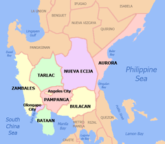
 Map of Aurora with Baler highlighted | ||
.svg.png) Baler Location within the Philippines | ||
| Coordinates: 15°45′30″N 121°33′45″E / 15.75833°N 121.5625°ECoordinates: 15°45′30″N 121°33′45″E / 15.75833°N 121.5625°E | ||
| Country |
| |
| Region | Central Luzon (Region III) | |
| Province | Aurora | |
| District | Lone District | |
| Founded | 19 August 1609 | |
| Barangays |
List
| |
| Government [1] | ||
| • Type | Sangguniang Bayan | |
| • Mayor | Nelianto C. Bihasa | |
| • Vice Mayor | Pedro M. Ong, Jr. | |
| • Electorate | 22,535 voters (2016) | |
| Area [2] | ||
| • Total | 92.55 km2 (35.73 sq mi) | |
| Population (2015 census)[3] | ||
| • Total | 39,562 | |
| • Density | 430/km2 (1,100/sq mi) | |
| Time zone | UTC+8 (PST) | |
| ZIP code | 3200 | |
| PSGC | 037701000 | |
| IDD : area code | +63 (0)42 | |
| Climate type | Tropical rainforest climate | |
| Income class | 3rd municipal income class | |
| Revenue (₱) | 119,516,531.08 (2016) | |
| Native languages |
Northern Alta Tagalog | |
| Website |
www | |

Baler, officially the Municipality of Baler (Filipino: Bayan ng Baler; Ilokano: Ili ti Baler), is a municipality and capital of the province of Aurora, Philippines. According to the 2015 census, it has a population of 39,562 people.[3]
Baler is located 231 kilometres (144 mi) north-east of Manila via a mountain pass accessible by bus and private vehicle. It is host to spectacular geographic formations and is situated on a vast plain at the south end of Baler Bay, a contiguous segment of the Philippine Sea.
It became the capital of Aurora on 14 June 1951 under Republic Act No. 648[4] signed by President Elpidio Quirino. It remained the seat of government of Aurora on 21 November 1978 under Batas Pambansa Blg. 7[5] signed by President Ferdinand Marcos.
History
Spanish colonial period
.jpg)
In 1609, seven Franciscan missionaries, led by Fray Blas Palomino, founded the settlement of Baler, which was later converted into a pueblo (town) by the Augustinians and the Recollects in 1658. Due to scarcity of religious missionaries, the Franciscans again took over the administration of the settlement in 1703.
On 27 December 1735, a great storm came and a huge wave called tromba marina devastated the old town settlement, then located in Barrio Sabang. Among the survivors were the Angaras, Bijasas, Bitongs, Lumasacs, Carrascos, and Pobletes who swam toward the nearby Ermita Hill.[6] A new community sprang into what is now the Poblacion of Baler, leaving "Kinagunasan," the place of devastation. A mural depicting this wave can be found in the Museo de Baler in town.
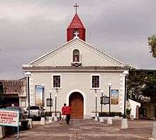
On 27 June 1898, 15 days after the Philippine Declaration of Independence, 54 Spanish soldiers of the Baler garrison, under the command of Captain Enrique de las Morenas y Fossi, made San Luis Obispo de Tolosa Church, named in Spanish for Louis of Toulouse, their barracks. When de las Morenas died on 22 November 1898, Lieutenant Saturnino Martín Cerezo replaced him. On 2 June 1899, the last Spanish garrison in the Philippines surrendered after the Siege of Baler, effectively ending over 300 years of Spanish rule in the country.[7]
American colonial period
In 1901, the Americans incorporated the town into the province of Tayabas (later named Quezon province). Before the Americans came, Baler was under the district of El Príncipe.
The Comedia de Baler of Aurora mounted its first production in 1927. It was supported by then President Manuel L. Quezon and enjoyed the collaboration of artists Fortunato Esoreña and Alejandro Ferreras and arnis expert Antonino Ramos. Still alive until today, it features a group of colorfully attired performers using authentic weapons, like swords and knives, in their plays.
Japanese occupation
In 1942, the Imperial Japanese Army entered Baler, where they made the Baler Elementary School building as their garrison under the command of a certain Captain Hattori. The general headquarters and camp base of the Philippine Commonwealth Army from 3 January 1942 to 30 June 1946 and the Philippine Constabulary from 28 October 1944 to 30 June 1946 were stationed in Baler. In 1945, Filipino and American troops landed in Baler, including Filipino troops of the 3rd Infantry Division, the 5th Infantry Division, the 51st Infantry Division, and the 52nd Infantry Division of the Philippine Commonwealth Army, the 5th Constabulary Regiment of the Philippine Constabulary, the local recognized guerrilla unit, and the American troops of the 6th Infantry Division of the United States Army. The retreating Japanese troops destroyed the San Luis Obispo de Tolosa Church in Baler.
Post-war period
On 14 June 1951, by virtue of Republic Act No. 648, Baler became the capital town of the sub-province (and later, province) of Aurora.[8]
In 1956, the barrio of Dingalan was converted into a municipal district within Baler and later became a town in its right.[9]
Geography
Baler is located at 15°45′30″N 121°33′45″E / 15.75833°N 121.5625°E.
According to the Philippine Statistics Authority, the municipality has a land area of 92.55 square kilometres (35.73 sq mi) [2] constituting 2.94% of the 3,147.32-square-kilometre- (1,215.19 sq mi) total area of Aurora.
Barangays
Baler is politically subdivided into 13 barangays.[10]
| PSGC | Barangay | Population | ±% p.a. | |||
|---|---|---|---|---|---|---|
| 2015[3] | 2010[11] | |||||
| 037701001 | Barangay I (Poblacion) | 1.5% | 587 | 717 | −3.74% | |
| 037701002 | Barangay II (Poblacion) | 0.8% | 312 | 374 | −3.39% | |
| 037701003 | Barangay III (Poblacion) | 0.9% | 357 | 434 | −3.65% | |
| 037701004 | Barangay IV (Poblacion) | 0.9% | 363 | 389 | −1.31% | |
| 037701005 | Barangay V (Poblacion) | 4.3% | 1,718 | 1,662 | 0.63% | |
| 037701006 | Buhangin | 13.4% | 5,310 | 5,057 | 0.93% | |
| 037701007 | Calabuanan | 9.8% | 3,895 | 3,221 | 3.68% | |
| 037701008 | Obligacion | 3.1% | 1,215 | 1,135 | 1.31% | |
| 037701009 | Pingit | 14.9% | 5,913 | 4,989 | 3.29% | |
| 037701010 | Reserva | 11.6% | 4,580 | 4,064 | 2.30% | |
| 037701011 | Sabang | 12.2% | 4,833 | 4,829 | 0.02% | |
| 037701012 | Suclayin | 16.0% | 6,341 | 5,923 | 1.31% | |
| 037701013 | Zabali | 10.5% | 4,138 | 3,216 | 4.92% | |
| Total | 39,562 | 36,010 | 1.81% | |||
Climate
| Climate data for Baler, Aurora (1995–2010, extremes 1949–2012) | |||||||||||||
|---|---|---|---|---|---|---|---|---|---|---|---|---|---|
| Month | Jan | Feb | Mar | Apr | May | Jun | Jul | Aug | Sep | Oct | Nov | Dec | Year |
| Record high °C (°F) | 33.3 (91.9) |
35.0 (95) |
35.8 (96.4) |
37.5 (99.5) |
38.6 (101.5) |
38.8 (101.8) |
41.2 (106.2) |
37.0 (98.6) |
37.0 (98.6) |
35.5 (95.9) |
34.2 (93.6) |
33.9 (93) |
41.2 (106.2) |
| Average high °C (°F) | 27.6 (81.7) |
28.3 (82.9) |
29.6 (85.3) |
30.9 (87.6) |
31.0 (87.8) |
31.4 (88.5) |
31.1 (88) |
31.2 (88.2) |
31.2 (88.2) |
30.5 (86.9) |
29.4 (84.9) |
27.8 (82) |
30.0 (86) |
| Daily mean °C (°F) | 24.5 (76.1) |
24.9 (76.8) |
25.9 (78.6) |
27.1 (80.8) |
27.4 (81.3) |
27.9 (82.2) |
27.6 (81.7) |
27.8 (82) |
27.6 (81.7) |
27.1 (80.8) |
26.2 (79.2) |
24.8 (76.6) |
26.6 (79.9) |
| Average low °C (°F) | 21.3 (70.3) |
21.5 (70.7) |
22.3 (72.1) |
23.3 (73.9) |
23.9 (75) |
24.4 (75.9) |
24.1 (75.4) |
24.3 (75.7) |
24.0 (75.2) |
23.7 (74.7) |
22.9 (73.2) |
21.9 (71.4) |
23.1 (73.6) |
| Record low °C (°F) | 14.3 (57.7) |
15.3 (59.5) |
17.1 (62.8) |
17.7 (63.9) |
20.0 (68) |
20.0 (68) |
20.0 (68) |
20.0 (68) |
19.6 (67.3) |
18.3 (64.9) |
17.1 (62.8) |
16.1 (61) |
14.3 (57.7) |
| Average rainfall mm (inches) | 220.2 (8.669) |
179.1 (7.051) |
185.0 (7.283) |
215.4 (8.48) |
329.1 (12.957) |
238.8 (9.402) |
272.7 (10.736) |
164.9 (6.492) |
282.1 (11.106) |
386.0 (15.197) |
368.7 (14.516) |
405.9 (15.98) |
3,247.9 (127.87) |
| Average rainy days (≥ 0.1 mm) | 16 | 14 | 14 | 14 | 16 | 16 | 17 | 15 | 15 | 18 | 16 | 15 | 186 |
| Average relative humidity (%) | 86 | 86 | 85 | 85 | 85 | 84 | 83 | 83 | 83 | 85 | 85 | 86 | 85 |
| Source: PAGASA[12][13] | |||||||||||||
Officials
The Current Officials of Baler, Aurora (as of May 19, 2016)[14]
| Name | Designation |
|---|---|
| Nelianto Carrasco Bihasa | Mayor |
| Pedro Montes Ong Jr. | Vice Mayor |
| Noel Pablo Go | Member Sangguniang Bayan |
| Carlito Sindac Morillo | Member Sangguniang Bayan |
| Gina Trinidad Ritual | Member Sangguniang Bayan |
| Emmanuel Limpin Galban | Member Sangguniang Bayan |
| Reynaldo Esteban Mapindan | Member Sangguniang Bayan |
| Francisco Barangan Zubia III | Member Sangguniang Bayan |
| Felipe Morada Friginal | Member Sangguniang Bayan |
| Ramir Delos Santos Duaso | Member Sangguniang Bayan |
Demographics
| Population census of Baler | ||
|---|---|---|
| Year | Pop. | ±% p.a. |
| 1903 | 2,417 | — |
| 1918 | 3,413 | +2.33% |
| 1939 | 11,887 | +6.12% |
| 1948 | 17,182 | +4.18% |
| 1960 | 10,350 | −4.14% |
| 1970 | 14,632 | +3.52% |
| 1975 | 16,046 | +1.87% |
| 1980 | 18,349 | +2.72% |
| 1990 | 24,689 | +3.01% |
| 1995 | 26,919 | +1.63% |
| 2000 | 29,923 | +2.29% |
| 2007 | 34,492 | +1.98% |
| 2010 | 36,010 | +1.58% |
| 2015 | 39,562 | +1.81% |
| Source: Philippine Statistics Authority[3] [11] [15] [16] | ||
People with connections to the town are referred to as Balerenos. Prior to the arrival of Spanish missionaries in Baler in 1609, settlements by Aeta people and Ilongot in Baler's coast and mountain areas already exists. Tagalogs, some originating from Palanan and Infanta, Quezon, came in to the area to trade by boat. Some Tagalogs settled in Baler and married with the Aeta and Ilongots.[17]
The Spanish brought in Filipino acolytes from other areas of Luzon from 1609 to 1899. During this period, Baler can only be access by sea though the town saw increase migration from other parts of Luzon such as Laguna, Tayabas, and Bicol from the south. The opening of the Baler-Bongabon Road allowed easier migration of people from Ilocos and Isabela areas from the north. The road also allowed Igorot people and Batangueños to settle in Baler.[17]
In the 2015 census, Baler had a population of 39,562.[3] The population density was 430 inhabitants per square kilometre (1,100/sq mi).
Culture
Baler annually observes the Philippine–Spanish Friendship Day which commemorates the end of the historic Siege of Baler[18] and celebrates Philippines–Spain relations developed since then.[19] It is usually held every June 30 and the rites which was first done in the provincial capital has also been observed in other parts of the country as well as parts of Spain.[18]
Notable people
- Manuel L. Quezon, first President of the Commonwealth of the Philippines
- Aurora Quezon, former First Lady of the Philippines, wife of Commonwealth President Manuel L. Quezon
- Eunice Pablo Guerrero-Cucueco, the first female governor of Aurora province
- Loreto Bihasa, a veteran whose exploits in the Korean War was made into a movie starring Vic Vargas
- Edgardo Angara, former Senate President, former University of the Philippines president and longest-serving senator in the Philippines.
- Bella Angara, the first and the only woman in the history of the Philippine Congress to become house majority floor leader
- Sonny Angara, one of the recipients of the Ten Outstanding Young Men (TOYM) Awards for 2010, who received his trophy from President Benigno Aquino III, former President of the Philippines.
Gallery
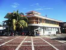
 Baler Public Market
 Outer Banks, Labasin‑Sabang Beach
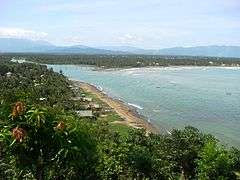 View of Baler Bay from Ermita Hill
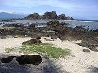 Rocky islets in Diguisit Bay
 Dicasalarin Cove
References
- ↑ "Municipality". Quezon City, Philippines: Department of the Interior and Local Government. Retrieved 31 May 2013.
- 1 2 "Province: Aurora". PSGC Interactive. Quezon City, Philippines: Philippine Statistics Authority. Retrieved 12 November 2016.
- 1 2 3 4 5 Census of Population (2015). "Region III (Central Luzon)". Total Population by Province, City, Municipality and Barangay. PSA. Retrieved 20 June 2016.
- ↑ "Republic Act No. 648 - An Act Creating The Subprovince Of Aurora, Which Shall Comprise The Municipalities Of Baler, Casiguran, Dipaculao And Maria Aurora, Province Of Quezon". Chan Robles Virtual Law Library. 14 June 1951. Archived from the original on 24 April 2016.
- ↑ "Batas Pambansa Blg. 7 - An Act Separating the Sub-Province of Aurora from the Province of Quezon and Establishing It as an Independent Province". Chan Robles Virtual Law Library. 21 November 1978. Archived from the original on 3 March 2016. Retrieved 5 November 2016.
- ↑ GOVPH. "National Historical Commission of the Philippines - "A Filipino society with citizens informed of their history, who love their country and are proud of their cultural heritage."". Nhcp.gov.ph. Retrieved 5 November 2016.
- ↑ Hernandez, Miguel. "The Last Action of the Spanish American War: The Siege of Baler". The Spanish American War Centennial Website. Archived from the original on 30 July 2016. Retrieved 5 November 2016.
- ↑ "Republic Act No. 648; An Act Creating the Subprovince of Aurora, Which Shall Comprise the Municipalities of Baler, Casiguran, Dipaculao and Maria Aurora, Province of Quezon". PhilippineLaw.info. 14 June 1951. Archived from the original on 3 May 2012. Retrieved 5 November 2016.
- ↑ "Republic Act No. 1536; An Act Creating the Municipal District of Dingalan in the Municipality of Baler, Subprovince of Aurora, Province of Quezon". PhilippineLaw.info. 16 June 1956. Archived from the original on 3 May 2012. Retrieved 5 November 2016.
- ↑ "Municipal: Baler, Aurora". PSGC Interactive. Quezon City, Philippines: Philippine Statistics Authority. Retrieved 8 January 2016.
- 1 2 Census of Population and Housing (2010). "Region III (Central Luzon)". Total Population by Province, City, Municipality and Barangay. NSO. Retrieved 29 June 2016.
- ↑ "Baler, Aurora Climatological Normal Values". Philippine Atmospheric, Geophysical and Astronomical Services Administration. Archived from the original on 23 September 2018. Retrieved 23 September 2018.
- ↑ "Baler, Aurora Climatological Extremes". Philippine Atmospheric, Geophysical and Astronomical Services Administration. Archived from the original on 23 September 2018. Retrieved 23 September 2018.
- ↑ "Government Officials of Aurora, Philippines". Retrieved 21 February 2018.
- ↑ Censuses of Population (1903–2007). "Region III (Central Luzon)". Table 1. Population Enumerated in Various Censuses by Province/Highly Urbanized City: 1903 to 2007. NSO.
- ↑ "Province of Aurora". Municipality Population Data. Local Water Utilities Administration Research Division. Retrieved 17 December 2016.
- 1 2 Mesina, Ilovita. "Baler And Its Poeple, The Aurorans". Aurora.ph. Retrieved 21 February 2018.
- 1 2 Galvez, Manny (2 July 2010). "RP-Spain Friendship Day marked today in Bale". The Philippine Star. Retrieved 21 February 2018.
- ↑ Quismundo, Tarra (5 July 2016). "Filipino, Spanish officials mark Friendship Day in Baler, Aurora". Philippine Daily Inquirer. Retrieved 21 February 2018.
External links
| Wikivoyage has a travel guide for Baler. |
| Wikimedia Commons has media related to Baler, Aurora. |
Places adjacent to Baler, Aurora | |
|---|---|