Tawi-Tawi
| Tawi-Tawi | |||
|---|---|---|---|
| Province | |||
| Province of Tawi-Tawi | |||
| |||
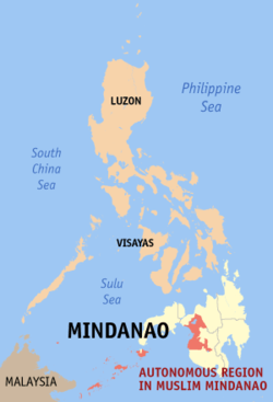
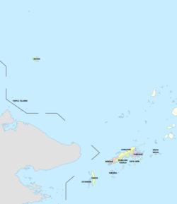
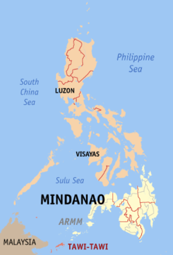 Location in the Philippines | |||
| Coordinates: 5°12′00″N 120°05′00″E / 5.2°N 120.0833333°ECoordinates: 5°12′00″N 120°05′00″E / 5.2°N 120.0833333°E | |||
| Country | Philippines | ||
| Region | Autonomous Region in Muslim Mindanao (ARMM) | ||
| Founded | September 11, 1973 | ||
| Capital | Bongao | ||
| Government | |||
| • Type | Sangguniang Panlalawigan | ||
| • Governor | Rashidin Matba | ||
| • Vice Governor | Tati Ahaja (Liberal Party) | ||
| Area[1] | |||
| • Total | 1,087.40 km2 (419.85 sq mi) | ||
| Area rank | 74th out of 81 | ||
| Highest elevation (Mount Sibangkat [2]) | 535 m (1,755 ft) | ||
| Population (2015 census)[3] | |||
| • Total | 390,715 | ||
| • Rank | 63rd out of 81 | ||
| • Density | 360/km2 (930/sq mi) | ||
| • Density rank | 18th out of 81 | ||
| Divisions | |||
| • Independent cities | 0 | ||
| • Component cities | 0 | ||
| • Municipalities | |||
| • Barangays | 203 | ||
| • Districts | Lone district of Tawi-Tawi | ||
| Time zone | UTC+8 (PHT) | ||
| ZIP code | 7500–7509 | ||
| IDD : area code | +63 (0)68 | ||
| ISO 3166 code | PH | ||
| Spoken languages | |||
| Income classification | 3rd class | ||


Tawi-Tawi (Tausug: Wilāya sin Tawi-Tawi) is an island province in the Philippines located in the Autonomous Region in Muslim Mindanao (ARMM). The capital of Tawi-Tawi is Bongao, per Batas Pambansa Blg. 24 enacted on April 4, 1979.[4]
It is the southernmost province of the country, sharing sea borders with the Malaysian state of Sabah and the Indonesian North Kalimantan province, both on the island of Borneo to the west. To the northeast lies the province of Sulu. Tawi-Tawi also covers some islands in the Sulu Sea to the northwest, the Cagayan de Tawi-Tawi Island and the Turtle Islands, just 20 kilometres (12 mi) away from Sabah.
Etymology
Province was named after its main island. Tawi-Tawi is the Sinama form of jawi-jawi, Malay for "banyan tree;"[5] the island is known for having an abundance of this tree.[6] Early Spanish accounts give the name of the island as Tauitaui,[7] Tavi-Tavi or Tavitavi.[8]
History
Evidence of human presence in Tawi-tawi was carbon-dated to be 6,810 BC to 3,190 BC, signifying one of the earliest known evidence of human presence in Southeast Asia. The bones, jars, shells, and other artifacts and fossils were found in the Bolobok Rock Shelter Cave Archaeological Site, which has been declared as an Important Cultural Treasure by the government in 2017.[9]
Much of the Tawi-tawi area was the center of Bajau culture and arts for hundreds of years. By the 600th century, Muslim missionaries from Arabia arrived and established the first ever mosque in the Philippines. The area was heavily converted to Islam, especially when the Sultanate of Sulu in nearby Sulu province was founded.
Tawi-Tawi became one of the three integral provinces of the Sultanate of Sulu during its inception and became of its strongest domains in its twilight years. The sultanate's influence of the area have remained to this day, despite the de facto status of the sultanate due to Philippine pressures.
The province was never officially controlled directly by the Spanish as the Sultanate of Sulu was in a perpetual war with Spain, resulting to the preservation of its Muslim and Bajau cultures. However, the sultanate waned and was captured by Spain, only to be handed to American forces after a few years. Sibutu remained under Spanish rule until 1900.
The Tawi-Tawi anchorage was a major base for the Imperial Japanese Navy's Southwest Area Fleet during the Second World War.
Tawi-Tawi was previously part of the province of Sulu. On September 11, 1973, pursuant to Presidential Decree No. 302, the new province of Tawi-Tawi was officially created, separate from Sulu.[10] The seat of the provincial government was initially designated as Bato-Bato in the municipality of Balimbing,[10] but was moved to Bongao on April 4, 1979 by virtue of Batas Pambansa Blg. 24.[4]
Geography
The province lies at the southwestern tip of the country, situated between the Sulu Sea in the north and the Celebes Sea in the south. The province is part of the Sulu Archipelago, and consists of Tawitawi Island and 106 surrounding islands and islets with a combined land area of 1,087.4 square kilometres (419.8 square miles).[1] Tawitawi Island itself has an area of 580.5 square kilometres (224.1 square miles).[11]. The last island of the province at the edge of the Philippine-Malaysia border is Panguan Island.
The province has two seasons: dry and wet. The climate is generally moderate. The wettest months are from August to November. The other months of the year are generally dry with occasional rain showers.[12]
Biogeography
The main island of Tawi-Tawi supports many endemic species and subspecies of vertebrates, invertebrates and plants unique to this island, plus some that are only shared with Sulu Province. These include the Tawitawi brown dove, the Sulu hornbill and the Sulu bleeding-heart, although this latter species may already be extinct.
The rapid expansion of human settlements into forested areas together with clearance for agriculture in the last few decades has dramatically reduced the available habitat for most of the endemic species, many of which are now considered 'Critically Endangered' by the International Union for the Conservation of Nature.
Administrative divisions
Tawi-Tawi comprises 11 municipalities, all encompassed by a single legislative district and further subdivided into 203 barangays.[13]
- Bongao — the capital of the province
- Languyan — created by President Marcos for rebel leader Hadjiril Matba who joined the government in the 1970s
- Mapun — formerly Cagayan de Tawi-Tawi or Cagayan de Sulu
- Panglima Sugala — formerly known as Balimbing. However, in the EDSA Revolution, the word "balimbing" acquired a derogatory meaning associated with turncoatism due to the fruit's many sides. It is the former capital of the province.
- Sapa-Sapa
- Sibutu — home to the descendants of Malay royalty in Borneo and not necessarily associated with the Sulu royalty
- Simunul — site of oldest mosque in the Philippines and home of Sheikh Makdum, one of the early pioneers spreading Islam in the country
- Sitangkai — southernmost municipality in the country.
- South Ubian
- Tandubas
- Turtle Islands — a turtle sanctuary and protected area
Most of the municipalities are located on the islands in the Sulu Archipelago. Two of them, Mapun, and Turtle Islands lie within the Sulu Sea.
|
† Provincial capital
|
| ||||||||||||||||||||||||||||||||||||||||||||||||||||||||||||||||||||||||||||||||||||||||||||||||||||||||||||||||||||||||||||||||||||||||||||||||||||||||||||||||||||||||||||||||||||
Demographics
| Population census of Tawi-Tawi | ||
|---|---|---|
| Year | Pop. | ±% p.a. |
| 1980 | 194,651 | — |
| 1990 | 228,204 | +1.60% |
| 1995 | 250,718 | +1.78% |
| 2000 | 322,317 | +5.53% |
| 2007 | 450,346 | +4.72% |
| 2010 | 366,550 | −7.22% |
| 2015 | 390,715 | +1.22% |
| Source: Philippine Statistics Authority[3][14][17] | ||
The population of Tawi-Tawi in the 2015 census was 390,715 people,[18] with a density of 360 inhabitants per square kilometre or 930 inhabitants per square mile.
Inhabitants
Most of the people in Tawi-Tawi belong to the Sama cultural group.[12] Within this group are subgroups and named based on the location of the speaker. Sama Sibutu are those from the Sibutu-Sitangkai Island Group, Sama Simunul are those from Simunul-Manuk Mangkaw Island Group, and so on.
The Jama Mapun are largely found in the Cagayan Mapun and Turtle Island Group. Many of the people from the Turtle Islands and Cagayan Mapun maintain daily commerce with Sabah, since it is only 14 kilometers away.
The Badjao (also called "Sama Dilaut") are widely dispersed across the province, though their population is diminishing due to diseases and migration to other areas in the Philippines, Malaysia and Indonesia.
The Tausog or Tau Sug, Orang Suluk or Aa Suk are a Moro ethnic group constituting a significant minority in Tawi-Tawi. Historically the Sama people were subordinated to the Tausog and ethnic tensions continue to be a problem.[19]
Language
The prevailing local language is the indigenous Bahasa Sama which is widely used in varied tones and accents. This variety led to the development of Sinama dialects. The major ones are Sinama Sibutu (spoken mainly in the Sibutu-Sitangkai Region), Sinama Simunul (concentrated in Simunul-Manuk-Mangkaw Islands), Sinama Kapoan (spoken in the South Ubian-Tandubas and Sapa-Sapa Regions) and Sinama Banguingui (concentrated in Buan Island and spoken by Banguingui people).
The Βajau-Ѕama language is also spoken, as are English and Filipino (Tagalog). Many locals and barter traders can speak Malay and Indonesian. Chavacano is also spoken by Christian and Muslim locals who maintain contacts and trade with the mainland Zamboanga Peninsula and Basilan, as Tawi-tawi and Sulu, were partially ruled by the Spanish as their sovereignty was limited to military stations and garrisons and pockets of civilian settlements, until they had to abandon the region as a consequence of their defeat in the Spanish–American War. The Tausug language is however the lingua franca of Tawi-Tawi, as in the case of the rest of the provinces in the Sulu Archipelago. The rest of Muslims speak Cebuano because of the mass influx of Cebuano settlers to Mindanao and they all speak Tausug language since it is a Visayan language.
Religion
Majority of population of Tawi-Tawi is Muslim with 99% adherence, with minority of Christians (0.7%).
A majority of Tawi-Tawi's Muslim population practice Sunni Islam of the Shafi'i tradition, as taught by Arab, Persian, Indian Muslim, Chinese Muslim and Malaccan missionaries from the 14th century onwards. The oldest mosque in the Philippines, the Sheik Karimol Makdum Mosque, can be found in Simunul, Tawi-Tawi.
Relatively newer Islamic sects, mostly brought by returning veterans of the Afghan wars and missionaries from Pakistan's stricter Sufi traditions, referred to as the Tableegh, have been active in propagating what they believe to be a "purer" Islamic way of life and worship. A very small number who have since married into Iranian or Iraqi families have converted to Shiite Islam.
Majority of Tawi-Tawi Christians are Roman Catholic, they are under the jurisdiction of Roman Catholic Archdiocese of Zamboanga through its suffragan Apostolic Vicariate of Jolo/Diocese of Jolo. Non-Catholic Christians include Evangelicals, Jesus Miracle Crusade, Episcopalian, and Iglesia ni Cristo (INC), Mormons, Seventh-day Adventists, Jehovah's Witnesses, and a number of other Protestant denominations. Only the most recent Chinese immigrants adhere to Buddhism or Taoism, while most of the older Chinese families have acculturated and have either converted to Christianity or Islam while retaining most of their Chinese beliefs.
Economy
Agriculture, fishing, and agar-agar (seaweeds) farming are the leading source of livelihood of the people of Tawi-Tawi, with quite a number engaged in the barter trade business. Copra is the top agricultural product, followed by root crops, fruits, and vegetables.
Transportation
Sanga-Sanga Airport, the main airport of the province, is located in the municipality of Bongao.
Cebu Pacific began operating a daily flight from Zamboanga City to Tawi-Tawi Province on October 14, 2011, utilizing its 150-seater Airbus A319 aircraft. In 2012, Philippine Airlines (operated by PAL Express) also started operating flights to and from Zamboanga city but ceased operations thereafter.
A sea connection to other parts of the Philippine archipelago as well as an international route to Semporna, Malaysia is available from Bongao.
See also
References
- 1 2 Autonomous Region in Muslim Mindanao, Department of Agriculture: Tawi-Tawi Archived 2012-09-06 at the Wayback Machine. (There seems to be major discrepancies among authoritative sources: 362,655 ha (NSCB 2007), 120,876 ha (NAMRIA), 1,197 square kilometres (462 square miles) (Department of Tourism), 999 square kilometres (386 square miles) (Mapcentral))
- ↑ Malicdem, Ervin (7 June 2017). "Bud Bongao, Tawi-Tawi's Overwatch and Sacred Peak". Schadow1 Expeditions. Retrieved 15 August 2017.
- 1 2 3 Census of Population (2015). Highlights of the Philippine Population 2015 Census of Population. PSA. Retrieved 20 June 2016.
- 1 2 3 Batasang Pambansa ng Pilipinas (4 April 1979). "Batas Pambansa Bilang 24 - AN ACT TRANSFERRING THE PROVINCIAL CAPITAL OF TAWI-TAWI FROM BATO-BATO TO BONGAO, AMENDING SECTION TWO OF PRESIDENTIAL DECREE NUMBERED THREE HUNDRED TWO". Chan Robles Law Library. Retrieved 12 August 2016.
- ↑ Crawfurd, John (1852). A Grammar and Dictionary of the Malay Language: With a Preliminary Dissertation, Volume 2. Smith, Elder & Co. p. 59.
- ↑ United States Congress (1907). Congressional edition, Volume 5113. United States Government Printing Office.
- ↑ Combes, Francisco (1667). Historia de las islas de Mindanao, Jolo y sus adyacentes. Herederos de Pablo de Val.
- ↑ Pio A. De Pazos y Vela-Hidalgo (ed.). Jolo, Relato Historico-Militar: Desde Su Descubrimiento Por Los Espanoles en 1578 A Nuestros Dias (1879). Imprenta y Estereotipia de Polo.
- ↑ http://www.ironwulf.net/2009/03/19/tawi-tawi-balobok-rock-shelter/
- 1 2 "Presidential Decree No. 302; Creating the Province of Tawi-Tawi". The LawPhil Project. 27 September 1973. Retrieved 13 January 2016.
- ↑ "Islands of Philippines". Island Directory. United Nations Environment Programme. Retrieved 29 August 2014.
- 1 2 "Tawi Tawi". www.britannica.com. Encyclopædia Britannica, Inc. Retrieved 29 August 2014.
- 1 2 3 "Province: Tawi-Tawi". PSGC Interactive. Quezon City, Philippines: Philippine Statistics Authority. Retrieved 8 January 2016.
- 1 2 Census of Population and Housing (2010). Population and Annual Growth Rates for The Philippines and Its Regions, Provinces, and Highly Urbanized Cities (PDF). NSO. Retrieved 29 June 2016.
- ↑ "PSGC Interactive; List of Provinces". Philippine Statistics Authority. Retrieved 18 April 2016.
- ↑ "DA-Tawi-Tawi". Department of Agriculture and Fisheries - Autonomous Region in Muslim Mindanao. Archived from the original on 6 September 2012. Retrieved 18 April 2016.
Total Land Area; 108, 740 has.
- ↑ Census of Population and Housing (2010). "ARMM – Autonomous Region in Muslim Mindanao". Total Population by Province, City, Municipality and Barangay. NSO. Retrieved 29 June 2016.
- ↑ Census of Population (2015). "ARMM – Autonomous Region in Muslim Mindanao". Total Population by Province, City, Municipality and Barangay. PSA. Retrieved 20 June 2016.
- ↑ Rosaldo, Renato, ed. (2003). Citizenship in Island Southeast Asia: Nation and Belonging in the Hinterlands. University of California Press. ISBN 9780520227484. Retrieved 15 March 2013.
External links


Places adjacent to Tawi-Tawi | ||||||||||
|---|---|---|---|---|---|---|---|---|---|---|
| ||||||||||
Bongao (capital) | |
| Municipalities | |