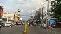
Alaminos, Pangasinan
| Alaminos | ||
|---|---|---|
| Component City | ||
| City of Alaminos | ||
 | ||
| ||
| Nickname(s): The Hundred Islands | ||
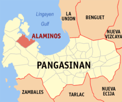 Map of Pangasinan with Alaminos highlighted | ||
.svg.png) Alaminos Location within the Philippines | ||
| Coordinates: 16°09′37″N 119°58′49″E / 16.1603°N 119.9803°ECoordinates: 16°09′37″N 119°58′49″E / 16.1603°N 119.9803°E | ||
| Country |
| |
| Region | Ilocos Region (Region I) | |
| Province | Pangasinan | |
| District | 1st district of Pangasinan | |
| Founded | 1744 | |
| Cityhood | March 28, 2001 | |
| Barangays | 39 (see Barangays) | |
| Government [1] | ||
| • Type | Sangguniang Panlungsod | |
| • Mayor | Arthur Celeste | |
| • Vice Mayor | Anton Perez | |
| • Electorate | 49,503 voters (2016) | |
| Area [2] | ||
| • Total | 164.26 km2 (63.42 sq mi) | |
| Population (2015 census)[3] | ||
| • Total | 89,708 | |
| • Density | 550/km2 (1,400/sq mi) | |
| Time zone | UTC+8 (PST) | |
| ZIP code | 2404 | |
| PSGC | 015503000 | |
| IDD : area code | +63 (0)75 | |
| Climate type | Tropical monsoon climate | |
| Income class | 4th city income class | |
| Revenue (₱) | 436,194,824.58477,774,464.01 [4] | |
| Poverty incidence | 8.61 (2012)[5] | |
| Native languages |
Pangasinan Ilocano Tagalog | |
| Website |
www | |

Alaminos, officially the City of Alaminos, (Pangasinan: Siyudad na Alaminos; Ilokano: Siudad ti Alaminos; Tagalog: Lungsod ng Alaminos), is a city in the province of Pangasinan, Philippines, and is known for being the home of the Hundred Islands National Park, which is composed of 124 islands and is located off the coast of Barangay Lucap. Alaminos is classified as a 4th class city. According to the 2015 census, it has a population of 89,708 people.[3] The city was named after Juan Alaminos y de Vivar, former Governor-General of the Philippines.
The Communist Party of the Philippines was founded by Jose Maria Sison in the remote barangay of Dulacac on December 26, 1968.[6]
Alaminos was badly hit in May 2009 by Typhoon Emong which damaged a lot of houses in the city, including the roof of the main church. Due to this, several organizations had requested donations and aid to help in restoring the town back to its former self.
The Alaminos Airport is currently being built near the city to service the local area.[7]
Barangays
Alaminos City is politically subdivided into 39 barangays.
- Alos
- Amandiego
- Amangbangan
- Balangobong
- Balayang
- Bisocol
- Bolaney
- Baleyadaan
- Bued
- Cabatuan
- Cayucay
- Dulacac
- Inerangan
- Landoc
- Linmansangan
- Lucap
- Maawi
- Macatiw
- Magsaysay
- Mona
- Palamis
- Pandan
- Pangapisan
- Poblacion
- Pocal-Pocal
- Pogo
- Polo
- Quibuar
- Sabangan
- San Antonio
- San Jose
- San Roque
- San Vicente
- Santa Maria
- Tanaytay
- Tangcarang
- Tawintawin
- Telbang
- Victoria
Demographics
| Population census of Alaminos City | |||||||||||||||||||||||||||||||||||||||||||||||||
|---|---|---|---|---|---|---|---|---|---|---|---|---|---|---|---|---|---|---|---|---|---|---|---|---|---|---|---|---|---|---|---|---|---|---|---|---|---|---|---|---|---|---|---|---|---|---|---|---|---|
|
| ||||||||||||||||||||||||||||||||||||||||||||||||
| Source: Philippine Statistics Authority[3] [8] [9] | |||||||||||||||||||||||||||||||||||||||||||||||||
Festivals
The Galila Hundred Islands Festival is held from March 16 to March 21 every year.[10][11] Galila means “come” in the vernacular, and the festival includes the 100 Islands Adventure Race.
The Paraw Festival is a festival held in Alaminos City. The paraw is a double outrigger sail boat native to the Visayas region of the Philippines. It is similar to a proa, but the paraw has two outriggers or katig.
Climate
| Climate data for Alaminos City | |||||||||||||
|---|---|---|---|---|---|---|---|---|---|---|---|---|---|
| Month | Jan | Feb | Mar | Apr | May | Jun | Jul | Aug | Sep | Oct | Nov | Dec | Year |
| Average high °C (°F) | 31 (88) |
31 (88) |
33 (91) |
34 (93) |
34 (93) |
33 (91) |
32 (90) |
31 (88) |
31 (88) |
32 (90) |
31 (88) |
31 (88) |
32 (90) |
| Average low °C (°F) | 21 (70) |
21 (70) |
23 (73) |
25 (77) |
25 (77) |
25 (77) |
25 (77) |
24 (75) |
24 (75) |
24 (75) |
23 (73) |
22 (72) |
24 (74) |
| Average rainfall mm (inches) | 4.3 (0.169) |
19.1 (0.752) |
27.3 (1.075) |
45.2 (1.78) |
153.3 (6.035) |
271.3 (10.681) |
411.1 (16.185) |
532 (20.94) |
364.4 (14.346) |
182.5 (7.185) |
56.3 (2.217) |
24.4 (0.961) |
2,091.2 (82.326) |
| Average rainy days | 3 | 2 | 3 | 5 | 14 | 17 | 22 | 23 | 21 | 13 | 7 | 4 | 134 |
| Source: World Weather Online[12] | |||||||||||||
Sister cities
Images
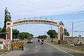 Welcome sign
 Alaminos City Hall (Poblacion)
 Legislative Building (Sangguniang Bayan Session Hall)
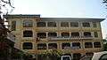 Colegio San Jose de Alaminos (Poblacion)
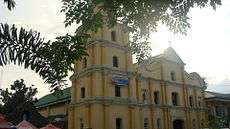 Cathedral of Saint Joseph (Poblacion)
 Uphill, Alaminos City
References
- ↑ "City". Quezon City, Philippines: Department of the Interior and Local Government. Retrieved 30 May 2013.
- ↑ "Province: Pangasinan". PSGC Interactive. Quezon City, Philippines: Philippine Statistics Authority. Retrieved 12 November 2016.
- 1 2 3 Census of Population (2015). "Region I (Ilocos Region)". Total Population by Province, City, Municipality and Barangay. PSA. Retrieved 20 June 2016.
- ↑ "Pangasinan : Cities and Municipalities Competitiveness Index". Makati City, Philippines: National Competitiveness Council (Philippines). Archived from the original on 28 January 2017. Retrieved 28 January 2017.
- ↑ "PSA Releases the 2012 Municipal and City Level Poverty Estimates". Quezon City, Philippines: Philippine Statistics Authority. Archived from the original on 28 January 2017. Retrieved 28 January 2017.
- ↑ Joma Sison recalls birth of CPP in Alaminos - INQUIRER.net, Philippine News for Filipinos Archived 2014-12-26 at the Wayback Machine.
- ↑ http://positivenewsmedia.net/am2/publish/Tourism_24/Alaminos_City_finally_chosen_as_site_of_commercial_airport_in_Pangasinan.shtml
- ↑ Census of Population and Housing (2010). "Region I (Ilocos Region)". Total Population by Province, City, Municipality and Barangay. NSO. Retrieved 29 June 2016.
- ↑ Censuses of Population (1903–2007). "Region I (Ilocos Region)". Table 1. Population Enumerated in Various Censuses by Province/Highly Urbanized City: 1903 to 2007. NSO.
- ↑ Galila Hundred Islands Festival
- ↑ https://www.facebook.com/permalink.php?id=156309794402714&story_fbid=545859105447779
- ↑ "Alaminos, Philippines: Average Temperatures and Rainfall". World Weather Online. Retrieved 15 September 2014.
- ↑ "Alaminos donates goods in Marikina". Balita. September 2009.
External links
| Wikivoyage has a travel guide for Alaminos. |
| Wikimedia Commons has media related to Alaminos, Pangasinan. |
- Official Website of City Government of Alaminos
- City Profile at the National Competitiveness Council of the Philippines
- Alaminos at the Pangasinan Government Website
- Local Governance Performance Management System
- Philippine Standard Geographic Code
- Philippine Census Information
- Pangasinan.org : Alaminos Family and School Reunion Archives
Places adjacent to Alaminos, Pangasinan | |
|---|---|
