San Carlos, Pangasinan
| San Carlos Binalatongan | ||
|---|---|---|
| Component City | ||
| City of San Carlos | ||
 | ||
| ||
| Nickname(s): The Heart of Pangasinan | ||
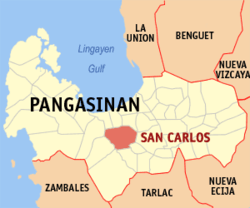 Map of Pangasinan with San Carlos highlighted | ||
.svg.png) San Carlos Location within the Philippines | ||
| Coordinates: 15°55′41″N 120°20′56″E / 15.92806°N 120.34889°ECoordinates: 15°55′41″N 120°20′56″E / 15.92806°N 120.34889°E | ||
| Country |
| |
| Region | Ilocos Region (Region I) | |
| Province | Pangasinan | |
| District | 3rd district of Pangasinan | |
| Founded | 1578 | |
| Cityhood | January 1, 1966 | |
| Barangays | 86 (see Barangays) | |
| Government [1] | ||
| • Type | Sangguniang Panlungsod | |
| • Mayor | Joseres Resuello | |
| • Vice Mayor | Julier Resuello | |
| • Electorate | 96,875 voters (2016) | |
| Area [2] | ||
| • Total | 169.03 km2 (65.26 sq mi) | |
| Population (2015 census)[3] | ||
| • Total | 188,571 | |
| • Density | 1,100/km2 (2,900/sq mi) | |
| Time zone | UTC+8 (PST) | |
| ZIP code | 2420 | |
| PSGC | 015532000 | |
| IDD : area code | +63 (0)75 | |
| Climate type | Tropical monsoon climate | |
| Income class | 3rd city income class | |
| Revenue (₱) | 606,804,968.75 (2016)[4] | |
| Poverty incidence | 15.98 (2012)[5] | |
| Native languages |
Pangasinan Ilocano Tagalog | |
San Carlos City, officially the City of San Carlos, (Pangasinan: Siyudad na San Carlos; Ilokano: Siudad ti San Carlos; Tagalog: Lungsod ng San Carlos), is a 3rd class city in the province of Pangasinan, Philippines. According to the 2015 census, it has a population of 188,571 people.[3]
As the most populated city in Pangasinan and the entire Ilocos Region.
Also known as Binalatongan, it lies in the central plains of the heart of Pangasinan. Its nearby neighbors are Lingayen, Binmaley, Calasiao, Santa Barbara, Malasiqui, Bayambang, Mangatarem, Urbiztondo and Aguilar with bordering Bugallon and Basista.[6]
History
Precolonial times
San Carlos City was once known as Binalatongan and is the capital of the Huangdom of Pangasinan, which includes the present-day towns of Northern Tarlac, La Union, Benguet, Zambales, Nueva Ecija and Nueva Vizcaya. During that time, Pangasinan traded with Japan, China and other Southeast Asian empires and national entities and enjoyed full independence and prosperity.
Barangays
San Carlos City is politically subdivided into 86 barangays.
- Abanon
- M.Soriano St. (Poblacion)
- Agdao
- Anando
- Antipangol
- Aponit
- Bacnar
- Balaya
- Balayong
- Baldog
- Balite Sur
- Balococ
- Bani
- Bocboc
- Bugallon-Posadas Street (Poblacion)
- Bogaoan
- Bolingit
- Bolosan
- Bonifacio (Poblacion)
- Buenglat
- Burgos-Padlan (Poblacion)
- Cacaritan
- Caingal
- Calobaoan
- Calomboyan
- Capataan
- Caoayan-Kiling
- Cobol
- Coliling
- Cruz
- Doyong
- Gamata
- Guelew
- Ilang
- Inerangan
- Isla
- Libas
- Lilimasan
- Longos
- Lucban (Poblacion)
- Mabalbalino
- Mabini (Poblacion)
- Magtaking
- Malacañang
- Maliwara
- Mamarlao
- Manzon
- Matagdem
- Mestizo Norte
- Naguilayan
- Nelintap
- Padilla-Gomez (Poblacion)
- Pagal
- Palaming
- Palaris (Poblacion)
- Palospos
- Pangalangan
- Pangoloan
- Pangpang
- Paitan-Panoypoy
- Parayao
- Payapa
- Payar
- Perez Boulevard (Poblacion)
- PNR Site (Poblacion)
- Polo
- Quezon Boulevard (Poblacion)
- Quintong
- Rizal Avenue (Poblacion)
- Roxas Boulevard (Poblacion)
- Salinap
- San Juan
- San Pedro (Poblacion)
- Sapinit
- Supo
- Talang
- Taloy (Poblacion)
- Tamayo
- Tandoc
- Tarece
- Tarectec
- Tayambani
- Tebag
- Turac
- Ano
- Tandang Sora (Poblacion)
Demographics
| Population census of San Carlos City | ||
|---|---|---|
| Year | Pop. | ±% p.a. |
| 1903 | 27,166 | — |
| 1918 | 35,780 | +1.85% |
| 1939 | 47,334 | +1.34% |
| 1948 | 61,671 | +2.98% |
| 1960 | 73,900 | +1.52% |
| 1970 | 84,333 | +1.33% |
| 1975 | 90,882 | +1.51% |
| 1980 | 101,243 | +2.18% |
| 1990 | 124,529 | +2.09% |
| 1995 | 134,039 | +1.39% |
| 2000 | 154,264 | +3.06% |
| 2007 | 161,884 | +0.67% |
| 2010 | 175,103 | +2.90% |
| 2015 | 188,571 | +1.42% |
| Source: Philippine Statistics Authority[3][7][8][9] | ||
Climate
| Climate data for San Carlos City, Pangasinan | |||||||||||||
|---|---|---|---|---|---|---|---|---|---|---|---|---|---|
| Month | Jan | Feb | Mar | Apr | May | Jun | Jul | Aug | Sep | Oct | Nov | Dec | Year |
| Average high °C (°F) | 31 (88) |
31 (88) |
31 (88) |
33 (91) |
32 (90) |
32 (90) |
30 (86) |
30 (86) |
30 (86) |
31 (88) |
31 (88) |
31 (88) |
31 (88) |
| Average low °C (°F) | 21 (70) |
21 (70) |
22 (72) |
24 (75) |
24 (75) |
24 (75) |
23 (73) |
23 (73) |
23 (73) |
23 (73) |
23 (73) |
22 (72) |
23 (73) |
| Average precipitation mm (inches) | 5.1 (0.201) |
11.6 (0.457) |
21.1 (0.831) |
27.7 (1.091) |
232.9 (9.169) |
350.8 (13.811) |
679.8 (26.764) |
733.1 (28.862) |
505 (19.88) |
176.6 (6.953) |
67.2 (2.646) |
17.7 (0.697) |
2,828.6 (111.362) |
| Average rainy days | 3 | 3 | 3 | 4 | 14 | 18 | 23 | 25 | 22 | 15 | 8 | 4 | 142 |
| Source: World Weather Online[10] | |||||||||||||
Economy
Farming, inland fishing, commerce and trade, small-scale manufacturing, handicraft, pottery, fruit-raising, flour-making, and mango production are the principal products of San Carlos.[11]
Tourism
Interesting spots of the town include:
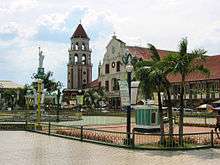
- 424-year-old Saint Dominic de Guzman Parish Church
- Speaker Eugenio Perez Memorial Park
- City Plaza
- Quadricentennial Arch in Bolingit
- Binalatongan Ruins in San Juan
- Philippine Fruit Corporation at Barangay Pagal
Giant mango pie
On April 26, 2011, 86 barangays in San Carlos baked a 100-square-meter mango pie — filling a gymnasium and setting the largest mango pie world record (400 sqm na mango pie, iniluto sa San Carlos City). Natives used 400 trays of mango pies (10 kilos each, P 400,000, in a 100-square-meter table and shared by more than 1,200). It highlighted San Carlos City's Mango-Bamboo Festival 2011.[12][13][14][15]
Transportation
Bus companies with service to and from Manila include Five Star Bus Company, Dagupan Bus Company, Fermina Express, De Leon Express, First North Luzon Transit, .
Jeepneys are available for commuters to its neighboring towns, like Calasiao and Malasiqui. Trycicles are available for commuters to barrios and barangays.
Image gallery
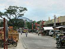
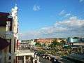 View of the city from the Bell Tower
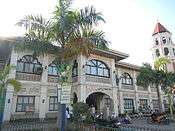 Eugenio Pérez Memorial Building, Museum
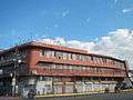 Kaluyagan Rural Bank and Palaris Colleges School (JT Baun Building)
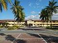 Pangasinan Provincial Hospital
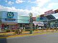
References
- ↑ "City". Quezon City, Philippines: Department of the Interior and Local Government. Retrieved 30 May 2013.
- ↑ "Province: Pangasinan". PSGC Interactive. Quezon City, Philippines: Philippine Statistics Authority. Retrieved 12 November 2016.
- 1 2 3 Census of Population (2015). "Region I (Ilocos Region)". Total Population by Province, City, Municipality and Barangay. PSA. Retrieved 20 June 2016.
- ↑ ": Cities and Municipalities Competitiveness Index". Makati, Philippines: National Competitiveness Council (Philippines). Missing or empty
|url=(help);|access-date=requires|url=(help) - ↑ "PSA Releases the 2012 Municipal and City Level Poverty Estimates". Quezon City, Philippines: Philippine Statistics Authority. Archived from the original on 28 January 2017. Retrieved 28 January 2017.
- ↑ http://www.saintdominicparish.org/history-of-san-carlos-city.html
- ↑ Census of Population and Housing (2010). "Region I (Ilocos Region)". Total Population by Province, City, Municipality and Barangay. NSO. Retrieved 29 June 2016.
- ↑ Censuses of Population (1903–2007). "Region I (Ilocos Region)". Table 1. Population Enumerated in Various Censuses by Province/Highly Urbanized City: 1903 to 2007. NSO.
- ↑ "Province of Pangasinan". Municipality Population Data. Local Water Utilities Administration Research Division. Retrieved 17 December 2016.
- ↑ "San Carlos, Pangasinan: Average Temperatures and Rainfall". World Weather Online. Retrieved 31 October 2015.
- ↑ Giant Mango Pie | San Carlos City, Pangasinan Archived 2013-02-01 at Archive.is
- ↑ Manila Bulletin
- ↑ http://www.abs-cbnnews.com/nation/regions/04/27/11/giant-mango-pie-aims-guinness-world-record
- ↑ BP: 400 sqm na mango pie, iniluto sa San Carlos City | Balita Pilipinas | GMA News Online
- ↑ Largest Mango Pie: Philippines sets world record
External links
| Wikivoyage has a travel guide for San Carlos (Pangasinan). |
| Wikimedia Commons has media related to San Carlos, Pangasinan. |
- City Profile at the National Competitiveness Council of the Philippines
- San Carlos at the Pangasinan Government Website
- Local Governance Performance Management System
- Philippine Standard Geographic Code
- Philippine Census Information
- Pangasinan.org : San Carlos Family and School Reunion Archives
- Saint Dominic Parish
Places adjacent to San Carlos, Pangasinan | ||||||||||
|---|---|---|---|---|---|---|---|---|---|---|
| ||||||||||
