Catarman, Northern Samar
| Catarman | ||
|---|---|---|
| Municipality | ||
| Municipality of Catarman | ||
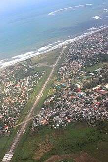
 Aerial view of Catarman | ||
| ||
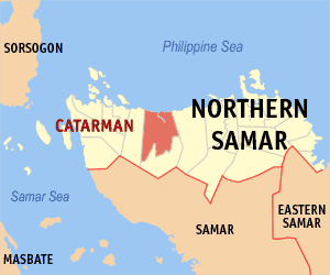 Map of Northern Samar with Catarman highlighted | ||
.svg.png) Catarman Location within the Philippines | ||
| Coordinates: 12°27′N 124°39′E / 12.45°N 124.65°ECoordinates: 12°27′N 124°39′E / 12.45°N 124.65°E | ||
| Country |
| |
| Region | Eastern Visayas (Region VIII) | |
| Province | Northern Samar | |
| District | 1st District | |
| Barangays | 55 (see Barangays) | |
| Government [1] | ||
| • Type | Sangguniang Bayan | |
| • Mayor | Francisco C. Rosales, Jr. | |
| • Electorate | 49,124 voters (2016) | |
| Area [2] | ||
| • Total | 464.43 km2 (179.32 sq mi) | |
| Population (2015 census)[3] | ||
| • Total | 94,037 | |
| • Density | 200/km2 (520/sq mi) | |
| Demonym(s) | Catarmanon | |
| Time zone | UTC+8 (PST) | |
| ZIP code | 5400 | |
| PSGC | 084805000 | |
| IDD : area code | +63 (0)55 | |
| Climate type | Tropical rainforest climate | |
| Income class | 1st municipal income class | |
| Revenue (₱) | 261,995,840.02 (2016) | |
| Native languages |
Waray Tagalog | |
| Website |
www | |

Catarman, officially the Municipality of Catarman, (Waray: Bungto san Catarman; Cebuano: Lungsod sa Catarman; Filipino: Bayan ng Catarman), is a 1st class municipality and capital of the province of Northern Samar, Philippines. According to the 2015 census, it has a population of 94,037 people.[3]
It is the largest municipality in terms of land area and population in the province. It is the commercial, educational, financial, political and government center of the province. It lies on the northern part of Samar Island, bounded to the east by Mondragon, to the west by Bobon, to the south by Lope de Vega, and to the north by the Philippine Sea.
Geography
On the Pacific coast are flat lowlands with the interior characterized by outlying low hills. Mount Puyao in Barangay Liberty is the highest peak in the area. The Catarman River, a major provincial river, divides the eastern and the western parts of the town. It is fed by the Paticua, Hibulwangan, Mahangna, Tura, and Danao creeks together with lesser prominent estuaries.
Barangays
The Municipality of Catarman is politically subdivided into 55 barangays, 17 of them in the poblacion.
- Acacia (pob.)
- Aguinaldo
- Airport Village (pob.)
- Bangkerohan
- Baybay (pob.)
- Bocsol
- Cabayhan
- Cag-abaca
- Cal-igang
- Calachuchi (pob.)
- Casoy (pob.)
- Cawayan
- Cervantes
- Cularima
- Daganas
- Dalakit (pob.)
- Doña Pulqueria
- Galutan
- Gebalagnan
- Gibulwangan
- Guba
- Hinatad
- Imelda
- Ipil-ipil (pob.)
- Jose Abad Santos (pob.)
- Jose P. Rizal (pob.)
- Lapu-lapu (pob.)
- Liberty
- Libjo
- Mabini
- Mabolo (pob.)
- Macagtas
- Malvar
- McKinley
- Molave (pob.)
- Narra (pob.)
- New Rizal
- Old Rizal
- Paticua
- Polangi
- Quezon
- Salvacion
- Sampaguita (pob.)
- San Julian
- San Pascual
- Santol (pob.)
- Somoge
- Talisay (pob.)
- Tinowaran
- Trangue
- UEP Zone I
- UEP Zone II
- UEP Zone III
- Washington
- Yakal (pob.)
Climate
| Climate data for Catarman, Northern Samar (1981–2010, extremes 1949–2012) | |||||||||||||
|---|---|---|---|---|---|---|---|---|---|---|---|---|---|
| Month | Jan | Feb | Mar | Apr | May | Jun | Jul | Aug | Sep | Oct | Nov | Dec | Year |
| Record high °C (°F) | 34.2 (93.6) |
34.0 (93.2) |
35.4 (95.7) |
37.2 (99) |
37.7 (99.9) |
38.0 (100.4) |
36.7 (98.1) |
37.1 (98.8) |
37.5 (99.5) |
35.5 (95.9) |
36.0 (96.8) |
34.3 (93.7) |
38.0 (100.4) |
| Average high °C (°F) | 29.3 (84.7) |
29.9 (85.8) |
30.8 (87.4) |
32.1 (89.8) |
33.2 (91.8) |
33.0 (91.4) |
32.4 (90.3) |
33.0 (91.4) |
32.6 (90.7) |
31.7 (89.1) |
30.6 (87.1) |
29.6 (85.3) |
31.5 (88.7) |
| Daily mean °C (°F) | 26.0 (78.8) |
26.1 (79) |
26.6 (79.9) |
27.6 (81.7) |
28.4 (83.1) |
28.5 (83.3) |
28.1 (82.6) |
28.5 (83.3) |
28.1 (82.6) |
27.6 (81.7) |
27.0 (80.6) |
26.3 (79.3) |
27.4 (81.3) |
| Average low °C (°F) | 22.6 (72.7) |
22.3 (72.1) |
22.4 (72.3) |
23.0 (73.4) |
23.7 (74.7) |
23.9 (75) |
23.8 (74.8) |
24.1 (75.4) |
23.7 (74.7) |
23.5 (74.3) |
23.3 (73.9) |
23.0 (73.4) |
23.3 (73.9) |
| Record low °C (°F) | 16.9 (62.4) |
17.2 (63) |
17.6 (63.7) |
19.0 (66.2) |
20.0 (68) |
20.0 (68) |
20.8 (69.4) |
20.6 (69.1) |
19.4 (66.9) |
19.9 (67.8) |
17.8 (64) |
18.2 (64.8) |
16.9 (62.4) |
| Average rainfall mm (inches) | 456.7 (17.98) |
291.9 (11.492) |
234.3 (9.224) |
143.9 (5.665) |
145.2 (5.717) |
195.3 (7.689) |
208.2 (8.197) |
173.6 (6.835) |
210.5 (8.287) |
338.4 (13.323) |
529.7 (20.854) |
628.2 (24.732) |
3,556 (140) |
| Average rainy days (≥ 0.1 mm) | 23 | 18 | 16 | 13 | 13 | 15 | 16 | 13 | 15 | 20 | 24 | 26 | 212 |
| Average relative humidity (%) | 88 | 86 | 85 | 84 | 83 | 83 | 85 | 82 | 84 | 86 | 88 | 88 | 85 |
| Source: PAGASA[4][5] | |||||||||||||
History


Before the coming of the Spaniards, Catarman (Calatman) or (Cataruman) was a settlement by the mouth of the river of the same name in the region called Ibabao. The Spanish Conquistadores freely applied the name Ibabao to the northern part of Samar island when it established its civil government. The similarities in the vocabularies and pronunciation of the dialects of these areas traces them to a common root as a people.
The town was one of the 13 villages and settlements and adopted as pueblos by the Spaniards in Samar Island and was one of the settlements in the northern parts of the island. The pueblo was named Calatman and was one of the pueblos in the Visayan islands, then collectively referred to as Islas de Pintados. Test Edit.
Conversion to Cityhood
In 2003, its application for cityhood was deterred after officials of the neighboring of towns Bobon and Mondragon opposed the planned Catarman City conglomeration, which was necessary to meet the criteria for the approval of its bid for cityhood. Another bill was filed converting the Municipality of Catarman into a component city of Northern Samar but is still pending with the Committee on Local Government in the House of Representatives since July 2010. The rise of establishments and banking institutions has swiftly came and filled the spaces of Catarman that paved the way for it to become competitive.
Demographics
| Population census of Catarman | ||
|---|---|---|
| Year | Pop. | ±% p.a. |
| 1903 | 9,994 | — |
| 1918 | 13,278 | +1.91% |
| 1939 | 21,007 | +2.21% |
| 1948 | 33,153 | +5.20% |
| 1960 | 39,434 | +1.46% |
| 1970 | 44,438 | +1.20% |
| 1975 | 53,267 | +3.70% |
| 1980 | 59,021 | +2.07% |
| 1990 | 50,965 | −1.46% |
| 1995 | 61,705 | +3.65% |
| 2000 | 67,671 | +2.00% |
| 2007 | 81,067 | +2.52% |
| 2010 | 84,833 | +1.67% |
| 2015 | 94,037 | +1.98% |
| Source: Philippine Statistics Authority[3] [6] [7] [8] | ||
Transportation

There is only one airline operating through the Catarman National Airport (IATA: CRM) coming from and going to Manila: PAL Express. Flights are frequently booked out well in advance and a one way ticket from Manila costs between PhP3,000 and PhP8,000 unless booked well in advance. Pedicabs, commonly known as "padyak" and tricycles are the means of transportation within the town, while multicabs, jeepneys, and vans are the means of transportation to neighboring and distant towns within the province. Several taxi and bus companies are also operating from the town going to Manila or Tacloban city and vice versa.
Education
Catarman is home to the University of Eastern Philippines, the first state university in the visayas and the largest university by student population and curriculum in Eastern Visayas. The University has satellite campuses in the province, one in Laoang and the other in Catubig (officially known the Pedro Rebadulla Memorial Campus), and has several extension programs offered across satellite campuses in the region.
Catarman is also an abode to the top performing schools in the region which already have a name in the National Level.
Other public and private schools (but not limited to):
Elementary:
- Catarman Chamber Elementary School
- Catarman I Central School
- Catarman II Central School
- Catarman III Central School
- Baybay Elementary School
- Catarman SpEd Center
- Cawayan Integrated School
- Colegio de San Lorenzo Ruiz de Manila (Elementary)
- Northern Samar Colleges (Elementary)
- University of Eastern Philippines Laboratory Elementary School
High school:
- University of Eastern Philippines Laboratory High School
- Colegio de San Lorenzo Ruiz de Manila (Highschool)
- Northern Samar Colleges (Highschool)
- Saint Michael Academy (Catarman)
- Catarman National High School
- Eastern Visayas High School (High School)
Tertiary/College/Vocational:
- University of Eastern Philippines
- Eastern Visayas Central Colleges
- Colegio De San Lorenzo Ruiz De Manila
- Technical Education and Skills Development Authority (TESDA)
- Global School for Technological Studies
- East Pacific Computer College
- Northern Samar Colleges
- Lyceum of the Visayas
References
- ↑ "Municipality". Quezon City, Philippines: Department of the Interior and Local Government. Retrieved 31 May 2013.
- ↑ "Province: Northern Samar". PSGC Interactive. Quezon City, Philippines: Philippine Statistics Authority. Retrieved 12 November 2016.
- 1 2 3 Census of Population (2015). "Region VIII (Eastern Visayas)". Total Population by Province, City, Municipality and Barangay. PSA. Retrieved 20 June 2016.
- ↑ "Catarman, Northern Samar Climatological Normal Values". Philippine Atmospheric, Geophysical and Astronomical Services Administration. Archived from the original on 11 October 2018. Retrieved 11 October 2018.
- ↑ "Catarman, Northern Samar Climatological Extremes". Philippine Atmospheric, Geophysical and Astronomical Services Administration. Archived from the original on 11 October 2018. Retrieved 11 October 2018.
- ↑ Census of Population and Housing (2010). "Region VIII (Eastern Visayas)". Total Population by Province, City, Municipality and Barangay. NSO. Retrieved 29 June 2016.
- ↑ Censuses of Population (1903–2007). "Region VIII (Eastern Visayas)". Table 1. Population Enumerated in Various Censuses by Province/Highly Urbanized City: 1903 to 2007. NSO.
- ↑ "Province of Northern Samar". Municipality Population Data. Local Water Utilities Administration Research Division. Retrieved 17 December 2016.
External links
| Wikimedia Commons has media related to Catarman, Northern Samar. |
| Wikivoyage has a travel guide for Catarman. |
- Philippine Standard Geographic Code
- Philippine Census Information
- Local Governance Performance Management System
- Rizal Pié Artesian
Places adjacent to Catarman, Northern Samar | ||||||||||
|---|---|---|---|---|---|---|---|---|---|---|
| ||||||||||
Catarman (capital) | |
| Municipalities | |