Muñoz, Nueva Ecija
| Muñoz | ||
|---|---|---|
| Component City | ||
| Science City of Muñoz | ||
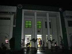 City Hall | ||
| ||
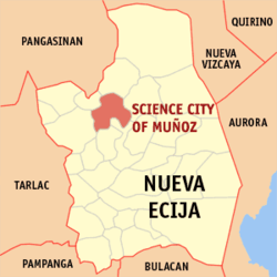 Map of Nueva Ecija with Muñoz highlighted | ||
.svg.png) Muñoz Location within the Philippines | ||
| Coordinates: 15°43′N 120°54′E / 15.72°N 120.9°ECoordinates: 15°43′N 120°54′E / 15.72°N 120.9°E | ||
| Country |
| |
| Region | Central Luzon (Region III) | |
| Province | Nueva Ecija | |
| District | 2nd District | |
| Founded | 1913 | |
| Cityhood | December 9, 2000 | |
| Barangays | 37 (see Barangays) | |
| Government [1] | ||
| • Type | Sangguniang Panlungsod | |
| • Mayor | Nestor Lazaro Alvarez | |
| • Electorate | 47,690 voters (2016) | |
| Area [2] | ||
| • Total | 163.05 km2 (62.95 sq mi) | |
| Population (2015 census)[3] | ||
| • Total | 81,483 | |
| • Density | 500/km2 (1,300/sq mi) | |
| Time zone | UTC+8 (PST) | |
| ZIP code | 3119, 3120 | |
| PSGC | 034917000 | |
| IDD : area code | +63 (0)44 | |
| Climate type | Tropical monsoon climate | |
| Income class | 4th city income class | |
| Revenue (₱) | 426,116,290.51 (2016) | |
| Native languages |
Ilocano Tagalog | |
| Website |
www | |

Muñoz, officially the Science City of Muñoz, is a 4th class city in the province of Nueva Ecija, Philippines. According to the 2015 census, it has a population of 81,483 people.[3]
Situated 151 kilometres (94 mi) north of the capital Manila and due to its rich topography and tropical climate, it is now home to agricultural research and technology centers, committed to the production of information and technological breakthroughs to promote rural development, productivity and food security.
From its lowly origins as “Sitio Papaya”, it was renamed as Muñoz in 1886 in honor of Spanish Governor Don Francisco Muñoz. It was in 1913, under Executive Order No. 72, when Muñoz was declared as a new and independent municipality.
Barangays
Muñoz is politically subdivided into 37 barangays:
- Bagong Sikat
- Balante
- Bantug
- Bical
- Cabisuculan
- Calabalabaan
- Calisitan
- Catalanacan
- Curva
- Franza
- Gabaldon
- Labney
- Licaong
- Linglingay
- Mangandingay
- Magtanggol
- Maligaya
- Mapangpang
- Maragol
- Matingkis
- Naglabrahan
- Palusapis
- Pandalla
- Poblacion East
- Poblacion North
- Poblacion South
- Poblacion West
- Rang-ayan
- Rizal
- San Andres
- San Antonio
- San Felipe
- Sapang Cauayan
- Villa Isla
- Villa Nati
- Villa Santos
- Villa Cuizon
History
From Sitio to Barrio
In 1886, Papaya was changed into 'Muñoz' to honor Don Francisco Muñoz, the province’s alcalde mayor, and the community’s first appointed gobernadorcillo. Muñoz was annexed as a barrio of San Juan de Guimba municipality. Settlers trickled in from Bulacan and the Ilocos Region. In 1911, Factoria (now San Isidro town), the provincial capital, was totally flooded. Muñoz was then considered a possible new capital of the province.
At about the same time, the people of Barrios Muñoz and San Antonio, also in San Juan de Guimba town, and Palusapis in Sto. Domingo municipality, together with Sitios Kabisukulan, Rang-ayan, Mataas na Lupa, Siniguelas, Purok Agrikultura, and Pulong Maragul in Talavera town, were organizing themselves to be separated from their three respective municipalities to become a new independent municipality. They were prepared to construct a municipal hall and a school building for the emerging town.
From Barrio to town and Science City
On the recommendation of the Provincial Board of Nueva Ecija, then headed by Governor Isauro Gabaldon, and with approval of then Acting Governor General Newton Gilbert, the organized barrios and sitios were granted independence as a regular municipality on January 10, 1913 under the name of Muñoz. The seat of the fledgling municipal government was positioned in erstwhile Barrio Muñoz. The municipality of Muñoz was born and steadily grew to become an agricultural Science City in the making.
A municipal hall, a church, and a small public market were erected in Lumang Bayan (now Poblacion North). A road linking the young Muñoz town with the national highway from Barangay Bacal, Talavera was constructed. In World War II, Muñoz was the last stronghold of the Japanese Imperial Army; the Allied liberation in Muñoz by the joint United States and Philippine Commonwealth forces offensive razed the town to the ground in a matter of days.
In 2000, after achieving cityhood status, universities and scientific research institutes sprung up. The local government used and, after ratified, adopted the Science city status.
Demographics
| Population census of Muñoz | ||||||||||||||||||||||||||||||||||||||||||||||
|---|---|---|---|---|---|---|---|---|---|---|---|---|---|---|---|---|---|---|---|---|---|---|---|---|---|---|---|---|---|---|---|---|---|---|---|---|---|---|---|---|---|---|---|---|---|---|
|
| |||||||||||||||||||||||||||||||||||||||||||||
| Source: Philippine Statistics Authority[3][4][5][6] | ||||||||||||||||||||||||||||||||||||||||||||||
Religion
Churches:
- Sacred Heart of Jesus Shrine
- San Sebastian parish Church
- Christ the Worker Parish Church
- Iglesia ni Cristo
- Christian Churches
Economy
There are many new establishments in Munoz in the past few years. Notable are Friendship Supermarket, Inc (FSi), and the Villa-Mendoza Training Institute, both are now major landmarks on the city.
With a bustling market center with rice trading as a major economic activity, it has transformed into its present status as a Science City by virtue of Republic Act 8977 on December 9, 2000. Being a science city, Muñoz was acknowledged as one of the members of League of Cities of the Philippines and became a pilot city of achieving the United Nation’s Millennium Development Goals.
Research and development centers:
- The Philippine Rice Research Institute (PhilRice) (formerly the Maligaya Rice Research and Training Center (MRRTC)) is found in Muñoz
- Central Office of the Philippine Carabao Center (PCC).
- National Freshwater and Fisheries Training and Research Center (NFFTRC)
- The main offices of the Bureau of Postharvest Research and Extension (BPRE)
- Bureau of Fisheries and Aquatic Resources (BFAR-NFFTC) are also based in Muñoz.
Transportation
As with most towns in Central Luzon, inter-city transport is through the Pan-Philippine Highway (also known as Maharlika Highway/ Asian Highway 26), the country's principal transport backbone. The principal mode of transport is through Jeepneys with fixed routes, or through tricycles, whom you need to tell where to go.
Buses from Cagayan Valley to Manila and vice versa stops here.
From Manila, you can ride a public bus going to San Jose City, Nueva Ecija or Take the North Luzon Expressway (NLEX) and Subic-Clark-Tarlac Expressway (SCTEX) and take La Paz Exit. And continue until reaching the city.
Land use
| Land use | Hectares |
|---|---|
| Agricultural | 9,819 |
| Residential | 2,847 |
| Commercial and industrial | 784 |
| Institutional | 740 |
| Forest hills and pasture | 1,215 |
| Roads | 246 |
| Water bodies | 516 |
| Open spaces | 138 |
| Total | 16,305 |
Education
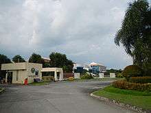
- Central Luzon State University: is a state university on a 658-hectare campus in Science City of Muñoz, Nueva Ecija, Philippines. It is the lead agency of the Muñoz Science Community and the seat of the Regional Research and Development Center in Central Luzon. To date, CLSU is one of the premier institutions of agriculture in Southeast Asia and known for its breakthrough researches in aquatic culture (pioneer in the sex reversal of tilapia), ruminant, crops, orchard, and water management researches. https://clsu.edu.ph/
References
- ↑ "City". Quezon City, Philippines: Department of the Interior and Local Government. Retrieved 30 May 2013.
- ↑ "Province: Nueva Ecija". PSGC Interactive. Quezon City, Philippines: Philippine Statistics Authority. Retrieved 12 November 2016.
- 1 2 3 Census of Population (2015). "Region III (Central Luzon)". Total Population by Province, City, Municipality and Barangay. PSA. Retrieved 20 June 2016.
- ↑ Census of Population and Housing (2010). "Region III (Central Luzon)". Total Population by Province, City, Municipality and Barangay. NSO. Retrieved 29 June 2016.
- ↑ Censuses of Population (1903–2007). "Region III (Central Luzon)". Table 1. Population Enumerated in Various Censuses by Province/Highly Urbanized City: 1903 to 2007. NSO.
- ↑ "Province of Nueva Ecija". Municipality Population Data. Local Water Utilities Administration Research Division. Retrieved 17 December 2016.
External links
| Wikivoyage has a travel guide for Muñoz, Nueva Ecija. |
| Wikimedia Commons has media related to Muñoz, Nueva Ecija. |
- Science City Of Muñoz Official Website
- Philippine Standard Geographic Code
- Philippine Census Information
- Local Governance Performance Management System
- Inquirer.net, Carabao may be key to biofuel, says scientist
Places adjacent to Muñoz, Nueva Ecija | |
|---|---|