La Trinidad, Benguet
| La Trinidad | ||
|---|---|---|
| Municipality | ||
| Municipality of La Trinidad | ||
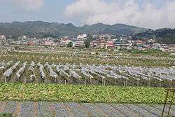 La Trinidad strawberry fields | ||
| ||
| Nickname(s): | ||
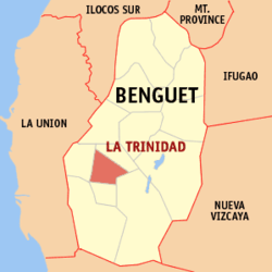 Map of Benguet with La Trinidad highlighted | ||
.svg.png) La Trinidad Location within the Philippines | ||
| Coordinates: 16°28′N 120°35′E / 16.46°N 120.59°ECoordinates: 16°28′N 120°35′E / 16.46°N 120.59°E | ||
| Country |
| |
| Region | Cordillera Administrative Region (CAR) | |
| Province | Benguet | |
| District | Lone District | |
| Converted to municipality | 1950 | |
| Barangays | 16 (see Barangays) | |
| Government [3] | ||
| • Type | Sangguniang Bayan | |
| • Mayor | Romeo Salda | |
| • Vice Mayor | Joey Jovencio Marrero | |
| • Electorate | 39,607 voters (2016) | |
| Area [4] | ||
| • Total | 70.04 km2 (27.04 sq mi) | |
| Population (2015 census)[5] | ||
| • Total | 129,133 | |
| • Density | 1,800/km2 (4,800/sq mi) | |
| Time zone | UTC+8 (PST) | |
| ZIP code | 2601 | |
| PSGC | 141110000 | |
| IDD : area code | +63 (0)74 | |
| Climate | Am | |
| Income class | 1st municipal income class | |
| Revenue (₱) | 314,459,930.16 (2016) | |
| Native languages |
Kankanaey language Ibaloi Tagalog | |
| Website |
www | |

La Trinidad, officially the Municipality of La Trinidad (Ilokano: Ili ti La Trinidad; Filipino: Bayan ng La Trinidad), is a 1st class municipality and capital of the province of Benguet, Philippines. According to the 2015 census, it has a population of 129,133 people.[5]
The municipality is known for its strawberry and vegetable plantations earning the title "Strawberry Fields of the Philippines" [1][6]
History
Spanish period
The valley encompassing La Trinidad was originally called "Benguet", a thriving community of Ibaloi migrants from Tinek.[1] Natives traded local products, which included gold, with nearby lowland towns that had Dominican and Augustinian missions established. About 1616, the procurator general of Manila, Hemando de 1os Rios Coronel became interested in the mountain gold and proposed to the Spanish King to expedite its search. He wrote both Alonso Fajardo, the Governor of Manila, and the Archbishop of Manila on December 1618 that it was the solution to both the abandoned missions as well as the depleted colonial treasury. Fajardo requested feedback from the religious orders on this matter; whether waging a war against the Igorots was just. Only the Jesuits objected with the war, preferring only that their "mines be occupied in the name of his Majesty".[7]
In 1620, Fajardo sent the first expedition under Captain Garcia Aldana y Cabrera, Governor of Pangasinan. Aldana and his men took the route from Aringay, crossing the Naguilian River to Duplas (La Union), then followed the Bornotan (Santo Rosario) River eventually reaching Takdian. Upon arriving at the mining community of Bua, the men found only a recently burned village, suggesting the natives fled with nothing for them to plunder. Aldana examined the Antamok mines and was able to gather some gold.[7]
A second expedition was sent in 1623 under the command of Sergeant Major Antonio Carreño de Valdes. Carreño was able to repel some Igorot assaults, builing two forts; 'Fort Santiago' overlooking the present Santo Nino mines, and 'Fort del Rosario' in the Antamok-Itogon area. The Igorots submitted to Spanish authorities only to strike back when the rainy season made it difficult to send manpower and new supplies, prompting the Spaniards to retreat.[7]
Finally, in 1624, Fajardo sent Captain Alonso Martin Quirante, a master of strategy, logistics and tactics. In February of that year, Quirante took off with a huge expedition of 1,903 soldiers, carpenters, miners, smiths, slaves, clerks and some requisite clergy. He divided his large force into three; the first to clear the road, the second to follow, and the third with rations and arms. This ensured they would reach the mining area after clearing out an Igorot fort along the way. Quirante was able to reach the mining areas, and discovered about two hundred abandoned houses, implying the locals fled beforehand. He rebuilt Fort Santiago, and examined five mines; four of which showed signs of having been abandoned by the Igorots: Arisey Bugayona, Baranaban, Antamog, and Conog. The fifth mine called Galan was still operational. Quirante ordered baskets of ore gathered from each mine, labeled and ready for assaying. The results showed no evidence of deposits rich enough to yield attractive profit, prompting Quirante to return to Manila with 400 baskets of ore to be sent to Mexico for further assaying.[7]
Meanwhile, the Royal Audiencia had become concerned at the expense of the project which had already cost 33,982 pesos. Don Geronimo Silva took over the government, convening the council to decide on the issue. The Royal Audiencia decided to abandon the project because of mounting expenses, loss of life and the continued hostility of the Igorots and their land.[7]
In 1829, another expedition was sent to Benguet under Guillermo Galvey.[1]
Although the District of Benguet was established in La Trinidad by 1846, it was only in April 21, 1874, under Commandant Manuel Scheidnagel, that "Valle de Benguet" was renamed "Valle de La Trinidad" (La Trinidad Valley). Despite popular acceptance that it was named as "a fitting tribute to Galvey’s wife - Doña Trinidad de Galvey" – recent research has revealed that credit should have probably gone to Scheidnagel, having been inspired by the three prominent adjacent hills (in effect, forming a Trinity: a religious icon of the Christian campaign) overlooking the Poblacion church, where the seat of government, the Cabecera, was established.[8]
Together with 40 other smaller surrounding rancherías, La Trinidad was placed under the jurisdiction of the newly established Benguet commandancia politico-militar in 1846[9][10] and was established as its administrative headquarters during the Spanish Conquest of the Philippines.[1][11][12]
American period
During the Philippine Revolution in July 1899, Filipino revolutionary forces under Pedro Paterno liberated La Trinidad from the Spaniards and took over the government, proclaiming Benguet as a province of the new Philippine Republic, with La Trinidad as its capital.[13][1]
In 1900, the American colonizers arrived, and La Trinidad was established as one of the 19 townships under Benguet province, upon the issuance of Act No. 48.[11][14] For a brief period, Baguio became the capital of Benguet when appointed Benguet province civil governor H.P. Whitmarsh moved the seat of government from La Trinidad to Baguio in 1901. La Trinidad was made the provincial capital again in 1909, after the Baguio township was abolished and converted into a chartered city.[1]
Second World War
In 1942, Japanese soldiers occupied La Trinidad, Benguet.
On May 3, 1945, The Filipino soldiers of the 2nd, 12th, 13th, 15th and 16th Infantry Division of the Philippine Commonwealth Army, 1st Constabulary Regiment of the Philippine Constabulary, and the 66th Infantry Regiment of the United States Armed Forces in the Philippines - Northern Luzon or USAFIP-NL liberated La Trinidad.[1]
Modern history
La Trinidad was transformed into a full-fledged town from its former status as municipal district by virtue of Republic Act No. 531, approved June 16, 1950.[15]

On June 23, 2016, La Trinidad was highlighted in the media when the first and largest community artwork in the Philippines, the STOBOSA Hillside Homes Artwork was unveiled, featuring hillside houses within the sitios of Stonehill, Botiwtiw and Sadjap of Barangay Balili painted with sunflower and abstract designs.[16][17]
Today, people often hear about the town's push for cityhood. The town had long surpassed the requirements for annual income, but could not comply with either of the minimum population or land area requirements of at least 150,000 inhabitants or a contiguous territory of 100 square kilometers, as mandated by the Local Government Code.[18][19][20]
Geography

La Trinidad is located at 16°28′N 120°35′E / 16.46°N 120.59°E, at the central portion of Benguet. It is bounded by Tublay on the north-east, Sablan on the west, Baguio City on the south, Itogon on the southeast, and Tuba on the south-west.
According to the Philippine Statistics Authority, the municipality has a land area of 70.04 square kilometres (27.04 sq mi) [4] constituting 2.53% of the 2,769.08-square-kilometre- (1,069.15 sq mi) total area of Benguet.
The terrain is generally mountainous with springs, rivers and creeks. The town has a valley which encompasses several barangays. The valley floor elevation is at 1,300 metres (4,300 ft) above sea level. Elevation ranges from 500 to 1,700 metres (1,600 to 5,600 ft) above sea level.
Balili River is the municipality's main water drainage which carries upstream water from Sagudin River in Baguio City.[21] The river merges with another upstream river in Tuel upon reaching the La Trinidad-Tublay-Sablan tri-point.
Climate
.jpeg)
La Trinidad belongs under the Type I climate by the Coronas System of classification with distinct wet and dry seasons. The dry season is from November to April while the wet season occurs during the rest of the year. The climate is cool with temperatures ranging from 11.7 °C (53.1 °F) during the month of December at its coldest and 23.2 °C (73.8 °F) at its warmest during the months of March, April and May. The average daily temperature is 18.55 °C (65.39 °F). Wind velocity is 1.43. During the rainiest month of August, the rainfall average is 850.70 millimetres (33.492 in).
| Climate data for La Trinidad | |||||||||||||
|---|---|---|---|---|---|---|---|---|---|---|---|---|---|
| Month | Jan | Feb | Mar | Apr | May | Jun | Jul | Aug | Sep | Oct | Nov | Dec | Year |
| Average high °C (°F) | 18.4 (65.1) |
18.9 (66) |
20.1 (68.2) |
21.2 (70.2) |
21.3 (70.3) |
20.7 (69.3) |
20.0 (68) |
19.7 (67.5) |
20.1 (68.2) |
20.2 (68.4) |
19.8 (67.6) |
19.2 (66.6) |
20 (68) |
| Average low °C (°F) | 14.0 (57.2) |
14.1 (57.4) |
15.3 (59.5) |
16.6 (61.9) |
17.3 (63.1) |
17.2 (63) |
16.8 (62.2) |
16.8 (62.2) |
16.8 (62.2) |
16.5 (61.7) |
15.9 (60.6) |
15.1 (59.2) |
16 (60.9) |
| Average rainfall mm (inches) | 22.8 (0.898) |
26.3 (1.035) |
54.8 (2.157) |
66.1 (2.602) |
313.1 (12.327) |
340.2 (13.394) |
640.7 (25.224) |
748.1 (29.453) |
601.3 (23.673) |
306.4 (12.063) |
131.2 (5.165) |
42.1 (1.657) |
3,293.1 (129.648) |
| Average rainy days | 5 | 5 | 6 | 10 | 21 | 22 | 26 | 26 | 25 | 18 | 11 | 6 | 181 |
| Source #1: Climate-data.org (for average temperatures)[22] | |||||||||||||
| Source #2: World Weather Online (for average rainfall and rainy days)[23] | |||||||||||||
Barangays
La Trinidad is politically subdivided into 16 barangays.[24], with 11 classified as urban and 5 as rural.[24] As of 2015, the most populous is Pico with 23,282 people, while Bineng, with 1,624 people, has the least.[5] Wangal is the largest in terms of land area,[25] while Cruz is the smallest.[26] Balili was the most densely populated, and Bineng was the least. Bineng has the most number of sitios, while Betag has the least with only 4.
| |||||||||||||||||||||||||||||||||||||||||||||||||||||||||||||||||||||||||||||||||||||||||||||||||||||||||||||||||||||||||||||||||||||||||||||||||||||||||||||||||||||||||||||||||||||||||||||||||||||||||||||||
Demographics
| Population census of La Trinidad | ||
|---|---|---|
| Year | Pop. | ±% p.a. |
| 1903 | 267 | — |
| 1918 | 3,013 | +17.53% |
| 1939 | 6,554 | +3.77% |
| 1948 | 7,994 | +2.23% |
| 1960 | 12,415 | +3.74% |
| 1970 | 18,551 | +4.09% |
| 1975 | 22,732 | +4.16% |
| 1980 | 28,713 | +4.78% |
| 1990 | 48,252 | +5.33% |
| 1995 | 63,089 | +5.15% |
| 2000 | 67,963 | +1.61% |
| 2007 | 97,810 | +5.15% |
| 2010 | 107,188 | +3.39% |
| 2015 | 129,133 | +3.61% |
| Source: Philippine Statistics Authority[5][27][42][43] | ||
In the 2015 census, La Trinidad had a population of 129,133.[5] The population density was 1,800 inhabitants per square kilometre (4,700/sq mi).
Economy
.jpg)
La Trinidad supplies most of the Philippines' strawberries[44] and cut flowers which include roses.[45][46][47] The La Trinidad Vegetable Trading Post is visited by wholesalers and traders of vegetables from other provinces.[48] The presence of the Benguet State University in the municipality serves as a boost to agricultural research and development in the region.[49]
The town landed on the Guinness Book of World Records for baking the world's largest strawberry shortcake, at 21,213.40 pounds (9,622.24 kg), at the La Trinidad Strawberry Festival on March 20, 2004.[50]
Its proximity to the city of Baguio attracts tourists, primarily to the strawberry fields in the valley, and lesser to the Benguet Provincial Capitol and the Rose Gardens of barangay Bahong.[2]
Education
La Trinidad, aside from the adjacent city of Baguio, is the center of higher education in Benguet province.[51]
Public schools
As of 2014, La Trinidad has 23 public elementary schools and 7 public secondary schools.[52][53][54]
The main campus of the Benguet State University, the first university in the province, is located in the municipality.
|
|
Private schools
- BVS Colleges
- Cordillera Career Development College
- King's College of the Philippines
- Northskills Polytechnic College
- Philippine Nazarene College
- Rainbow Mission International Academy
- San Jose School La Trinidad
- Star Colleges
- H.O.P.E. Christian Academy, Inc.
Notable people
La Trinidad is the burial place of:
- Deodato Arellano (1844–1899), a Filipino patriot and one of the founders of the Katipunan.
Sister city
Local
International


References
- 1 2 3 4 5 6 7 8 "Municipality of La Trinidad, Benguet". DILG-CAR. Archived from the original on 21 January 2016. Retrieved 18 September 2014.
- 1 2 Lago, Amanda (9 April 2012). "Benguet roses now a summer attraction". GMA News. Archived from the original on 4 March 2016. Retrieved 6 October 2014.
- ↑ "Municipality". Quezon City, Philippines: Department of the Interior and Local Government. Retrieved 31 May 2013.
- 1 2 "Province: Benguet". PSGC Interactive. Quezon City, Philippines: Philippine Statistics Authority. Retrieved 12 November 2016.
- 1 2 3 4 5 6 Census of Population (2015). "Cordillera Administrative Region (CAR)". Total Population by Province, City, Municipality and Barangay. PSA. Retrieved 20 June 2016.
- ↑ "Cordillera Autonomous Region". It's More Fun in the Philippines. Archived from the original on 9 May 2013. Retrieved 18 September 2014.
- 1 2 3 4 5 Habana, Olivia M. (2000). "Gold Mining in Benguet to 1898" (PDF). Philippine Studies. Ateneo de Manila University • Loyola Heights, Quezon City • 1108 Philippines. 48: 471–475. Retrieved 13 October 2018.
- ↑ Olsim, Valred E. (12 Jun 2017). "Olsim: La Trinidad at a glimpse". Sun.Star Philippines. Retrieved 28 September 2018.
- ↑ Lancion, Jr., Conrado M.; de Guzman, Rey (cartography) (1995). "The Provinces". Fast Facts about Philippine Provinces (The 2000 Millenium ed.). Makati, Metro Manila: Tahanan Books. p. 38. ISBN 971-630-037-9. Retrieved 16 January 2015.
- ↑ "History of Takdian (La Trinidad)". Province of Benguet (official website). Archived from the original on 14 October 2014. Retrieved 6 October 2014.
- 1 2 "Facts & Figures: Benguet Province". Philippine Statistics Authority - National Statistical Coordination Board - Cordillera Administrative Region. NSCB. 23 April 2012. Archived from the original on 28 February 2016. Retrieved 6 October 2014.
- ↑ "Profile of La Trinidad: LA TRINIDAD THROUGH THE YEARS". Archived from the original on 24 September 2014. Retrieved 16 September 2014.
- ↑ Sanidad, Pablito. "Which Baguio Centennial?" (99th Baguio Charter Day Anniversary Issue). Baguio Midland Courier. Retrieved 21 February 2016.
- ↑ "History: Benguet Province". Province of Benguet (official website). Archived from the original on 19 October 2014. Retrieved 9 October 2014.
- ↑ "Republic Act No. 531: An Act to Convert the Municipal District of La Trinidad, Subprovince of Benguet, Mountain Province, into a Regular Municipality to be Known as the Municipality of La Trinidad". PhilippineLaw.info. Archived from the original on 6 April 2012. Retrieved 2011-04-09.
- ↑ "La Trinidad residents create first, biggest community artwork in the Philippines". The Philippine Star. 24 June 2016. Archived from the original on 25 June 2016. Retrieved 30 October 2016.
- ↑ Lapniten, Karl (23 June 2016). "Artists turn Benguet hillside homes into mural". CNN Philippines. Archived from the original on 28 June 2016. Retrieved 30 October 2016.
- ↑ Membrere, Elamae (21 Sep 2016). "Cityhood beacons for La Trinidad". Sun.Star Philippines. Retrieved 28 September 2018.
- ↑ Pasagoy, Mark Victor (7 Sep 2016). "Dads divided in La Trinidad cityhood". Sun.Star Philippines. Retrieved 28 September 2018.
- ↑ Palangchao, Harley F. (19 Jun 2016). "Cityhood bid for La Trinidad to be refilled in 17th Congress". Baguio Midland Courier. Retrieved 28 September 2018.
- ↑ Susan Aro (11 October 2011). "Balili River wanting for clean, safe waters". Sun.Star Baguio. Sun.Star Baguio. Retrieved 16 September 2014.
- ↑ "Climate: La Trinidad". Climate-data.org. Retrieved 19 December 2016.
- ↑ "La Trinidad, Benguet Monthly Climate Average, Philippines". World Weather Online. Retrieved 19 December 2016.
- 1 2 3 4 "Municipal: La Trinidad, Benguet". PSGC Interactive. Quezon City, Philippines: Philippine Statistics Authority. Retrieved 8 January 2016.
- 1 2 3 4 "Barangay Wangal". Municipality of La Trinidad. 2015. Archived from the original (web page and PDF) on 31 October 2015. Retrieved 1 November 2015.
- 1 2 3 4 5 "Barangay Cruz" (web page and PDF). Municipality of La Trinidad. 2015. Retrieved 1 November 2015.
- 1 2 Census of Population and Housing (2010). "Cordillera Administrative Region (CAR)". Total Population by Province, City, Municipality and Barangay. NSO. Retrieved 29 June 2016.
- 1 2 3 4 "Barangay Alapang" (web page and PDF). Municipality of La Trinidad. 2015. Retrieved 1 November 2015.
- 1 2 3 4 "Barangay Alno" (web page and PDF). Municipality of La Trinidad. 2015. Retrieved 1 November 2015.
- 1 2 3 4 "Barangay Ambiong" (web page and PDF). Municipality of La Trinidad. 2015. Retrieved 1 November 2015.
- 1 2 3 4 "Barangay Bahong" (web page and PDF). Municipality of La Trinidad. 2015. Retrieved 1 November 2015.
- 1 2 3 4 "Barangay Balili" (web page and PDF). Municipality of La Trinidad. 2015. Retrieved 1 November 2015.
- 1 2 3 "Barangay Beckel" (web page and PDF). Municipality of La Trinidad. 2015. Retrieved 1 November 2015.
- 1 2 3 4 "Barangay Bineng" (web page and PDF). Municipality of La Trinidad. 2015. Retrieved 1 November 2015.
- 1 2 3 4 "Barangay Betag" (web page and PDF). Municipality of La Trinidad. 2015. Retrieved 1 November 2015.
- 1 2 3 4 "Barangay Lubas" (web page and PDF). Municipality of La Trinidad. 2015. Retrieved 1 November 2015.
- 1 2 3 "Barangay Pico" (web page and PDF). Municipality of La Trinidad. 2015. Retrieved 1 November 2015.
- 1 2 3 4 "Barangay Poblacion" (web page and PDF). Municipality of La Trinidad. 2015. Retrieved 1 November 2015.
- 1 2 3 "Barangay Puguis" (web page and PDF). Municipality of La Trinidad. 2015. Retrieved 1 November 2015.
- 1 2 3 4 "Barangay Shilan" (web page and PDF). Municipality of La Trinidad. 2015. Retrieved 1 November 2015.
- 1 2 3 4 "Barangay Tawang" (web page and PDF). Municipality of La Trinidad. 2015. Retrieved 1 November 2015.
- ↑ Censuses of Population (1903–2007). "Cordillera Administrative Region (CAR)". Table 1. Population Enumerated in Various Censuses by Province/Highly Urbanized City: 1903 to 2007. NSO.
- ↑ "Province of Benguet". Municipality Population Data. Local Water Utilities Administration Research Division. Retrieved 17 December 2016.
- ↑ Caluza, Desiree (27 April 2013). "What is life without strawberry in La Trinidad Valley?". Philippine Daily Inquirer. Archived from the original on 31 October 2016. Retrieved 5 January 2015.
- ↑ Catajan, Maria Elena (13 February 2014). "Benguet blooms in focus". Sun.Star Baguio. Archived from the original on 10 October 2014. Retrieved 6 October 2014.
- ↑ Rillorta, Paul (22 March 2012). "City supports La Trinidad strawberry festival –mayor". Official website of the City Government of Baguio. Archived from the original on 3 March 2016. Retrieved 5 January 2015.
- ↑ Agreda, JM (13 March 2014). "La Trinidad hopes strawberries will draw tourists". 9News Philippines. Retrieved 6 October 2014.
- ↑ Obnial, Angela (December 2005). "La Trinidad veggie trading post revisited". Bureau of Agricultural Research Chronicle. Archived from the original on 9 October 2014. Retrieved 6 October 2014.
- ↑ Dumlao, Artemio (11 July 2013). "Benguet State U starts developing organic agri program". The Philippine Star. Retrieved 6 October 2014.
- ↑ "Largest fruit shortcake". Guinness World Records. Archived from the original on 11 August 2016. Retrieved 6 January 2015.
- ↑ "La Trinidad Now Rivals Baguio as Educational Center". Joseph. Goshen Land. 11 June 2015. Archived from the original on 8 October 2016. Retrieved 22 July 2016.
- ↑ "Masterlist of Public Elementary Schools for the School year 2012- 2013" (XLSX). Department of Education (Philippines), July 15, 2013. Retrieved 28 December 2014.
- 1 2 "Masterlist of Secondary Schools (School Year 2013- 2014)". Department of Education (Philippines), July 4, 2013. Archived from the original (XLSX) on 1 July 2014. Retrieved 20 November 2014.
- 1 2 "Masterlist of Public Schools SY 2013-2014" (XLSX). Department of Education (Philippines), 22 October 2014. Retrieved 28 December 2014.
- ↑ Catajan, Maria Elena (28 October 2013). "La Trinidad helps sister city Danao, Bohol". Baguio, Philippines: Sun.Star Publishing Inc. Retrieved 4 February 2015.
- 1 2 3 "List of Sister City Affiliations with Japan (by country)". Clair Singapore.
- ↑ Golosino, Shena (21 Mar 2017). "La Trinidad-Korea inks sisterhood ties". SunStar Philippines. SunStar Publishing Inc. Retrieved 12 October 2018.
- ↑ Cachero, Carol (28 Nov 2014). "La Trinidad, Tamuning sign sisterhood agreement". SunStar Philippines. SunStar Publishing Inc. Retrieved 12 October 2018.
- ↑ "MAYORS OF LA TRINIDAD AND SABLAN IN BENGUET PROVINCE CALL ON PHL CONSUL GENERAL DURING THEIR VISIT TO GUAM". Department of Foreign Affairs. 28 January 2016. Retrieved 12 October 2018.
La Trinidad and Sablan have sister-city agreements with Tamuning and Agat villages, respectively.
- ↑ Cachero, Carol (28 Nov 2014). "Valley links with Laemrung". SunStar Philippines. SunStar Publishing Inc. Retrieved 12 October 2018.
External links
- Municipality of La Trinidad (official website)


