Cotabato City
| Cotabato Kutabato | ||
|---|---|---|
| Independent Component City | ||
| City of Cotabato | ||
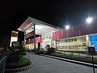
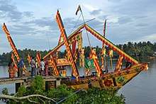
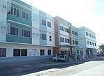
  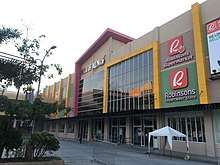 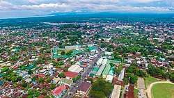 Rio Grande De Mindanao in Cotabato City; City Hall of Cotabato; Mall of Alnor (Robinsons Town Center); Eagle eye view of Cotabato City | ||
| ||
|
Nickname(s): “City of Cultural Charms” “City of Rivers and Creeks” “Stone Fortress of Mindanao” “The Historical City of Cotabato” “Halal Capital of the Philippines” | ||
| Motto(s): Sigay ka Cotabato! (Shine Cotabato!) | ||
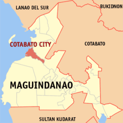 Map of Maguindanao highlighting Cotabato City | ||
.svg.png) Cotabato Location within the Philippines | ||
| Coordinates: 7°13′N 124°15′E / 7.22°N 124.25°ECoordinates: 7°13′N 124°15′E / 7.22°N 124.25°E | ||
| Country | Philippines | |
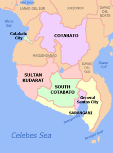
| Region | Soccsksargen (Region XII) | |
| Province | Maguindanao (geographically only) | |
| District | 1st District of Maguindanao | |
| During Manobo period | 13th century | |
| Founded as capital of Maguindanao Sultanate | c. 1520 | |
| Founding of Pueblo de Cotabato | 1862 | |
| Cityhood | June 20, 1959 | |
| Founded by | Apo Mamalu and Apo Tabunaway | |
| Barangays | 37 | |
| Government [1] | ||
| • Type | Sangguniang Panlungsod | |
| • Mayor | Frances Cynthia Guiani-Sayadi (PDP) | |
| • Vice Mayor | Graham Guiani Dumama | |
| Area [2] | ||
| • Total | 176.00 km2 (67.95 sq mi) | |
| Population (2015 census)[3] | ||
| • Total | 299,438 | |
| • Density | 1,700/km2 (4,400/sq mi) | |
| Demonym(s) |
Cotabateño (masculine) Cotabateña (feminine) | |
| Time zone | UTC+8 (PST) | |
| ZIP code | 9600 | |
| IDD : area code | +63 (0)64 | |
| Income class | 3rd city income class | |
| PSGC | 129804000 | |
| Native languages |
Maguindanao language Tagalog | |
| Revenue (₱) | 769,359,556.6 (2016) [4] | |
| Electorate | 103,530 voters as of 2016 | |
| Climate type | Tropical climate | |
| Language | Tagalog, Maguindanaon, Chavacano, Cebuano, Maranao, English | |
| City Annual Budget for 2018 (₱) | 938 million (Approved)[5] | |
| Website |
www | |

Cotabato City, officially the City of Cotabato (Maguindanaon: Kuta Wato; Filipino: Lungsod ng Cotabato) is a city in the Philippines. According to the 2015 census, it has a population of 299,438.[3]
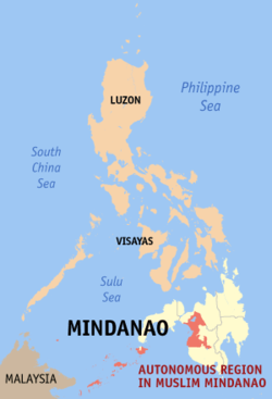
Although Cotabato City is the regional center of the Autonomous Region in Muslim Mindanao (ARMM), the city is administratively part of the Soccsksargen region, which is composed of the provinces of South Cotabato, (North) Cotabato, Sultan Kudarat, and Sarangani, as well as the highly urbanized city of General Santos. Cotabato City is an independent component city, not subject to regulation from the Provincial Government of Maguindanao where it is geographically located. The Philippine Statistics Authority also list Cotabato City as statistically independent. For geographical and legislative purposes, it is grouped with the province of Maguindanao but still does not belong to the ARMM.[6]
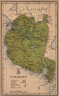
Cotabato City is distinct from and should not be confused with the province of Cotabato. The city was chartered by the virtue of Republic Act No. 2364.
History
Prior to the arrival of Hindus and Muslims, the city was a vast swamp and rainforest landscape where numerous ethno-linguistic groups lived. Maguindanao vernacular architecture developed during this era, which included the architectural techniques of at least 10 ethno-linguistic groups. Later on, Hindu traders arrived and the people of the area embraced the practice of Hinduism. The set of moral standards and culture of present-day people of Maguindanao are seen due to this Hindu influence.
Sultanate of Maguindanao
By 1515, after a successful Islamic colonization in Sulu, Muslim traders went to Maguindanao and converted many of the natives to Islam. Those that did not accept the arrival of the Muslims went into higher ground or the interior of the island. During the same year, the Sultanate of Maguindanao was formally established, with Kota Wato as its capital, and ruled a vast territory in Mindanao from until its total collapse in 1888.
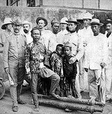
Following the Spanish evacuation in Jan. 1899, Datu Piang led the Moro's in a massacre of the remaining Christian community, enslaving those they did not kill.[7]:529–530 Americans arrived in Mindanao in 1900 after the Spanish–American War ended in 1898. Cotabato town was part of Moro Province and of Department of Mindanao and Sulu from 1903 to 1920, when the Empire Province of Cotabato, referred to as "Moroland" by the Americans, was founded with the town as the capital, with Datu Piang as its first governor.[6]
Cotabato Empire
Several towns were carved off from Cotabato town since the year 1913, with Pikit being the first one founded by Cebuano Christian colonists. Dulawan (now Datu Piang, Maguindanao) and Midsayap were incorporated as regular municipalities in 1936. In 1942, at the beginning of the Pacific Front of World War II, the Japanese Imperial forces entered what is now Maguindanao province. In 1945, Maguindanao was liberated by allied Philippine Commonwealth troops and Muslim Maguindanaoan guerrilla units after defeating the Japanese Imperial forces in the Battle of Maguindanao during the Second World War.[6] In August 18, 1947, just two years after the Second World War and a year after the official inauguration of Philippine independence, the number of towns in the gigantic Cotabato province were multiplied by Executive Order No. 82 signed by President Manuel Roxas, namely: Kidapawan, Pagalungan, Buayan, Marbel, Parang, Nuling, Dinaig, Salaman, Buluan, Kiamba, and Cabacan, a total of eleven (11) towns added to the previous four towns; the newly founded towns of Kabuntalan, Pikit (conversion as regular municipality), and Glan added up in September 30, 1949. More and more newly created towns added up in the province's number of towns as the province entered the second half of the 20th century.[6]
Cityhood Status
The city used to be part of the original Province of Cotabato and was its capital from 1920 until 1967, a year after the separation of South Cotabato; since then the city was the administrative center of the ARMM when Maguindanao was carved out in 1973. However, the city broke off administratively from Maguindanao as it rejoined Soccsksargen in the 1990s. Now many sources consider the city as part of the present Cotabato province, although geographically it is still considered part of Maguindanao.[6]
Geography
Cotabato is approximately 698.9 nautical miles (1,294.4 kilometres) from Manila, the country's capital, and is bounded by the municipalities of Sultan Kudarat to the north—with Rio Grande de Mindanao separating the two—Kabuntalan to the east, and Datu Odin Sinsuat to the south. The city faces Illana Bay, part of the Moro Gulf, to the west.
Cotabato City has a total land area of 176.0 square kilometers, located at the mouth of the Rio Grande de Mindanao and Pulangi River.[8]
Topography
The city is situated in the lowest portion of Maguindanao province. The City of Cotabato with its 37 barangays spans an area with marked landscapes of flat, level to nearly level, very gently sloping to gently undulations to moderately sloping or rolling. It is basically a delta formed by two big rivers, the Tamontaka River and the Rio Grande de Mindanao. Basically 70% of its total land area is below sea level. There are only 2 existing elevated areas in the city, the PC Hill and the Timako Hill with an altitude of 90 and 150 feet, respectively.
Concentration of settlements and other urban uses are in the central portion while the southwestern and southeastern portion have mixed uses of agricultural land settlements. The city is criss-crossed by mendering and braided creeks and rivers like the Matampay, Parang, Timako, Esteros and Miwaruy.
These water bodies serve as sources of both agricultural, industrial and domestic water requirements of some rural barangays. These rivers also serve as the natural drainage flow of the city’s wastes.
Soil profile
Broadly, there are three (3) soil types present in the area. The most dominant soil type found in Cotabato which make up 80% of the total land area or 14.079 hectares is the Faraon clay type. These are moderately good lands suitable for limited cultivation and less appropriate for urban development due to soil characteristics. Urban development would require very careful, and complex soil utilization practices. This type is found in the innermost portion of the area, the Tamontaka clay type found in the areas along Rio Grande de Mindanao on the north and south directions total to 2,640 hectares or 15% of the city’s total land area. This type of soil has high fertility level, good lands which can be cultivated and suited for urban development but requires carefully, planned erosion control measures. The third type of soil embracing an area of 880 hectares or barely 5% of the city’s total land area is where settlements and other urban uses are highly concentrated. These are very good lands which can be cultivated safely and require very simple soil management practices and with high density for urban development.
The city has been identified to be within the earthquake belt. This was clearly demonstrated during the 1976 earthquake that caused vast destruction of lives and properties.
The susceptibility of the soils in the area to be eroded were those that are Erosion Potentials located along the banks of the Matampay River, Tamontaka River and the Rio Grande de Mindanao. Barangays located along low-lying areas occasionally experience flash floods brought about by heavy rains. It is also noted, however, that more than half of the city’s land area is below sea level, thus seemingly an appropriate drainage system could prevent flooding and clogging of waterways. Potential flooding areas are those found in almost all four directions in the north, south, east and west. The meandering and occasional braided courses of rivers like Rio Grande de Mindanao, Tamontaka River, Tarbung, Kakar, Matampay, Miwaruy, Masukul, Manday, Lugay-lugay, Bagua and Kalanganan Rivers and Pagalamatan Creek could aggravate the flooding hazards of the area where these rivers are found especially during rainy season. Approximately, 85% of the soils in the area have good external and internal drainage while the other 15% have poor external and internal drainage.
Barangays
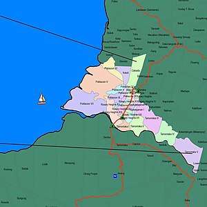
Cotabato City is politically subdivided into 37 barangays.
- Bagua Proper
- Bagua I
- Bagua II
- Bagua III
- Kalanganan
- Kalanganan I
- Kalanganan II
- Poblacion Proper
- Poblacion I
- Poblacion II
- Poblacion III
- Poblacion IV
- Poblacion V
- Poblacion VI
- Poblacion VII
- Poblacion VIII
- Poblacion IX
- Rosary Heights Proper
- Rosary Heights I
- Rosary Heights II
- Rosary Heights III
- Rosary Heights IV
- Rosary Heights V
- Rosary Heights VI
- Rosary Heights VII
- Rosary Heights VIII
- Rosary Heights IX
- Rosary Heights X
- Rosary Heights XI
- Rosary Heights XII
- Rosary Heights XIII
- Tamontaka Proper
- Tamontaka I
- Tamontaka II
- Tamontaka III
- Tamontaka IV
- Tamontaka V
Climate
Under the Köppen climate classification system, Cotabato City features a tropical rainforest climate (Af), falling just short of a tropical monsoon climate (Am).
| Climate data for Cotabato City (1981–2010, extremes 1986–2012) | |||||||||||||
|---|---|---|---|---|---|---|---|---|---|---|---|---|---|
| Month | Jan | Feb | Mar | Apr | May | Jun | Jul | Aug | Sep | Oct | Nov | Dec | Year |
| Record high °C (°F) | 36.1 (97) |
36.5 (97.7) |
37.7 (99.9) |
37.0 (98.6) |
36.0 (96.8) |
35.5 (95.9) |
35.4 (95.7) |
35.3 (95.5) |
35.4 (95.7) |
34.8 (94.6) |
35.2 (95.4) |
35.5 (95.9) |
37.7 (99.9) |
| Average high °C (°F) | 32.7 (90.9) |
32.8 (91) |
33.4 (92.1) |
33.7 (92.7) |
33.1 (91.6) |
32.3 (90.1) |
31.9 (89.4) |
32.1 (89.8) |
32.3 (90.1) |
32.2 (90) |
32.6 (90.7) |
32.5 (90.5) |
32.6 (90.7) |
| Daily mean °C (°F) | 27.8 (82) |
27.9 (82.2) |
28.3 (82.9) |
28.6 (83.5) |
28.1 (82.6) |
27.6 (81.7) |
27.3 (81.1) |
27.5 (81.5) |
27.6 (81.7) |
27.5 (81.5) |
27.8 (82) |
27.6 (81.7) |
27.8 (82) |
| Average low °C (°F) | 22.9 (73.2) |
23.1 (73.6) |
23.3 (73.9) |
23.5 (74.3) |
23.2 (73.8) |
22.8 (73) |
22.7 (72.9) |
22.9 (73.2) |
22.9 (73.2) |
22.9 (73.2) |
22.9 (73.2) |
22.8 (73) |
23.0 (73.4) |
| Record low °C (°F) | 20.0 (68) |
21.0 (69.8) |
21.0 (69.8) |
21.0 (69.8) |
21.0 (69.8) |
20.5 (68.9) |
20.6 (69.1) |
20.5 (68.9) |
20.8 (69.4) |
20.8 (69.4) |
20.7 (69.3) |
20.0 (68) |
20.0 (68) |
| Average rainfall mm (inches) | 88.4 (3.48) |
83.9 (3.303) |
119.9 (4.72) |
146.7 (5.776) |
268.5 (10.571) |
312.3 (12.295) |
325.4 (12.811) |
244.8 (9.638) |
256.6 (10.102) |
285.5 (11.24) |
216.3 (8.516) |
139.6 (5.496) |
2,487.8 (97.945) |
| Average rainy days (≥ 0.1 mm) | 9 | 9 | 11 | 11 | 17 | 20 | 19 | 16 | 16 | 17 | 14 | 12 | 171 |
| Average relative humidity (%) | 75 | 74 | 74 | 73 | 74 | 76 | 76 | 76 | 76 | 76 | 75 | 75 | 75 |
| Source: PAGASA[9][10] | |||||||||||||
Demographics
| Population census of Cotabato City | ||||||||||||||||||||||||||||||||||
|---|---|---|---|---|---|---|---|---|---|---|---|---|---|---|---|---|---|---|---|---|---|---|---|---|---|---|---|---|---|---|---|---|---|---|
|
| |||||||||||||||||||||||||||||||||
| Source: Philippine Statistics Authority[3] [11] [12] [13] | ||||||||||||||||||||||||||||||||||
The majority of the inhabitants of Cotabato City are Maguindanaoan, comprising about 50% of the city's population. There are sizable ethnic populations of Iranun (12%), Maranaos (8%), Tagalogs (8%), Cebuanos (8%), and Hiligaynons (6%). The remainder of the population belongs to other ethnicities (e.g. Binisaya, Tausug, Tiruray and Chinese).
| Gender (C 2015) | |
|---|---|
| Males | 146,934 |
| Females | 152,504 |
| Age Distribution (C 2015) | |
|---|---|
| 0–9 years | 69,562 |
| 10–19 years | 69,198 |
| 20–29 years | 53,508 |
| 30–39 years | 41,440 |
| 40–49 years | 33,071 |
| 50–59 years | 18,726 |
| 60–69 years | 9,209 |
| 70–79 years | 3,609 |
| 80+ years | 1,115 |
Language
The main language is Tagalog, making it the only Tagalog speaking city in Mindanao, Other languages spoken in Cotabato City are Maguindanao, Cebuano and Chavacano, spoken by both Christians and Muslims as well as Maranao, English and Arabic. The dialect evolved from Chavacano native to Cotabato City is called Cotabateño.
Religion
As reported by Philippine Statistics Authority (PSA) on 2015, 76.15% of the people of Cotabato City are adherent of Islam and mainly belong to Sunnites.[14] The followers of Islam are mainly Magindanao, Iranun, Maranao, and Tausug people.
The remaining proportion belong to non - Islamic belief such as Christianity, Buddhism and other sects.
Economy
Retailing industry
The city is dubbed as the shopping center and commercial hub in central mindanao, some of the Malls located in the city are the following.
- CityMall Cotabato
- Mall of Alnor
- Southseas Mall
- El Manuel City Walk
- Fiesta Mall
- Superama Hypermart
Cotabato City is also the hub of well known Supermarkets and Department stores in Central Mindanao which are.
- Robinsons Supermarket and Department Store
- Puregold which is the only branch in Soccsksargen Region
- SM Savemore
- Centro Department Store
- Superama
- Sugni
- Mi Department Store.
Cotabato City also is one of the fastest growing economy in the region, as per confirmation Cotabato City will have a KCC Mall of Cotabato, International Airport and Seaport, Sports Complex, China-Cotabato Friendship Technical School and Industrial park those projects will surely reboost cotabato city’s economy.
Aquaculture industry
Cotabato city has a more or less 1,700 hectares of fishponds which has an annual productions of 85,000 kg of mud crabs, 75,000 kg of prawn and 180,000 kg of Milkfish.
Food industry
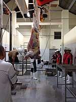
Aiming to be the halal hub of the Philippines, LGU of Cotabato and Malaysian businessman built a Class AA halal slaughter house in baranggay Kalangan II in the city primary serving the entire Central Mindanao.[15] Cotabato city also has different restaurants both local (Lesorelle, Kai’s lounge, Picante Pizza, Sugar Pappi, Chefmel, Cheraf, Maguindanaon Restaurant, Reese Restaurant, Las hermanas, Aling Precy, Elcomedor, Tati’s, Mang gorio, Pritong Manok, Manong’s, Moro Cafe and Rebecca Buffet Restaurant) and popular restaurants like McDonald’s, Jollibee, Chowking, Greenwich Pizza, Mang Inasal, Goldilocks, Red Ribbon, Chicken Deli, Mandarin Tea Garden, Queen Bee, Hukad, Calda Pizza, Bo's Coffee, Infinitea, Cafetribu and Turks Shawarma.[16]
Banking institutions
Cotabato City has one of the Highest Bank Deposits in mindanao with total of Php18,736,523,000.00 deposits as of June 30, 2017 with 150,406 bank accounts[17] the city has 20 banks (Private and Government), due to high bank deposits and good economic dynamism the Bangko Sentral ng Pilipinas built its Central Mindanao branch in the city.
Manufacturing industry
has different factories/manufacturer of cooking oil,coffee, corn starch, processed food and furniture operating on the city which helps in boosting its economy.
Also giant factories from neighboring towns has established their offices in the city like Lamsan Inc., Corn Wet Milling Company, Maria Makiling Coconut Resources Corp., Mindanao Textile Corporation, etc.

Attractions
Point of interest
.jpg)
- Rio Grande de Mindanao: Second largest river system in the Philippines.
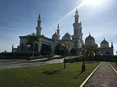
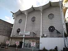
- Sultan Haji Hassanal Bolkiah Masjid: The biggest mosque in the Philippines that can accommodate approximately 15,000 worshippers.[18]
- Kutawato Caves is only cave system found in the heart of a Philippine City, it is located in the foot of PC Hill.
- Old Cotabato City Hall Museum: A century old structure which houses Marines Camp. It showcases the architectural design of the Maguindanaon Art.
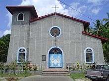
- Church of the Immaculate Conception of Tamontaka: The oldest church, of Spanish architecture and design, was built by the Jesuits. This is where the old settlement was built in 1872. During the 1976 Moro Gulf earthquake, a portion of the church collapsed but the Oblate Fathers restored the ruin parts following the original design.
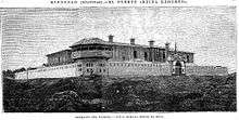
- Old Provincial Capitol: An early American architecture which was the seat of then Empire Province of Cotabato. It houses now by the reserved Military Soldiers.
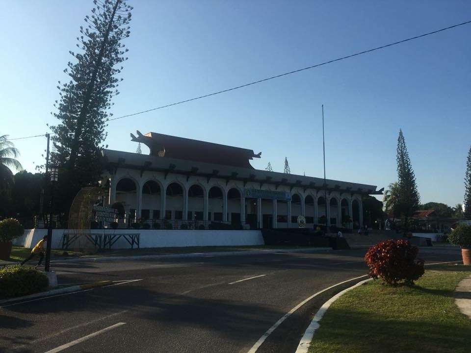
- People's Palace: A structure located at Malagapas, Barangay Rosary Heights 10 combining ethno-modern architectural with Muslim-inspired roof symbolizing its royalty and Roman art symbolizing the existence of Christianity in the City. The entire bureaucracy of the Executive Department are now housed under one roof.
- ORC Complex: The regional seat of the Autonomous Region in Muslim Mindanao a 32 hectares compound regional center located at southwest of Cotabato City which composed of different government offices of the entire region of ARMM and some offices of the SOCCSARGEN. Most buildings are built with state-of-the-art Islamic architecture.
- Tantawan Park: This park is build at the foot of Pedro Colina Hill which stand the huge golden statue of Sultan Kudarat.
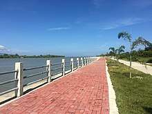
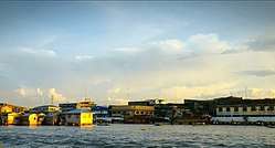
- Baywalk in Cotabato City (Bai Walk): The new emerging tourist spot in Cotabato, it was first to be just a riverbank protection project, but later on it was realize that it can be develop as a boulevard, facing the Tamontaka River part of Mindanao River and Mount Minandar, the boulevard is also named as a “sunset park” because of its beautiful scenery during sunset.
Events
- Our Lady of Peñafrancia Fiesta (3rd Sunday of September): Celebrated in honor of Our Lady of Peñafrancia hosted by the Bicolano Association of Cotabato City. This annual event is a replica of the same event in Naga City.
- Feast of the Immaculate Conception (December 8): The patroness of Cotabato City, the feast of the Immaculate Conception is held from the first day of December.
- Pakarajaan Festival (March to December): Pakaradjaan is a generic term for celebration among ethno-linguistic tribes in the island provinces of Basilan, Sulu and Tawi-Tawi in the Autonomous Region in Muslim Mindanao, highlights of the activity for 2018 are, ARMM Villages, April 16; Ramadhan Trade Fair, May 15 to June 15; Food Festival, July 23; MasterChef Competition, August 24; ARMM debate competition, September 21 to 23; Lanao del Sur cultural night, October 17; Tawi-Tawi cultural night, October 24; Sulu cultural night, October 31; Sheikh Makhdum Celebration, November 7; Basilan cultural night, November 14; Sayaw Street Dance Competition, November 19; Maguindanao cultural night, November 21; Moro Film Festival, December 4 to 7; Sports Peace Festival, November 7 to December 9; Shariff Kabunsuan, Closing Program and Awards Night, Fluvial Float Competition, December 19.
Transportation
- Air
Cotabato City can be reached via Cotabato Airport in neighboring Datu Odin Sinsuat, Maguindanao. Cebu Pacific and Philippine Airlines maintains connecting the city to Manila, Cebu and Zamboanga.
- Land
Cotabato City is accessible by land from many parts of Mindanao. Buses, jeepneys and minivans link the city to Midsayap, Koronadal, Lebak, Pagadian, Tacurong, Kidapawan, Marawi, Iligan, General Santos, Davao City and to various points in Maguindanao.
Bus operators:
- Mindanao Star daily route to Kidapawan, Digos City and Davao City
- Husky Tours daily route to Shariff Aguak, Tacurong, Koronadal and General Santos City
- Sema Express daily route to Lebak and Kalamansig
- City proper
Multicab and tricycle are the usual means of transportation around the city, minimum fare is P7. There are also Taxi roaming around the city and Habal habal. [19]
Taxi operators:
- Wow Taxi
- Alnor Taxi
Utilities
Power
Power is handled by Cotabato Light and Power Co, a private firm owned by Aboitiz who gets power resources from the Nat’l. Grid Corp. of the Phils. (NGCP). It also operates a bunker fuel-fired stand-by power engines to address emergency situations like power failures, trip-offs and fluctuations. It has a 21,191 active power connection, 2,366 of which are from commercial/industrial sector.
Water
Water is handled by Metro Cotabato Water District, a quasi-government institution. It has an active connection of 15,558 with a total of 27,100 cu.m./day Average Water Supply Demand / Day.
Telecommunications
- Telephone – Main service provider is the PLDT Co.
- Mobile Services – GlobeTelecom, Smart Communications and Sun Cellular
- Internet Providers – PLDT-DSL, Globe, SUN Cellular
- TV Cable Operators – Cotabato Cable Television Network, Cignal & Maguindanao Sky Cable
Ice Plant
Cotabato Ice Plant acquired by the Aboitiz Group of Companies 83 years ago, Ice plant is selling ice blocks in different sizes between 10kgs to 160kgs, with an average daily production of 120 tons.
Hospitals and medical facilities
The city has one (1) government hospital and six (6) private hospitals. below is the list of current operating hospitals in the city.
- Cotabato Regional and Medical Center – Sinsuat Avenue.
- Notre Dame Hospital – Sinsuat Avenue
- Cotabato Medical Specialist Hospital – Quezon Avenue
- United Doctors Hospital of Cotabato City – Notre Dame Avenue
- Dr. P. Ocampo Hospital – De Mazenod Avenue
- Cotabato Doctors Clinic and Hospital – Sinsuat Avenue
- Cotabato Puericulture Center and General Hospital Foundation, Inc. – Jose Lim Sr. St.
Education
Dub as pioneering and center for high quality education in Central Mindanao.
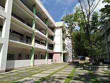
Universities and colleges:
- Notre Dame University
- Cotabato State University formerly Cotabato City State Polytechnic College
- STI Cotabato
- St.Benedict College
- Notre Dame – RVM College of Cotabato
- AMA Computer College
- Colland Systems Technology
- Headstart College of Cotabato
- A.R Pacheco College
- Notre Dame Hospital – School of Midwifery
- Doctor P. Ocampo College
- Delavida College
- Computer Aided Design and Information Technology Institute, Inc. (CAD.It)
- Jamiat Cotabato- Cotabato City University
- Academia De Technologia
- Mindanao Capitols Colleges
Media
Radio stations
FM Stations
- DXYC “Brigada News FM” 89.3Mhz
- DXWD “iFM bestfriend mo” 90.9Mhz
- DYHL “Aksyon Radyo Cotabato” 999 kHz
- DXOL “Happy FM” 92.7Mhz
- DXFD “Star FM” 93.7Mhz
- DXPS “MOR For Life!” 95.1Mhz
- DXTC “Hot FM” 95.9Mhz
- DXJC “Voice FM” 99.0Mhz
AM Stations
- DXCH “DZRH Relay” 567 kHz
- DXMY “RMN Cotabato” 729 kHz
- DXMS “Radyo Bida Cotabato” 882 kHz
Free TV stations and local programs
- ABS-CBN Channel 5 Cotabato – TV Patrol South Central Mindanao and Magandang Umaga South Central Mindanao
- GMA Channel 12 Cotabato
- ABS-CBN Sports and Action Channel 23 Cotabato
- GMA News TV Channel 27 Cotabato
- PTV Channel 8 Cotabato
Twin towns – sister cities
Cotabato City is twinned with:
Local

International


References
- ↑ "City". Quezon City, Philippines: Department of the Interior and Local Government. Retrieved 30 May 2013.
- ↑ "List of Cities". PSGC Interactive. Quezon City, Philippines: Philippine Statistics Authority. Retrieved 12 November 2016.
- 1 2 3 Census of Population (2015). "Region XII (Soccsksargen)". Total Population by Province, City, Municipality and Barangay. PSA. Retrieved 20 June 2016.
- ↑ "Philippine Cities Local Income". blgf. Retrieved 30 January 2018.
- ↑ https://tl-ph.facebook.com/BNFMCotabato/posts/1750496754981786
- 1 2 3 4 5 "Cotabato City". Philippine Information Agency, Government of the Republic of the Philippines. Archived from the original on 18 June 2017. Retrieved 7 May 2018.

- ↑ Foreman, J., 1906, The Philippine Islands: A Political, Geographical, Ethnographical, Social and Commercial History of the Philippine Archipelago, New York: Charles Scribner's Sons
- ↑ Disaster Preparedness of Schools by Abdul Raffi A. Abas
- ↑ "Cotabato City, Maguindanao Climatological Normal Values". Philippine Atmospheric, Geophysical and Astronomical Services Administration. Archived from the original on 13 October 2018. Retrieved 13 October 2018.
- ↑ "Cotabato City, Maguindanao Climatological Extremes". Philippine Atmospheric, Geophysical and Astronomical Services Administration. Archived from the original on 13 October 2018. Retrieved 13 October 2018.
- ↑ Census of Population and Housing (2010). "Region XII (Soccsksargen)". Total Population by Province, City, Municipality and Barangay. NSO. Retrieved 29 June 2016.
- ↑ Censuses of Population (1903–2007). "Region XII (Soccsksargen)". Table 1. Population Enumerated in Various Censuses by Province/Highly Urbanized City: 1903 to 2007. NSO.
- ↑ "Province of". Municipality Population Data. Local Water Utilities Administration Research Division. Retrieved 17 December 2016.
- ↑ Philippine Statistics Authority (July 26, 2017). "Muslim Population in Mindanao (based on POPCEN 2015". Retrieved Aug 31, 2018.
- ↑ "Halal industry sa Cotabato city, mas palalakasin! – RMN Networks". RMN Networks. 2017-11-08. Retrieved 2017-11-26.
- ↑ "Negosyo sa Cotabato City lumago – RMN Networks". RMN Networks. 2017-10-13. Retrieved 2017-11-26.
- ↑ "PDIC Bank Deposits". www.pdic.gov.ph. Retrieved 2018-01-31.
- ↑ Inquirer.net, July 21, 2012
- ↑ "Travel Guide: Cotabato City | Lakwatsero". www.lakwatsero.com. Retrieved 2017-10-28.
- ↑ "Cotabato City in Sisterhood with Sultan Kudarat Municipality". Cotabatocity.net.ph. Retrieved 2016-12-09.
- ↑ "Malaysian investors in Cotabato City". Cotabatocity.net.ph. Retrieved 2016-12-09.
- ↑ "Mindanao LGUs emulate best Indonesian city – The Standard". Manilastandardtoday.com. 2016-08-15. Retrieved 2016-12-09.
External links
| Wikimedia Commons has media related to Cotabato City. |
| Wikivoyage has a travel guide for Cotabato City. |
- Official Cotabato City Website
- NSCB details for cotabato city geographic code
- Philippine Census Information
- Department of Tourism
Places adjacent to Cotabato City | ||||||||||
|---|---|---|---|---|---|---|---|---|---|---|
| ||||||||||