Regions of the Philippines
 |
|---|
| This article is part of a series on the politics and government of the Philippines |
|
Constitutional commissions |
| This article is part of a series on |
| Administrative divisions of the Philippines |
|---|
|
Provinces and ind. cities |
|
Municipalities and comp. cities |
|
Barangays |
| Administrative division codes (ISO) (FIPS) |
In the Philippines, regions (Filipino: rehiyon), (ISO 3166-2:PH) are administrative divisions that serve primarily to organize the provinces (Filipino: lalawigan) of the country for administrative convenience. Currently, the archipelagic republic of the Philippines is divided into 17 regions (16 administrative and one autonomous). Most national government offices provide services through their regional branches instead of having direct provincial offices. These regional offices are usually (but not always) in the city designated as the regional center.
The regions themselves do not possess a separate local government, with the exception of the Autonomous Region in Muslim Mindanao, which has an elected regional assembly and governor. The Cordillera Administrative Region was originally intended to be autonomous (Cordillera Autonomous Region), but due to two failed plebiscites, its tentative administrative region status has been extended indefinitely.
History
Regions first came to existence in on September 24, 1972, when the provinces of the Philippines were organized into eleven regions under Presidential Decree № 1 as part of the Integrated Reorganization Plan of President Ferdinand Marcos.
Since that time, other regions have been created and some provinces have been transferred from one region to another.
- June 22, 1973: Pangasinan was transferred from Region III to Region I.[1]
- July 7, 1975: Region XII created and minor reorganization of some Mindanao regions.[2]
- July 25, 1975: Regions IX and XII declared as Autonomous Regions in Western and Central Mindanao respectively.[3]
- August 21, 1975: Region IX divided into Sub-Region IX-A and Sub-Region IX-B. Minor reorganization of some Mindanao regions.[4]
- November 7, 1975: Metropolitan Manila created.[5]
- June 2, 1978: Metropolitan Manila declared as the National Capital Region.[6]
- July 15, 1987: Cordillera Administrative Region created.[7]
- August 1, 1989: Autonomous Region in Muslim Mindanao (ARMM) created.[8] Region XII reverted to an administrative region.
- October 23, 1989: First creation of Cordillera Autonomous Region.[9] Ratification rejected by residents in a plebiscite.
- October 12, 1990: Executive Order 429 issued by President Corazon Aquino to reorganize the Mindanao regions but the reorganization never happened (possibly due to lack of government funds).[10]
- February 23, 1995: Region XIII (Caraga) created and minor reorganization of some Mindanao regions. Sultan Kudarat transferred to Region XI.[11]
- 1997: Minor reorganization of some Mindanao regions.
- December 22, 1997: Second creation of Cordillera Autonomous Region.[12] Ratification rejected by residents in a plebiscite.
- December 18, 1998: Sultan Kudarat returned to Region XII.[13]
- March 31, 2001: ARMM expanded.[14]
- September 19, 2001: Most Mindanao regions reorganized and some renamed.[15]
- May 17, 2002: Region IV-A (Calabarzon) and Region IV-B (Mimaropa) created from the former Region IV (Southern Tagalog) region. Aurora transferred to Region III.[16]
- May 23, 2005: Palawan transferred from Region IV-B to Region VI; Mimaropa renamed to Mimaro.[17]
- August 19, 2005: Transfer of Palawan to Region VI held in abeyance.[18]
- May 29, 2015: Negros Island Region (NIR) created. Negros Occidental and Bacolod from Region VI and Negros Oriental from Region VII transferred to form new region.[19]
- July 17, 2016: Republic Act No. 10879 established the Southwestern Tagalog Region (MIMAROPA Region) from the former Region IV-B (in effect merely a renaming and discontinuation of the "Region IV-B" designation since no boundary changes were involved).[20]
- August 9, 2017: Executive Order No. 38 was signed by President Rodrigo Duterte abolishing the Negros Island Region.[21]
List of regions
Administrative regions

As of August 2017, the Philippines comprises 17 administrative regions, with one being autonomous.[22] These regions are geographically organized into the three island groups of Luzon, Visayas and Mindanao.
The names of regions Calabarzon, Mimaropa, and Soccsksargen are acronyms signifying their component provinces and cities; and are capitalized in official government documents.
Table of regions
- Component local government units: the data column is limited to primary LGUs, which pertains to component provinces, highly urbanized cities and independent component cities, as well as the independent municipality of Pateros. All city names, except those under the National Capital Region, are italicized.
- Location: the location map column can be sorted from North-to-South, West-to-East.
| Location | Region (regional designation) |
PSGC[23] | Island group |
Regional center |
Component local government units |
Area[A] | Population (2015)[24] |
Density | |
|---|---|---|---|---|---|---|---|---|---|
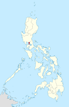 |
National Capital Region (NCR) |
13 | Luzon | Manila | 619.57 km2 (239.22 sq mi) |
12,877,253 (12.75%) |
21,000/km2 (54,000/sq mi) | ||
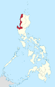 |
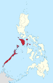
Ilocos Region (Region I) |
01 | Luzon | San Fernando (La Union) |
13,012.60 km2 (5,024.19 sq mi) |
5,026,128 (4.98%) |
390/km2 (1,000/sq mi) | ||
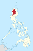 |
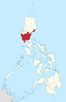
Cordillera Administrative Region (CAR) |
14 | Luzon | Baguio | 19,422.03 km2 (7,498.89 sq mi) |
1,722,006 (1.71%) |
89/km2 (230/sq mi) | ||
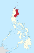 |
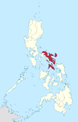
Cagayan Valley (Region II) |
02 | Luzon | Tuguegarao | 28,228.83 km2 (10,899.21 sq mi) |
3,451,410 (3.42%) |
120/km2 (310/sq mi) | ||
 |
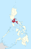
Central Luzon (Region III) |
03 | Luzon | San Fernando (Pampanga) |
22,014.63 km2 (8,499.90 sq mi) |
11,218,177 (11.11%) |
510/km2 (1,300/sq mi) | ||
 |
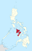
CALABARZON (Region IV-A) |
04 | Luzon | Calamba | 16,873.31 km2 (6,514.82 sq mi) |
14,414,774 (14.27%) |
850/km2 (2,200/sq mi) | ||
 |
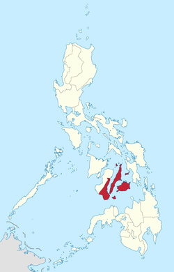
Southwestern Tagalog Region (MIMAROPA Region) |
17 | Luzon | Calapan | 29,620.90 km2 (11,436.69 sq mi) |
2,963,360 (2.93%) |
100/km2 (260/sq mi) | ||
 |
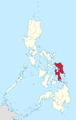
Bicol Region (Region V) |
05 | Luzon | Legazpi | 18,155.82 km2 (7,010.00 sq mi) |
5,796,989 (5.74%) |
320/km2 (830/sq mi) | ||
 |
Western Visayas (Region VI) |
06 | Visayas | Iloilo City | 20,794.18 km2 (8,028.68 sq mi) |
7,536,247 (7.46%) |
360/km2 (930/sq mi) | ||
 |
Central Visayas (Region VII) |
07 | Visayas | Cebu City | 15,487.69 km2 (5,979.83 sq mi) |
7,396,903 (7.33%) |
480/km2 (1,200/sq mi) | ||
 |
Eastern Visayas (Region VIII) |
08 | Visayas | Tacloban | 23,251.10 km2 (8,977.30 sq mi) |
4,440,150 (4.40%) |
190/km2 (490/sq mi) | ||
 |
Zamboanga Peninsula (Region IX) |
09 | Mindanao | Pagadian | 17,056.73 km2 (6,585.64 sq mi) |
3,629,783 (3.59%) |
210/km2 (540/sq mi) | ||
 |
Northern Mindanao (Region X) |
10 | Mindanao | Cagayan de Oro | 20,496.02 km2 (7,913.56 sq mi) |
4,689,302 (4.64%) |
230/km2 (600/sq mi) | ||
 |
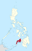
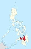
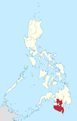
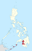
Davao Region (Region XI) |
11 | Mindanao | Davao City | 20,357.42 km2 (7,860.04 sq mi) |
4,893,318 (4.85%) |
240/km2 (620/sq mi) | ||
 |
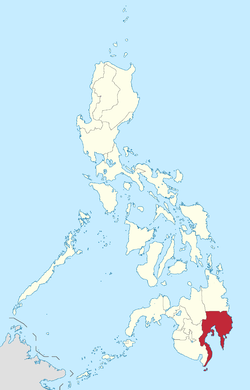
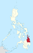
SOCCSKSARGEN (Region XII) |
12 | Mindanao | Koronadal | 22,513.30 km2 (8,692.43 sq mi) |
4,545,276 (4.5%) |
200/km2 (520/sq mi) | ||
 |
Caraga Region (Region XIII) |
16 | Mindanao | Butuan | 21,478.35 km2 (8,292.84 sq mi) |
2,596,709 (2.57%) |
120/km2 (310/sq mi) | ||
 |
Autonomous Region in Muslim Mindanao (ARMM) |
15 | Mindanao | Cotabato City | 12,535.79 km2 (4,840.10 sq mi) |
3,781,387 (3.74%) |
300/km2 (780/sq mi) | ||
| |||||||||
Judicial regions
As far as the Judiciary is concerned, specifically the first and second level courts, the country is divided into judicial regions as provided by Batas Pambansa Bilang 129. The coverage of these judicial regions generally coincides with that of the administrative regions in the Executive branch of government.
Proposed regions
- Bangsamoro (proposed as a replacement of the ARMM. Includes areas outside the current ARMM.)
- Cordillera Autonomous Region[31] (proposed to convert the Cordillera Administrative Region into an autonomous region.)
- Samar Administrative Region [32]
- Bangsasug[33][34][35][36] (proposed to separate the Sulu Archipelago from the mainland portion of ARMM/Bangsamoro)
Defunct regions
The following are regions that no longer exist, listed along with their current status:
- Southern Tagalog (Region IV, now divided into CALABARZON and MIMAROPA)
- Western Mindanao (renamed as Zamboanga Peninsula, still designated as Region IX)
- Central Mindanao (now mostly SOCCSKSARGEN, still designated as Region XII)
- Southern Mindanao (renamed as Davao Region, still designated as Region XI)
- Negros Island Region (abolished; Negros Occidental reverted to Western Visayas and Negros Oriental to Central Visayas)
See also
References
- ↑ "Presidential Decree № 224". Retrieved November 5, 2016.
- ↑ "Presidential Decree No. 742; Restructuring the Regional Organization of Mindanao, Basilan, Sulu and Tawi-Tawi". The Lawphil Project. July 7, 1975. Retrieved June 6, 2015.
- ↑ "Presidential Decree No. 1618; Implementing the Organization of the Sangguniang Pampook and the Lupong Tagapagpaganap ng Pook in Region IX and Region XII and for Other Purposes". The Lawphil Project. July 25, 1975. Retrieved June 6, 2015.
- ↑ "Presidential Decree No. 773; Amending Presidential Decree No. 742 Restructuring the Regional Organization of Mindanao and Dividing Region IX into Two Sub-regions". The Lawphil Project. August 21, 1975. Retrieved June 6, 2015.
- ↑ "Presidential Decree No. 824; Creating the Metropolitan Manila and the Metropolitan Manila Commission and for Other Purposes". The Lawphil Project. November 7, 1975. Retrieved June 6, 2015.
- ↑ "Presidential Decree No. 1396, s. 1978; Creating the Department of Human Settlements and the Human Settlement Development Corporation, Appropriation Funds Therefor, and Accordingly Amending Certain Presidential Decrees". Official Gazette of the Republic of the Philippines. Retrieved September 22, 2015.
- ↑ "Executive Order No. 220; Creating a Cordillera Administrative Region, Appropriating Funds Therefor and for Other Purposes". The Lawphil Project. July 15, 1987. Retrieved June 6, 2015.
- ↑ "Republic Act No. 6734; An Act Providing for an Organic Act for the Autonomous Region in Muslim Mindanao". The Lawphil Project. August 1, 1989. Retrieved June 6, 2015.
- ↑ "Republic Act No. 6766; An Act Providing for an Organic Act for the Cordillera Autonomous Region". The Lawphil Project. October 23, 1989. Retrieved June 6, 2015.
- ↑ "Executive Order No. 429 s. 1990; Providing for the Reorganization of the Administrative Regions in Mindanao, and for Other Purposes". The Lawphil Project. October 12, 1990. Retrieved June 6, 2015.
- ↑ "Republic Act No. 7901; An Act Creating Region XIII to be Known as the Caraga Administrative Region, and for Other Purposes". Chan Robles Virtual Law Library. February 23, 1995. Retrieved June 6, 2015.
- ↑ "Republic Act No. 8438; An Act to Establish the Cordillera Autonomous Region". The Lawphil Project. December 22, 1997. Retrieved June 6, 2015.
- ↑ "Republic Act No. 8744; An Act Repealing Section 3 of Republic Act No 7901 and to Return the Province of Sultan Kudarat to Region XII and for Other Purposes". The Lawphil Project. December 18, 1998. Retrieved June 6, 2015.
- ↑ "Republic Act No. 9054; An Act to Strengthen and Expand the Organic Act for the Autonomous Region in Muslim Mindanao, Amending for the Purpose Republic Act No. 6734, Entitled "An Act Providing for the Autonomous Region in Muslim Mindanao," as Amended". The Lawphil Project. March 31, 2001. Retrieved June 6, 2015.
- ↑ "Executive Order No. 36;Providing for the Reorganization of the Administrative Regions in Mindanao and for Other Purposes". The Lawphil Project. September 19, 2001. Retrieved June 6, 2015.
- ↑ "Executive Order No. 103; Dividing Region IV into Region IV-A and Region IV-B, Transferring the Province of Aurora to Region III and for Other Purposes". The Lawphil Project. May 17, 2002. Retrieved June 6, 2015.
- ↑ "Executive Order No. 429; Providing for the Reorganization of Administrative Region VI to Include the Province of Palawan and Puerto Princesa City". The Lawphil Project. May 23, 2005. Retrieved June 6, 2015.
- ↑ "Administrative Order No. 129; Directing the Department of the Interior and Local Government to Hold in Abeyance the Implementation of Executive Order No. 429 (s. 2005) Pending Its Submission of an Implementation Plan and Its Subsequent Approval By the Office of the President". Philippine Statistics Authority. August 19, 2005. Archived from the original on February 19, 2006. Retrieved June 6, 2015.
- ↑ "Executive Order No. 183, s. 2015; Creating a Negros Island Region and for Other Purposes". Official Gazette (Philippines). May 29, 2015. Retrieved June 6, 2015.
- ↑ "An Act establishing the Southwestern Tagalog Region, to be known as the MIMAROPA Region". July 17, 2016. Retrieved January 4, 2017.
- ↑ "BREAKING: President Rodrigo Duterte issues E.O. 38, which revokes the creation of Negros Island Region". CNN Philippines. August 9, 2017. Retrieved August 9, 2017.
- ↑ List of Regions Archived 2008-10-27 at WebCite, National Statistical Coordination Board'"'.
- ↑ "Philippine Standard Geographic Codes as of 31 December 2015". PSGC Interactive. Philippine Statistics Authority. Retrieved 15 March 2016.
- ↑ "Highlights of the Philippine Population 2015 Census of Population". 2015 Census of Population. Philippine Statistics Authority. 19 May 2016. Retrieved 20 May 2016.
- 1 2 3 4 5 An independent component city, not under the jurisdiction of any provincial government.
- 1 2 3 4 5 6 7 8 9 10 11 12 13 14 15 16 17 A highly urbanized city, independent from any province.
- ↑ A component city, part of the province of Basilan, but whose regional services are provided by the offices of Region IX.
- ↑ "PSGC Interactive; List of Provinces". Philippine Statistics Authority. Retrieved 3 April 2016.
- ↑ "PSGC Interactive; List of Cities". Philippine Statistics Authority. Retrieved 7 April 2016.
- ↑ For provinces in the ARMM: "Bangsamoro Development Plan Integrative Report, Chapter 10" (PDF). Bangsamoro Development Agency. 2015. Retrieved 2016-05-31.
- ↑ "Cordillera Solons expressed views on regional autonomy". National Economic and Development Authority - Cordillera Administrative Region. 12 August 2013. Retrieved 28 February 2015.
- ↑ "Bishops call for separate Samar administrative region". GMA News. 15 June 2016. Retrieved 18 September 2017.
- ↑ "Sulu Sultanate, Bangsa Sug push revision of BBL". Sun-Star. 10 May 2018. Retrieved 31 August 2018.
- ↑ "10,000 people benefit from Bangsa Sug Iftar convention". PressReader.com (The Mindanao Examiner). 25 May 2018. Retrieved 31 August 2018.
- ↑ "Why is autonomy tied to peace talks?". Inquirer.net. 18 August 2015. Retrieved 31 August 2018.
- ↑ "10,000 people to benefit from Bangsa Sug Iftar Caravan in Zamboanga City". Mindanao Examiner. 23 May 2018. Retrieved 31 August 2018.
External links
| Wikimedia Commons has media related to Regions of the Philippines. |
Philippines articles | |||||||||||||||||||||
|---|---|---|---|---|---|---|---|---|---|---|---|---|---|---|---|---|---|---|---|---|---|
| History |
| | |||||||||||||||||||
| Geography | |||||||||||||||||||||
| Politics |
| ||||||||||||||||||||
| Economy | |||||||||||||||||||||
| Society |
| ||||||||||||||||||||
| |||||||||||||||||||||