Muhlenberg County, Kentucky
| Muhlenberg County, Kentucky | |
|---|---|
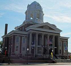 Muhlenberg County Courthouse in Greenville | |
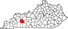 Location in the U.S. state of Kentucky | |
 Kentucky's location in the U.S. | |
| Founded | 1798 |
| Named for | Peter Muhlenberg |
| Seat | Greenville |
| Largest city | Central City |
| Area | |
| • Total | 479 sq mi (1,241 km2) |
| • Land | 467 sq mi (1,210 km2) |
| • Water | 12 sq mi (31 km2), 2.6% |
| Population | |
| • (2010) | 31,839 |
| • Density | 67/sq mi (26/km2) |
| Congressional district | 1st |
| Time zone | Central: UTC−6/−5 |
| Website |
https://muhlenbergcounty.ky.gov/ www https: |
Muhlenberg County (/ˈmjuːlənbɜːrɡ/) is a county located in the U.S. Commonwealth of Kentucky. As of the 2010 census, the population was 31,499.[1] Its county seat is Greenville.[2] The county was founded in 1798,[3] and was named for General Peter Muhlenberg, a colonial general during the American Revolutionary War.[4]
On February 5, 2008, Greenville, Powderly, and Central City were damaged and three people were killed during the 2008 Super Tuesday tornado outbreak.
History
Muhlenberg County was formed in 1798 from portions of the previous Logan and Christian counties. Muhlenberg was the 34th Kentucky county in order of formation.[5]
Geography
According to the U.S. Census Bureau, the county has a total area of 479 square miles (1,240 km2), of which 467 square miles (1,210 km2) is land and 12 square miles (31 km2) (2.6%) is water.[6]
Features
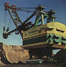
The two primary aquatic features of Muhlenberg County are the Green River and Lake Malone. The northern portion of the county is typically gently rolling hills, river flatlands, and some sizeable bald cypress swamps along Cypress Creek and its tributaries. The southern portion consists of rolling hills with higher relief. Many of the valleys in the southern part of the county are rather deep and somewhat rugged. This area is known for many sandstone formations. Two limestone caves are thought to be in the southern part of the county. Several north-south-oriented faults cross the county's midpoint. Coal is found in these faults, across the county's central part. Most remaining deposits reside deep underground; previous near-surface deposits have now been exhausted. In former years, it was common to see machines such as the "Big Brother" Power Shovel (pictured on the right) throughout the county. During the 1970s and early 1980s, Muhlenberg County was the state leader in coal production and sometimes the top coal producer in the United States. This was the subject of the song "Paradise" by John Prine.
Sandstone is the county's most abundant rock type, although limestone becomes more common toward the southern portion. Two mines for extracting iron ore have been attempted, at Old Airdrie on the banks of the Green River, and at Buckner Furnace south of Greenville, Kentucky. Both operations were extant in the late 19th century and early 20th century; neither enjoyed long-term success.
Green River
The 300 miles (483 km)-long Green River is a tributary of the Ohio River. It provides a commercial outlet for goods (primarily coal) to be shipped from the county to the major trade centers along the Mississippi River.
Lake Malone
Lake Malone (788 acres (3.19 km2)) is in southern Muhlenberg County near Dunmor. It, and a portion of the surrounding hardwood forest, form Lake Malone State Park, maintained by the Kentucky Department of Fish and Wildlife. The lake's surface extends into two neighboring counties, Todd and Logan. There are sandstone cliffs and natural sandstone formations along the lake shore including a natural bridge, although the bridge itself is not inside the park boundary.
Adjacent counties
- McLean County (north)
- Ohio County (northeast)
- Butler County (east)
- Logan County (southeast)
- Todd County (south)
- Christian County (southwest)
- Hopkins County (west)
Demographics
| Historical population | |||
|---|---|---|---|
| Census | Pop. | %± | |
| 1800 | 1,293 | — | |
| 1810 | 4,181 | 223.4% | |
| 1820 | 4,979 | 19.1% | |
| 1830 | 5,340 | 7.3% | |
| 1840 | 6,964 | 30.4% | |
| 1850 | 9,809 | 40.9% | |
| 1860 | 10,725 | 9.3% | |
| 1870 | 12,638 | 17.8% | |
| 1880 | 15,098 | 19.5% | |
| 1890 | 17,955 | 18.9% | |
| 1900 | 20,741 | 15.5% | |
| 1910 | 28,598 | 37.9% | |
| 1920 | 33,353 | 16.6% | |
| 1930 | 37,784 | 13.3% | |
| 1940 | 37,554 | −0.6% | |
| 1950 | 32,501 | −13.5% | |
| 1960 | 27,791 | −14.5% | |
| 1970 | 27,537 | −0.9% | |
| 1980 | 32,238 | 17.1% | |
| 1990 | 31,318 | −2.9% | |
| 2000 | 31,839 | 1.7% | |
| 2010 | 31,499 | −1.1% | |
| Est. 2016 | 31,028 | [7] | −1.5% |
| U.S. Decennial Census[8] 1790-1960[9] 1900-1990[10] 1990-2000[11] 2010-2013[1] | |||
As of the census[12] of 2010, there were 31,499 people, 12,979 households, and 9,057 families residing in the county. The population density was 67 per square mile (26/km2). There were 13,675 housing units at an average density of 29 per square mile (11/km2). The racial makeup of the county was 94.19% White, 4.65% Black or African American, 0.13% Native American, 0.13% Asian, 0.19% from other races, and 0.72% from two or more races. 0.73% of the population were Hispanic or Latino of any race.
There were 12,979 households out of which 30.70% had children under the age of 18 living with them, 59.70% were married couples living together, 10.40% had a female householder with no husband present, and 26.70% were non-families. 24.30% of all households were made up of individuals and 12.60% had someone living alone who was 65 years of age or older. The average household size was 2.45 and the average family size was 2.90.
In the county, the population was spread out with 22.60% under the age of 18, 9.20% from 18 to 24, 28.00% from 25 to 44, 24.80% from 45 to 64, and 15.50% who were 65 years of age or older. The median age was 39 years. For every 100 females there were 98.00 males. For every 100 females age 18 and over, there were 96.20 males.
The median income for a household in the county was $28,566, and the median income for a family was $33,513. Males had a median income of $29,952 versus $18,485 for females. The per capita income for the county was $14,798. About 15.50% of families and 19.70% of the population were below the poverty line, including 26.00% of those under age 18 and 17.00% of those age 65 or over.
Economy
Muhlenberg County has been a major coal-producing region for the United States for many years; during most of the 1970s, Muhlenberg County annually produced more coal than anywhere else in the world. Although coal mining in the county waned in the late 1980s and early 1990s, as the 21st century began, the coal-mining industry in Muhlenberg and surrounding counties began to expand and has once again provided a significant number of jobs in the region. One reason for this is the willingness of utility operators to install flue gas cleaning systems so that bituminous coal can be burned with fewer airborne contaminants. Another reason is that most coal from the western US has a lower BTU content.
Muhlenberg County held Kentucky's first commercial coal mine, opened in 1820 as the "McLean Drift Bank" along the Green River in the former village of Paradise. The mine and its impact on the community are referenced in the John Prine song Paradise. Other major employers in Muhlenberg County include:
- The Tennessee Valley Authority Paradise Fossil Plant in Drakesboro
- The Green River Correctional Complex in Central City
- Dyno Nobel in Graham
- EBA&D in Graham
- Muhlenberg Community Hospital in Greenville
- Muhlenberg County Board of Education in Powderly
- Kentucky National Guard Wendell H. Ford Regional Training Center & Kentucky UTES
- Armstrong Coal Company in Central City
- Ken-American Resources: Paradise Underground Mine in Central City
- Kentucky Utilities Green River Generating Station in Central City
- Wal-Mart in Central City.
- Uncle Lee's / Wing Supply in Greenville, Kentucky
- Gourmet Express in Greenville[13]
Chamber of commerce
In January 2006, the chambers of commerce from Central City and Greenville merged to form the Greater Muhlenberg Chamber of Commerce representing over 155 local businesses.[14]
Incoming industries
Peabody Energy's proposed Thoroughbred Energy Plant, a coal-burning power generation facility expected to bring 450 permanent jobs to the area, was to be located in Central City.[15] The plant was projected to begin electricity generation in 2007,[16] but a dispute over Peabody's air quality permit halted construction plans.[17] The power plant plans have now been scrapped, as was a later partnership between Peabody Energy and ConocoPhillips Oil Company called, "Kentucky NewGas".[18]
Education
Schools
Public schools in Muhlenberg County are operated by the Muhlenberg County Board of Education. They include:
Elementary (K-5)
- Bremen Elementary School in Bremen
- Central City Elementary School in Central City
- Greenville Elementary School in Greenville
- Longest Elementary School in Powderly
- Muhlenberg South Elementary School in Beechmont
Middle (6-8)
- Muhlenberg North Middle School in Powderly
- Muhlenberg South Middle School in Greenville
High (9-12)
Postsecondary
- Muhlenberg Campus of Madisonville Community College (Central City)
- Muhlenberg Career Development Center (between Central City & Greenville)
Former schools
- Drakesboro Elementary School in Drakesboro (closed in 2006)
- Graham Elementary School in Graham (closed in 2004)
- Hughes-Kirkpatrick Elementary School in Beechmont (closed in 2006)
- Lake Malone Elementary School in Dunmor (closed in 2005)
- Muhlenberg North High School (closed in 2009)
- Muhlenberg South High School (closed in 2009)
Libraries
- Harbin Memorial Library in Greenville is a public library, with free access to high-speed internet
- Central City Library in Central City is a public library, with free access to high-speed internet.
These libraries are operated as Muhlenberg County Library.
History of education
At one time the county hosted eight secondary schools. Drakesboro Community closed after the class of 1964 graduated and in 1990, the school board consolidated the middle and high school students into two middle and two high schools. Bremen High School, Central City High School, Graham High School, and half of Muhlenberg Central High School became Muhlenberg North Middle School and Muhlenberg North High School, while the other half of Muhlenberg Central High School, Drakesboro High School, Hughes-Kirkpatrick High School, Greenville High School, and Lake Malone School (which housed some middle school students) became Muhlenberg South Middle School and Muhlenberg South High School. The eight distinct schools continued to house elementary school students.
In 2004, the school board began consolidating the elementary schools, closing Graham Elementary School and transferring students to Longest Elementary Greenville Elementary Schools; closing Lake Malone School and transferring students to Hughes-Kirkpatrick Elementary School. In 2005 Drakesboro Elementary School was closed, with students first attending Hughes-Kirkpatrick Elementary and then Muhlenberg South Elementary School (2006). Hughes-Kirkpatrick was later closed.
Muhlenberg North and Muhlenberg South High Schools were merged into a single Muhlenberg County High School in June 2009.
Media
- WMTA AM 1380 Radio (1955) Central City
- WNES AM 1050 Radio (1955) Central City
- Times Argus (1909) Central City
- Leader-News established in Greenville, now located in Central City
- SurfKY News (2008). Based in Madisonville, this online news service serves Muhlenberg County and surrounding counties.
- WKYA FM 105.5 Radio Greenville
- WQXQ FM 101.9 Radio studio in Central City, transmitter at Pleasant Ridge, Kentucky in Ohio County
Sites of interest
- Lake Malone State Park in Dunmor
- Muhlenberg County Rail to Trails, 6-mile (9.7 km) converted railroad track between Central City and Greenville
- Brewco Motorsports shop in Central City]
- Thistle Cottage, a museum and art gallery in Greenville (now part of Muhlenberg County Public Libraries)
- Four Legends Fountain in Drakesboro
- Muhlenberg County Agriculture and Convention Center in Powderly
- Morgan Memorial Park in Greenville
- The Muhlenberg County Park, a sports facility adjacent to the Muhlenberg County High School west campus in Greenville
- The Brizendine Brothers Nature Park in Greenville
- Luzerne Lake City Park in Greenville
- Paradise Park in Powderly, includes:
- Coal Mines Shotgun House
- Merle Travis Birthplace
- Paradise Park Museum
- Springridge School
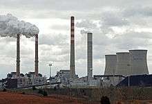
- Tennessee Valley Authority Paradise Fossil Plant in Drakesboro, one of the nation's largest Coal-Fired Power Plants. Site includes:
- Public Boat Launch Ramp along the Green River
- Public Fishing Lakes
- Historic Village of Paradise Cemetery, the only remnant of the village along the Green River.
Central City Convention Center, Fitness Facility and Outdoor Pool & Spray Park in Central City
- Muhlenberg County Courthouse (1907) in Greenville
- Muhlenberg County Veterans Mall and Plaza in Greenville
- Lt. Ephraim Brank Memorial & Trail, at Greenville's Veteran's Mall
- The Pillars of Community have enhanced the beauty of downtown Greenvile by adding "Art to Restoration". The locations include:
- FAITH - United Methodist Church on North Main Street
- FAMILY - Across from the MCTI Theater on North Main Street
- ENTERPRISE - Between Edward Jones Investments & 1st KY Bank
- PATRIOTISM - At the United States Post Office on Courts Street
- EDUCATION - In front of Greenville Elementary School on East Main Cross
- ARTS - In front of Thistle Cottage on Cherry Street
- HEALTH - In front of Muhlenberg Community Hospital
- TEAMWORK - At Martin Ground along East Main Cross
- Historic Gristmill Stone, adjacent to the Veterans Mall at the Muhlenberg County Courthouse
- The Summerhouse, a gazebo in Greenville
Annual events
- Rods and Ribs BBQ Festival in Central City the first Saturday in June
- Labor Day Cruise-In in Central City
- Saturdays on the Square - summers in Greenville
- Squash & Gobble arts bazaar and fall festival - Greenville
- The "Clodhopper" Vintage Tractor Show - Greenville.
Politics
| Year | Republican | Democratic | Third parties |
|---|---|---|---|
| 2016 | 71.9% 9,393 | 25.1% 3,272 | 3.0% 395 |
| 2012 | 60.9% 7,762 | 37.5% 4,771 | 1.6% 206 |
| 2008 | 50.0% 6,447 | 48.3% 6,221 | 1.7% 221 |
| 2004 | 50.1% 6,749 | 49.2% 6,636 | 0.7% 94 |
| 2000 | 46.2% 5,518 | 52.7% 6,295 | 1.2% 143 |
| 1996 | 31.4% 3,569 | 57.7% 6,564 | 11.0% 1,253 |
| 1992 | 27.1% 3,551 | 60.3% 7,901 | 12.7% 1,662 |
| 1988 | 43.6% 5,369 | 56.1% 6,912 | 0.3% 41 |
| 1984 | 49.6% 6,094 | 50.2% 6,157 | 0.2% 26 |
| 1980 | 41.8% 4,893 | 56.5% 6,616 | 1.7% 197 |
| 1976 | 37.5% 4,292 | 61.7% 7,058 | 0.9% 99 |
| 1972 | 62.3% 5,596 | 36.2% 3,246 | 1.5% 136 |
| 1968 | 39.5% 3,853 | 37.8% 3,688 | 22.7% 2,209 |
| 1964 | 33.9% 3,300 | 65.9% 6,421 | 0.2% 20 |
| 1960 | 57.4% 5,968 | 42.6% 4,427 | 0.0% 0 |
| 1956 | 52.6% 5,323 | 47.0% 4,752 | 0.4% 38 |
| 1952 | 48.5% 4,761 | 51.3% 5,037 | 0.1% 14 |
| 1948 | 42.6% 3,478 | 54.3% 4,426 | 3.1% 254 |
| 1944 | 55.6% 4,618 | 44.0% 3,657 | 0.4% 29 |
| 1940 | 50.8% 5,332 | 49.0% 5,140 | 0.3% 28 |
| 1936 | 39.2% 4,168 | 60.1% 6,385 | 0.7% 75 |
| 1932 | 37.4% 4,349 | 61.6% 7,162 | 1.0% 119 |
| 1928 | 56.2% 6,651 | 43.4% 5,130 | 0.4% 49 |
| 1924 | 49.8% 5,210 | 41.8% 4,379 | 8.4% 882 |
| 1920 | 56.7% 6,667 | 41.0% 4,824 | 2.2% 262 |
| 1916 | 53.5% 3,533 | 43.9% 2,900 | 2.6% 168 |
| 1912 | 18.6% 1,038 | 37.4% 2,093 | 44.1% 2,465[20] |
Communities
Cities
- Bremen
- Central City
- Drakesboro
- Greenville (county seat)
- Powderly
- South Carrollton
Census-designated places
Other unincorporated places
Notable people
- James Best (Sheriff Rosco P. Coltrane of the Dukes of Hazzard), born in Powderly
- Don Everly of The Everly Brothers singing duo, born in now-defunct Brownie, near Central City
- Harpe Brothers, Micajah and Wiley, the nation's first known serial-killers
- Kennedy Jones, guitarist
- Warren Oates, actor, born in Depoy near Greenville
- Merle Travis, western musician, born in Rosewood
See also
References
- 1 2 "State & County QuickFacts". United States Census Bureau. Archived from the original on 15 July 2011. Retrieved 6 March 2014.
- ↑ "Find a County". National Association of Counties. Archived from the original on 31 May 2011. Retrieved 7 June 2011.
- ↑ "Welcome - Muhlenberg County, Kentucky". www.muhlenbergcounty.ky.gov. Archived from the original on 2013-02-18.
- ↑ The Register of the Kentucky State Historical Society, Vol. 1. Kentucky State Historical Society. 1903. p. 36.
- ↑ Collins, Lewis (1882). Collins' Historical Sketches of Kentucky: History of Kentucky, Volume 2. Collins & Co. p. 26.
- ↑ "2010 Census Gazetteer Files". United States Census Bureau. 22 August 2012. Archived from the original on 12 August 2014. Retrieved 18 August 2014.
- ↑ "Population and Housing Unit Estimates". Archived from the original on 29 May 2017. Retrieved 9 June 2017.
- ↑ "U.S. Decennial Census". United States Census Bureau. Archived from the original on 12 May 2015. Retrieved 18 August 2014.
- ↑ "Historical Census Browser". University of Virginia Library. Archived from the original on 16 August 2012. Retrieved 18 August 2014.
- ↑ "Population of Counties by Decennial Census: 1900 to 1990". United States Census Bureau. Archived from the original on 13 October 2014. Retrieved 18 August 2014.
- ↑ "Census 2000 PHC-T-4. Ranking Tables for Counties: 1990 and 2000" (PDF). United States Census Bureau. Archived (PDF) from the original on 18 December 2014. Retrieved 18 August 2014.
- ↑ "American FactFinder". United States Census Bureau. Archived from the original on 11 September 2013. Retrieved 31 January 2008.
- ↑ "Major Employers in Muhlenberg County Kentucky". mafp.us. Archived from the original on 2 May 2014.
- ↑ Greater Muhlenberg Chamber of Commerce - Message from the President Archived 24 May 2009 at the Wayback Machine.
- ↑ Peabody Archived 18 July 2011 at the Wayback Machine.
- ↑ "News Releases". phx.corporate-ir.net.
- ↑ Bruggers, James (8 August 2007). "Ruling delays power plant in Western Ky". The Courier-Journal. Archived from the original on 29 July 2012. Retrieved 8 August 2007.
- ↑ "Kentucky NewGas — zeroco2". www.zeroco2.no. Archived from the original on 8 May 2015.
- ↑ Leip, David. "Dave Leip's Atlas of U.S. Presidential Elections". uselectionatlas.org. Archived from the original on 23 March 2018.
- ↑ The leading "other" candidate, Progressive Theodore Roosevelt, received 1,699 votes, while Socialist candidate Eugene Debs received 766 votes.
External links
- Muhlenberg County Schools
- Greater Muhlenberg Chamber of Commerce
- Photos of the damage path caused by the 2008 Super Tuesday tornado outbreak
Municipalities and communities of Muhlenberg County, Kentucky, United States | ||
|---|---|---|
| Cities | | |
| CDPs | ||
| Unincorporated communities | ||
| Ghost town | ||
| Footnotes | ‡This populated place also has portions in an adjacent county or counties | |
