Natural arch

%2C_by_Klugschnacker_in_Wikipedia_(31).JPG)
A natural arch, natural bridge, or (less commonly) rock arch is a natural rock formation where an arch has formed with an opening underneath. Natural arches commonly form where inland cliffs, coastal cliffs, fins or stacks are subject to erosion from the sea, rivers or weathering (subaerial processes).
Most natural arches are formed from narrow fins and sea stacks composed of sandstone or limestone with steep, often vertical, cliff faces. The formations become narrower due to erosion over geologic time scales. The softer rock stratum erodes away creating rock shelters, or alcoves, on opposite sides of the formation beneath the relatively harder stratum, or caprock, above it. The alcoves erode further into the formation eventually meeting underneath the harder caprock layer, thus creating an arch. The erosional processes exploit weaknesses in the softer rock layers making cracks larger and removing material more quickly than the caprock; however, the caprock itself continues to erode after an arch has formed, which will ultimately lead to collapse.
The choice between bridge and arch is somewhat arbitrary. The Natural Arch and Bridge Society identifies a bridge as a subtype of arch that is primarily water-formed.[1] By contrast, the Dictionary of Geological Terms defines a natural bridge as a "natural arch that spans a valley of erosion."[2]
The largest natural arch, by a significant margin, is the Xianren Bridge in China, with a span of 122 ± 5 meters (400 ± 15 ft).[3]
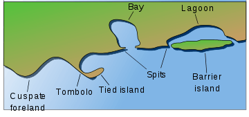
Coastline
.jpg)
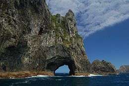
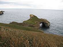
On coasts two different types of arches can form depending on the geology. On discordant coastlines rock types run at 90° to the coast. Wave refraction concentrates the wave energy on the headland, and an arch forms when caves break through the headland. Two examples of this type of arch are London Arch—previously known as London Bridge—in Victoria, Australia, and Neill Island in the Andaman Islands, India. When these arches eventually collapse, they form stacks and stumps. On concordant coastlines rock types run parallel to the coastline, with weak rock such as shale protected by stronger rock such as limestone. The wave action along concordant coastlines breaks through the strong rock and then erodes the weak rock very quickly. Good examples of this type of arch are the Durdle Door and Stair Hole near Lulworth Cove on Dorset's Jurassic Coast in south England. When Stair Hole eventually collapses it will form a cove.
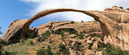
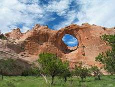
Weather-eroded arches

Weather-eroded arches begin their formation as deep cracks which penetrate into a sandstone layer. Erosion occurring within the cracks wears away exposed rock layers and enlarges the surface cracks isolating narrow sandstone walls which are called fins. Alternating frosts and thawing cause crumbling and flaking of the porous sandstone and eventually cut through some of the fins. The resulting holes become enlarged to arch proportions by rockfalls and weathering. The arches eventually collapse leaving only buttresses that in time will erode.[4]
Many weather-eroded arches are found in Arches National Park, Canyonlands National Park, and Grand Staircase-Escalante National Monument, all located in southern Utah, United States.
Water-eroded arches
Some natural bridges may look like arches, but they form in the path of streams that wear away and penetrate the rock. Pothole arches form by chemical weathering as water collects in natural depressions and eventually cuts through to the layer below.

Natural Bridges National Monument in Utah protects the area surrounding three large natural bridges, all of which were formed by streams running through canyons, the largest of which is named Sipapu Bridge with a span of 225 feet (69 m). The Rainbow Bridge National Monument's namesake was also formed by flowing water which created the largest known natural bridge in the Western Hemisphere with a span of 234 feet (71 m), based on a laser measurement made in 2007. Xianren Bridge, also known as Fairy Bridge, in Guangxi, China is currently the world's largest known natural bridge with a span recorded at 400 feet (120 m) by the Natural Arch and Bridge Society in October 2010, with a precision of ±15 feet (4.6 m).[5][6]
Cave erosion
Natural bridges can form from natural limestone caves, where paired sinkholes collapse and a ridge of stone is left standing in between, with the cave passageway connecting from sinkhole to sinkhole.
Like all rock formations, natural bridges are subject to continued erosion, and will eventually collapse and disappear. One example of this was the double-arched Victorian coastal rock formation, London Bridge, which lost an arch after storms increased erosion.[7]
Moon Hill in Yangshuo, Guizhou Province, China, is an example of an arch formed by the remnant of a karst limestone cave.
Arches as highway or railway bridges
In a few places in the world, natural arches are utilized by humans as transportation bridges with highways or railroads running across them.
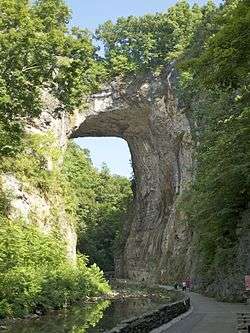
In Virginia, US Route 11 traverses Natural Bridge. Two additional natural arch roadways are found in Kentucky. The first arch, a cave erosion arch made of limestone, is located in Carter Caves State Resort Park and it has a paved road on top. The second arch, a weather-eroded sandstone arch with a dirt road on top, is located on the edge of Natural Bridge State Park in Kentucky. The latter arch is called White's Branch Arch (also known as the Narrows) and the road going over it is usually referred to as the Narrows Road.
In Europe, the Romanian village of Ponoarele has a road 60 m long and 13 m wide, passing over a stone arch 4 m thick, 20 m high, with a 9 m span. The arch is called God's Bridge (Podul lui Dumnezeu).
In South America, the railroad from Lima, Peru crosses the Rio Yauli on a natural bridge near kilometer 214.2 as it approaches the city of La Oroya, Peru.
Notable natural arches
Africa
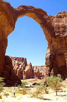
- Aloba Arch, Chad
- Boatswain Bird Island, Ascension Island
- Bogenfels, Namibia
- Goedehoop natural rock bridge, South Africa
- Hole-in-the-Wall, Eastern Cape, South Africa
- Tassili n'Ajjer, a mountain range with many arches, Algeria
- Tukuyu natural bridge, Tanzania
- Wolfberg Arch, Cederberg, Western Cape, South Africa
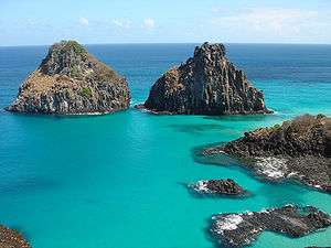
Asia
.JPG)
- Arch Cave, Galilee, Israel
- Burdah Bridge, Wadi Rum, Jordan
- Baatara gorge waterfall in Tannourine, Lebanon has three natural bridges.
- Engetsu Island, Shirahama, Wakayama, Japan
- Hawrah Natural Bridge, Neill Island, Andaman Islands, India
- Hazarchishma Natural Bridge, Bamyan Province, Afghanistan
- Jabal Umm Fruth Bridge, Jordan
- Jebel Kharaz, Wadi Rum, Jordan
- "Jisr al-Hajar" or the "Stone Bridge" in Mzaar Kfardebian, Lebanon
- Elephant Trunk Hill, Guilin, Guangxi province, China
- Moon Hill, Guangxi province, China
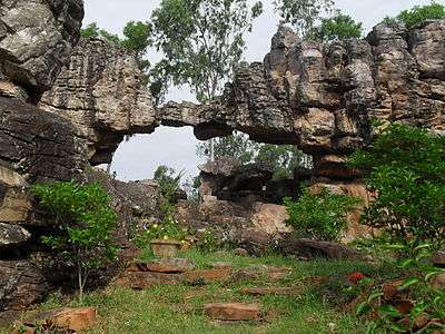
- Natural Arch, Tirumala hills, Tirumala, India
- The Pigeons' Rock known as Raouché in Beirut, Lebanon
- Punarjani Guha, natural tunnel in Thrissur district of Kerala, India
- Rock Bridge of Gulanchwadi, Narayangaon, Maharashtra, India[8]
- Shipton's Arch, Xinjiang, China
- Steller's Arch on Bering Island, Russia
- Tianmen Mountain, Zhangjiajie, China
- Xianren Bridge, China
- The Great White Hole of Krabi, Krabi, Thailand[9]
Europe
.jpg)

- Albandeira Arch, Lagoa, Algarve, Portugal
- Arco Naturale, Capri, Italy
- Azure Window, Gozo, Malta[10] (collapsed in 2017)
- Bow Fiddle Rock, Portknockie, Scotland
- Castell de Castells, Spain
- Chaos de Montpellier-le-Vieux, France
- Durdle Door, Dorset, England
- Dyrhólaey, Iceland
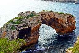
- Es Pontàs, Spain
- Étretat, France
- Għar Qawqla, Gozo, Malta (collapsed in the 20th century)
- Green Bridge of Wales, Pembrokeshire, Wales
- Inland Sea, Gozo, Malta[10]
- Kuhstall, Germany
- Malá Pravčická brána, Czech Republic
- Marinha Beach, Caramujeira, Lagoa, Algarve, Portugal
- Marsden Rock, South Shields, England (collapsed in 1996)
- Marvelous Bridges, Bulgaria
- Monte Forato, Tuscany, Italy
- Ófærufoss, Iceland (collapsed in winter 1992/1993)
- Pistyll Rhaeadr, Wales
- Ponoarele, Romania (Podul lui Dumnezeu, or God's Bridge)
- Pont d'Arc, France
- Pravčická brána, Czech Republic
- Wied il-Mielaħ Window, Gozo, Malta[10]
North America
Canada
Caribbean
- Natural Bridge, Aruba (collapsed 2005)
Mexico

United States
- Anacapa Island, Channel Islands National Park, California
- Arch Creek, Florida
- Arch Rock, Michigan
- Ayres Natural Bridge Park, Wyoming
- Bell Smith Springs, Illinois
- Blackwater Natural Bridge, Wyoming
- Bryce Canyon National Park, Utah
- Corona Arch, Utah
- Creelsboro Natural Bridge, Kentucky
- Delicate Arch, Utah
- Eye of the Needle, Montana
- Goat Rock Beach, California
- Grosvenor Arch, Utah
- Holei Sea Arch, Hawaii Volcanoes National Park, Hawaii
- Honopū Arch, Hawaii
- Koger Arch, Kentucky[12]
- Kolob Arch, Zion National Park, Utah
- Landscape Arch, Utah
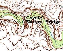
- Natural Arch, Kentucky[13][14]
- Natural Bridge, Virginia
- Natural Bridge Caverns, Texas
- Natural Bridge Park, Alabama
- Natural Bridge State Park, Kentucky
- Natural Bridge State Park, Massachusetts
- Natural Bridge State Park, Wisconsin
- Natural Bridges National Monument, Utah
- Natural Bridges State Beach, California
- Rainbow Bridge National Monument, Utah
- Rattlesnake Canyon, Colorado
- Rockbridge State Nature Preserve, Ohio
- Sewanee Natural Bridge, Tennessee
- Sipapu Bridge, Utah
- Three Arch Rocks National Wildlife Refuge, Oregon
- Tonto Natural Bridge, Arizona
- Twin Arches, Big South Fork National River and Recreation Area, Tennessee[15]
- Window Rock, Arizona
- Wrather Arch, Arizona
- Yahoo Arch, Kentucky
Oceania
Australia
- London Arch, Port Campbell National Park, Victoria, Australia (one of the two spans collapsed in 1990)
- Natural Bridge, Springbrook National Park, Queensland, Australia
New Zealand
- Mangapohue Natural Bridge, New Zealand
- Oparara Basin Arches, New Zealand
- Piercy Island, The Hole in the Rock, Cape Brett, New Zealand
- Tunnel Beach arch, Dunedin, New Zealand
South America
Other
- The Arch of Kerguelen, Christmas Harbour, Kerguelen Islands (collapsed ca. 1910)[16]
- Scott Island in the Antarctic has a natural arch.
See also
References
- ↑ Natural Arch and Bridge Society Archived 2009-08-31 at the Wayback Machine., FAQ.
- ↑ American Geological Institute, Dictionary of Geological Terms, 1976, Doubleday Anchor
- ↑ Big 14 Tour - Fairy Bridge Archived 2017-04-20 at the Wayback Machine., The Natural Arch and Bridge Society
- ↑ "Geology Resources, Arches National Park". National Park Service. Archived from the original on 2015-12-23. Retrieved 2015-12-23.
- ↑ Jett, Stephen C.China Diary Archived 2013-12-29 at the Wayback Machine., The Natural Arch and Bridge Society
- ↑ "Big 17 Tour - Measurement of Fairy Bridge". www.naturalarches.org. Archived from the original on 2013-11-12.
- ↑ "Port Campbell". www.trekearth.com. Archived from the original on 2008-09-08.
- ↑ Offbeat Tracks in Maharashtra - A Travel Guide - Book by Milind Gunaji ISBN 81-7154-669-2
- ↑ "Gallery - Thailand - White Hole". www.naturalarches.org. Archived from the original on 2017-03-04.
- 1 2 3 Ian Ellis, ed. (2011). Richard Ellis - The Photography Collection: Malta & Gozo. 4. p. 100. ISBN 978-99957-33-29-2. Archived from the original on 2016-04-30.
- ↑ "The Worlds Longest Natural Spans". www.naturalarches.org. Natural Arch and Bridge Society. Archived from the original on December 25, 2016. Retrieved January 10, 2017.
- ↑ "Koger Arch, Kentucky" Archived 2017-04-20 at the Wayback Machine.. naturalarches.org. The Natural Arch and Bridge Society. Retrieved November 6, 2017.
- ↑ "Natural Arch". Kentucky Society of Professional Geologists. Archived from the original on 2015-12-23. Retrieved 2015-12-23.
- ↑ "Natural Arch of Kentucky" Archived 2017-04-19 at the Wayback Machine.. naturalarches.org. The Natural Arch and Bridge Society. Retrieved November 6, 2017.
- ↑ "Big South Fork National River and Recreation Area: Twin Arches". nps.gov. April 14, 2015. Retrieved March 14, 2018.
- ↑ http://www.discoverfrance.net/France/DF_guestbook.shtml, Ian C. Mills, c/o The Wharton Group, P.O. Box 165, Vernon, CT 06066-0165 -- E-mail:. "Kerguelen Islands, French Southern and Antarctic Lands (Part 1) - Iles Kerguelen, TAAF". www.discoverfrance.net. Archived from the original on 2012-01-17.
External links
| Wikimedia Commons has media related to Natural arches. |
- The Natural Arch and Bridge Society

- World map of many natural arches