Monticello, Minnesota
| Monticello, Minnesota | |
|---|---|
| City | |
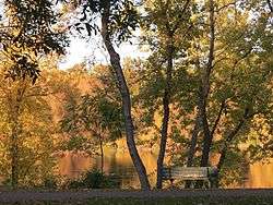 A beautiful fall day along the Mississippi River at Ellison Park. Monticello, MN | |
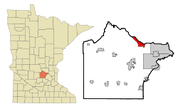 Location of the city of Monticello within Wright County, Minnesota | |
| Coordinates: 45°18′2″N 93°47′48″W / 45.30056°N 93.79667°W | |
| Country | United States |
| State | Minnesota |
| County | Wright |
| Area[1] | |
| • Total | 8.94 sq mi (23.15 km2) |
| • Land | 8.94 sq mi (23.15 km2) |
| • Water | 0 sq mi (0 km2) |
| Elevation | 925 ft (282 m) |
| Population (2010)[2] | |
| • Total | 12,759 |
| • Estimate (2016)[3] | 13,429 |
| • Density | 1,400/sq mi (550/km2) |
| Time zone | UTC-6 (Central (CST)) |
| • Summer (DST) | UTC-5 (CDT) |
| Area code(s) | 763 |
| FIPS code | 27-43774[4] |
| GNIS feature ID | 0648048[5] |
| Website | www.ci.monticello.mn.us |
Monticello (/ˌmɒntɪˈsɛloʊ/ MONT-i-SEL-oh) is a city in located next to the Mississippi River in Wright County, Minnesota, United States. The population was 12,759 at the 2010 census.[6]
Monticello is a vibrant small city tucked up against the Mississippi River and conveniently located between St. Cloud and the Twin Cities. This growing community offers an array of business, dining, and retail opportunities as well as a wide variety of recreational activities.
Monticello is proud of its extensive parks and pathway system, which includes 28 city owned and maintained parks and miles upon miles of winding trails. Lake Maria State Park, Montissippi Regional Park and the Harry Larsen Memorial Park are three of the largest. At Swan Park, each winter between December and March, as many as 2,700 trumpeter swans nest near Mississippi Drive in Monticello, as the Mississippi River is heated from warm water discharged by the Monticello Nuclear Generating Plant.
The City of Monticello and Wright County have partnered in an effort to acquire 1,200 acres of open space in Wright County, known as the Bertram Chain of Lakes. The 1,200 acres of the Bertram Chain of Lakes property represents 4 lakes, acres of undisturbed shoreline, natural habitat, and oak forest. Currently, the park features 812 acres open for public enjoyment. The park provides users access to 4 miles of hiking trails, 10 miles of single track mountain biking trails, beach at Bertram Lake for swimming , and carry-in access to Long Lake which allow the opportunity to paddle Long, Mud and First Lakes. Winter activities include fat-biking, snow shoeing, cross country skiing, and more. Summer activities include paddle board classes, canoeing excursions, kids fishing programs, guided moonlight hiking, and more.
Geography
According to the United States Census Bureau, the city has a total area of 8.94 square miles (23.15 km2), all of it land.[1] The city's latitude is 45.305 degrees North and its longitude is 93.793 degrees West. Its elevation is 922 feet. It is in the Central time zone. Lake Maria State Park is nearby.
History
Monticello was platted in 1854.[7] A post office has been in operation at Monticello since 1855.[8] Monticello was incorporated in 1856.[7]
On May 3, 2006, the Monticello Middle School had an electrical fire from the large amount of rain settling on the roof. The smoke damage to the school caused the school to be closed for the rest of the school year. As a result, middle school and high school students had to share usage of the high school building on an alternate-day schedule. The school year did not get extended, and the clean up was completed in time for the 2006–2007 school year.
Economy
In anticipation of rapid population growth, Monticello created a comprehensive growth plan in 1996. A new high school was constructed in 1999. A new highway interchange was completed in 2006 on the east end of town, allowing residents full access to Interstate 94 from Wright County Road 18. Since 2002, many retail outlets have been constructed, including Fleet Farm, Wal-Mart Supercenter, SuperTarget store, Muller Family Movie Theatre, River City Extreme Bowling & Restaurant, Home Depot, Marshalls, Applebee's, Taco John's, Arby's, Dollar Tree, Auto Zone, Aldi and Goodwill. This planned growth has also brought new auto dealerships, hotels, and industrial development. A 2004 annexation agreement with Monticello Township is expected to help sustain Monticello's growth for the next twenty years.
Education
Monticello High School (1,314 est.) is Wright County's third largest school. The nickname for the school's athletic teams is the Magic (it used to be called the Redmen but changed in order to prevent it from being offensive). Its main rivals are Buffalo High School (1,596) and St. Michael-Albertville High School
Athletics
Boys' basketball is a notable Monticello High School athletic program. The team made several trips to the state tournament in the 1990s, and from 2004 to 2006. The team's highest tournament finish is 4th place, igniting humorous theories of a possible "4th place curse". Two Minnesota high-school basketball Players of the Year have come out of Monticello, Nate Holmstadt and Joel Przybilla. The 7-foot Przybilla went on to play for the University of Minnesota, and was a center in the NBA. Varsity tennis has also gone to state each year from 2004 to 2010. The girls' cross country team was Class AA state champions and rated 3rd in the nation in 2011. The Boys Golf Team won numerous Conference Championships from 1971 thru 1980 and had an individual runner up , Mark Frie, in the State Tournament in 1976.
The Moose Sherritt Ice Arena, attached to the Middle School, was completed in 2005 due to the efforts of the Monticello–Annandale–Maple Lake Youth Hockey Organization, community members, the mayor, the city council, the school board, businesses and the Sherritt family. "Moose" Sherritt played for the NHL's Detroit Red Wings and the USHL's Minneapolis Millers among other teams in the 1940s.
Demographics
| Historical population | |||
|---|---|---|---|
| Census | Pop. | %± | |
| 1880 | 290 | — | |
| 1890 | 503 | 73.4% | |
| 1900 | 818 | 62.6% | |
| 1910 | 858 | 4.9% | |
| 1920 | 1,024 | 19.3% | |
| 1930 | 924 | −9.8% | |
| 1940 | 1,076 | 16.5% | |
| 1950 | 1,231 | 14.4% | |
| 1960 | 1,477 | 20.0% | |
| 1970 | 1,636 | 10.8% | |
| 1980 | 2,830 | 73.0% | |
| 1990 | 4,941 | 74.6% | |
| 2000 | 7,868 | 59.2% | |
| 2010 | 12,759 | 62.2% | |
| Est. 2016 | 13,429 | [3] | 5.3% |
| U.S. Decennial Census[9] 2015 Estimate[10] | |||
As of 2000 the median income for a household in the city was $45,384, and the median income for a family was $53,566. Males had a median income of $41,057 versus $25,854 for females. The per capita income for the city was $19,229. About 4.2% of families and 4.6% of the population were below the poverty line, including 4.8% of those under age 18 and 7.4% of those age 65 or over.
2010 census
As of the census[2] of 2010, there were 12,759 people, 4,693 households, and 3,164 families residing in the city. The population density was 1,427.2 inhabitants per square mile (551.0/km2). There were 4,973 housing units at an average density of 556.3 per square mile (214.8/km2). The racial makeup of the city was 92.6% White, 1.5% African American, 0.5% Native American, 1.0% Asian, 2.3% from other races, and 2.1% from two or more races. Hispanic or Latino of any race were 5.4% of the population.
There were 4,693 households of which 43.1% had children under the age of 18 living with them, 49.2% were married couples living together, 12.2% had a female householder with no husband present, 6.0% had a male householder with no wife present, and 32.6% were non-families. 25.5% of all households were made up of individuals and 9.5% had someone living alone who was 65 years of age or older. The average household size was 2.68 and the average family size was 3.23.
The median age in the city was 31.4 years. 30.8% of residents were under the age of 18; 7.7% were between the ages of 18 and 24; 33.3% were from 25 to 44; 18.7% were from 45 to 64; and 9.5% were 65 years of age or older. The gender makeup of the city was 49.2% male and 50.8% female.
Media
Newspapers
The local newspaper is The Monticello Times.
Notable people
- Joel Przybilla – an American professional basketball player, who last played for the Milwaukee Bucks of the NBA. He is a Monticello High School alumni.
References
- 1 2 "US Gazetteer files 2010". United States Census Bureau. Archived from the original on 2012-07-14. Retrieved 2012-11-13.
- 1 2 "American FactFinder". United States Census Bureau. Retrieved 2012-11-13.
- 1 2 "Population and Housing Unit Estimates". Retrieved June 9, 2017.
- ↑ "American FactFinder". United States Census Bureau. Retrieved 2008-01-31.
- ↑ "US Board on Geographic Names". United States Geological Survey. 2007-10-25. Retrieved 2008-01-31.
- ↑ "2010 Census Redistricting Data (Public Law 94-171) Summary File". American FactFinder. U.S. Census Bureau, 2010 Census. Retrieved 23 April 2011.
- 1 2 Upham, Warren (1920). Minnesota Geographic Names: Their Origin and Historic Significance. Minnesota Historical Society. p. 588.
- ↑ "Wright County". Jim Forte Postal History. Retrieved 1 August 2015.
- ↑ United States Census Bureau. "Census of Population and Housing". Retrieved June 17, 2016.
- ↑ "Population Estimates". United States Census Bureau. Archived from the original on October 19, 2016. Retrieved June 17, 2016.
External links
- Monticello – Official City Website
- Discover Monticello website
- Monticello Chamber of Commerce website
- Monticello Community Center website
- Monticello School District website
- Monticello Times website
- Monticello Arts Council Website
- Monticello History Website
Municipalities and communities of Wright County, Minnesota, United States | ||
|---|---|---|
| Cities |  | |
| Townships | ||
| CDP | ||
| Unincorporated communities | ||
| Ghost town | ||
| Footnotes | ‡This populated place also has portions in an adjacent county or counties | |
Coordinates: 45°18′20.52″N 93°47′39.12″W / 45.3057000°N 93.7942000°W