Kula, Serbia
| Kula Кула | ||
|---|---|---|
| Town and municipality | ||
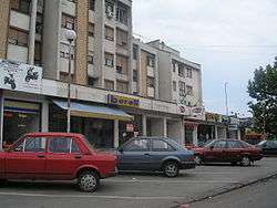 Town center of Kula | ||
| ||
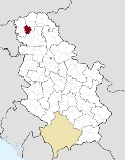 Location of the municipality of Kula within Serbia | ||
| Coordinates: 45°36′N 19°32′E / 45.600°N 19.533°ECoordinates: 45°36′N 19°32′E / 45.600°N 19.533°E | ||
| Country |
| |
| Province | Vojvodina | |
| District | West Bačka | |
| Settlements | 7 | |
| Government | ||
| • Mayor | Perica Videkanić | |
| Area[1] | ||
| • Municipality | 481 km2 (186 sq mi) | |
| Elevation | 88 m (289 ft) | |
| Population (2011 census)[2] | ||
| • Town | 17,866 | |
| • Municipality | 43,101 | |
| Time zone | UTC+1 (CET) | |
| • Summer (DST) | UTC+2 (CEST) | |
| Postal code | 25230 | |
| Area code | +381 25 | |
| Car plates | SO | |
| Website |
www | |

Kula (Serbian Cyrillic: Кула) is a town and municipality located in the West Bačka District of the autonomous province of Vojvodina, Serbia. The town has a population of 17,866, while the municipality has a population of 43,101.
Name
In Serbian, the town is known as Kula (Кула); in Rusyn as Кула, in Hungarian as Kúla, in Croatian as Kula, in German as Kula or Wolfsburg, and in Turkish as Kula.
The name Kula means "tower" in Turkish and Serbian. In the 16th-17th century, a tower with Ottoman military garrison existed at this location, hence the name of the town. However it cannot be said for sure whether Ottoman Turks or local Serbs gave this name to the town.
History
In the middle of the 17th century, during Ottoman administration, two settlements with this name were mentioned - Gornja Kula and Donja Kula. These settlements were part of the Ottoman Sanjak of Segedin and were populated by ethnic Serbs. From the end of the 17th century, the region was under administration of the Habsburg Monarchy and two settlements were mentioned as Mala Kula and Velika Kula and were unpopulated. In 1714, there was a record about single settlement named Kula that had 14 houses. In 1733, the population of the settlement numbered 251 houses and its inhabitants were Serbs. Hungarians started to settle there in 1740 and Germans in 1780-85.
Until the middle of the 19th century, the settlement was part of the Batsch-Bodrog County within the Habsburg Kingdom of Hungary. In 1848-49 it was part of the autonomous Serbian Vojvodina and from 1849-60 it was part of the Voivodeship of Serbia and Banat of Temeschwar, a separate Habsburg crownland. After abolishment of the voivodeship in 1860, the settlement was again included into Batsch-Bodrog County. In the second half of the 19th century some Rusyns were settled here as well.
After 1867, colonization of Hungarians was intensified, and until the beginning of the 20th century they replaced Serbs as largest ethnic group in Kula. According to the 1910 census the population of Kula was ethnically mixed: from the total population of 9,119 there was 3,679 speakers of Hungarian, 2,510 speakers of Serbian, 2,425 speakers of German, and 456 speakers of Rusyn.
After 1918, the settlement was part of the Kingdom of Serbs, Croats and Slovenes (later renamed to Kingdom of Yugoslavia). In 1918-19, it was part of the Banat, Bačka and Baranja region, and also (from 1918-22) part of the Novi Sad County. From 1922-29, it was part of the Bačka Oblast, and from 1929-41 part of the Danube Banovina. During World War II, From 1941-44, Kula was under Axis occupation and was attached to the Horthy's Hungary.
In 1944, the Soviet Red Army and Yugoslav partisans expelled Axis troops from the region and Kula was included into autonomous province of Vojvodina within new socialist Yugoslavia. Since 1945, Vojvodina is part of the People's Republic of Serbia within Yugoslavia.
According to 1953 census, Hungarians were the largest ethnic group in the town, while subsequent censuses recorded Serb ethnic plurality. The German community left Kula at the end of World War II, while a sizable number of Serb Montenegrins from Montenegro settled there instead of Germans. After the breakup of Yugoslavia (1991-1992) and Serbia and Montenegro (2006), the town became part of an independent Republic of Serbia. Today the Serbs are the largest ethnic group in the town.
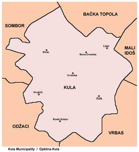
Inhabited places
The Kula municipality includes the towns of Kula and Crvenka, and also the following villages:
Demographics
| Historical population | ||
|---|---|---|
| Year | Pop. | ±% p.a. |
| 1948 | 39,488 | — |
| 1953 | 41,622 | +1.06% |
| 1961 | 46,062 | +1.28% |
| 1971 | 48,727 | +0.56% |
| 1981 | 49,898 | +0.24% |
| 1991 | 49,311 | −0.12% |
| 2002 | 48,353 | −0.18% |
| 2011 | 43,101 | −1.27% |
| Source: [3] | ||
According to the last official census done in 2011, the municipality of Kula has 43,101 inhabitants.[4]
Ethnic groups in the Kula municipality
- Serbs (58.55%)
- Rusyns (10.64%)
- Montenegrins (10.06%)
- Hungarians (7.92%)
- Ukrainians (2.99%)
- Croats (1.32%)
- Others and undeclared (8.52%)
Settlements by ethnic majority
Settlements with a Serb ethnic majority are: Lipar, Nova Crvenka, Sivac, and Crvenka. The settlement with a Rusyn ethnic majority is Ruski Krstur. Ethnically mixed settlements are: Kula (with a relative Serb majority) and Kruščić (with a relative Montenegrin majority).
Ethnic groups in the Kula town
The town of Kula has a total of 26,867 inhabitants, including:[4]
- Serbs (63.29%)
- Hungarians (9.98%)
- Montenegrins (9.51%)
- Ukrainians (3.99%)
- Rusyns (2.64%)
- Croats (1.39%)
- Others and undeclared (9.20%)
Languages in the Kula municipality
77% of the inhabitants of the Kula municipality declared Serbian as their mother language in a 2002 census.
Economy
The following table gives a preview of total number of employed people per their core activity (as of 2016):[5]
| Activity | Total |
|---|---|
| Agriculture, forestry and fishing | 532 |
| Mining | - |
| Processing industry | 1,737 |
| Distribution of power, gas and water | 25 |
| Distribution of water and water waste management | 219 |
| Construction | 218 |
| Wholesale and retail, repair | 1,270 |
| Traffic, storage and communication | 487 |
| Hotels and restaurants | 228 |
| Media and telecommunications | 36 |
| Finance and insurance | 94 |
| Property stock and charter | 2 |
| Professional, scientific, innovative and technical activities | 174 |
| Administrative and other services | 289 |
| Administration and social assurance | 358 |
| Education | 782 |
| Healthcare and social work | 314 |
| Art, leisure and recreation | 69 |
| Other services | 144 |
| Total | 6,978 |
Politics
There is an initiative among the inhabitants of Crvenka and Ruski Krstur that these two settlements become their own municipalities, completely separate from Kula.
Sports
There is a football club named Hajduk Kula in the town.
Notable citizens
- Isidor Bajic, a former Serbian composer, pedagogue, and publisher.
- Duško Grujić, a former Serbian football player
- Dragan Škrbić, a former Serbian handball player.
- Goran Gogić, a former Serbian football player.
- Zdravko Misovic a former Serbian runner.
See also
Gallery
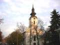 The Orthodox church.
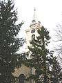 Saint George the Martyr Catholic Church.
 Seventh-day Adventist Church.
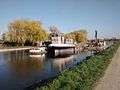 View of Canal in Kula
References
- ↑ "Municipalities of Serbia, 2006". Statistical Office of Serbia. Retrieved 2010-11-28.
- ↑ "2011 Census of Population, Households and Dwellings in the Republic of Serbia: Comparative Overview of the Number of Population in 1948, 1953, 1961, 1971, 1981, 1991, 2002 and 2011, Data by settlements" (PDF). Statistical Office of Republic Of Serbia, Belgrade. 2014. ISBN 978-86-6161-109-4. Retrieved 2014-06-27.
- ↑ "2011 Census of Population, Households and Dwellings in the Republic of Serbia" (PDF). stat.gov.rs. Statistical Office of the Republic of Serbia. Retrieved 12 December 2017.
- 1 2 "Population by ethnicity – Kula". Statistical Office of the Republic of Serbia (SORS). Retrieved 28 February 2013.
- ↑ "ОПШТИНЕ И РЕГИОНИ У РЕПУБЛИЦИ СРБИЈИ, 2017" (PDF). stat.gov.rs (in Serbian). Statistical Office of the Republic of Serbia. Retrieved 16 March 2018.
External links
- Official site
- Facebook page
- Unofficial site
- KulaWiFi
- Kula online community
- “A Home for Town Planning Kula-Odzaci” Kula
- LDP Kula - Liberal Democratic Party M.O. Kula
Cities, towns and villages in the West Bačka District | ||
|---|---|---|
| Sombor |  | |
| Apatin | ||
| Kula | ||
| Odžaci | ||
bold are municipalities or cities | ||


