Sendenhorst
| Sendenhorst | ||
|---|---|---|
| ||
 Sendenhorst Location of Sendenhorst within Warendorf district 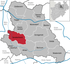  | ||
| Coordinates: 51°50′38″N 7°49′40″E / 51.84389°N 7.82778°ECoordinates: 51°50′38″N 7°49′40″E / 51.84389°N 7.82778°E | ||
| Country | Germany | |
| State | North Rhine-Westphalia | |
| Admin. region | Münster | |
| District | Warendorf | |
| Government | ||
| • Mayor | Berthold Streffing (CDU) | |
| Area | ||
| • Total | 96.66 km2 (37.32 sq mi) | |
| Elevation | 68 m (223 ft) | |
| Population (2016-12-31)[1] | ||
| • Total | 13,182 | |
| • Density | 140/km2 (350/sq mi) | |
| Time zone | CET/CEST (UTC+1/+2) | |
| Postal codes | 48324 | |
| Dialling codes |
02526 Sendenhorst 02535 Albersloh | |
| Vehicle registration | WAF | |
| Website | www.sendenhorst.de | |

Sendenhorst is a town in the district of Warendorf, in North Rhine-Westphalia, Germany. It is situated approximately 20 km (12 mi) north of Hamm and 20 km (12 mi) south-east of Münster.
Geography
Sendenhorst consists of Sendenhorst and Albersloh. Before the municipal reform of 1975, Sendenhorst was located in the former Beckum District and Albersloh in the former district of Münster (Landkreis). The river Werse flows through Albersloh.
Towns and municipalities in Warendorf (district) | ||
|---|---|---|
References
- ↑ "Amtliche Bevölkerungszahlen" (in German). Landesbetrieb Information und Technik NRW. Retrieved 2018-02-24.
This article is issued from
Wikipedia.
The text is licensed under Creative Commons - Attribution - Sharealike.
Additional terms may apply for the media files.