Porterville, Mississippi
| Porterville | |
|---|---|
| Unincorporated community | |
 Porterville Location within the state of Mississippi | |
| Coordinates: 32°41′16″N 88°28′20″W / 32.68778°N 88.47222°WCoordinates: 32°41′16″N 88°28′20″W / 32.68778°N 88.47222°W | |
| Country | United States |
| State | Mississippi |
| County | Kemper |
| Elevation | 200 ft (60 m) |
| Time zone | UTC-6 (Central (CST)) |
| • Summer (DST) | UTC-5 (CDT) |
| ZIP codes | 39352 |
| GNIS feature ID | 676260[1] |
Porterville (also Maryville) is an unincorporated community in Kemper County, Mississippi. It lies a slight distance away from U.S. Route 45 southeast of the city of De Kalb, the county seat of Kemper County.[2] Its elevation is 200 feet (61 m).[1] Although it is unincorporated, it has a post office, with the ZIP code of 39352.[3] It is adjacent to Lake Porterville.
References
- 1 2 "Porterville, Mississippi". Geographic Names Information System. United States Geological Survey. Retrieved 2008-02-17.
- ↑ Rand McNally. The Road Atlas '08. Chicago: Rand McNally, 2008, p. 56.
- ↑ Zip Code Lookup
Municipalities and communities of Kemper County, Mississippi, United States | ||
|---|---|---|
| Towns | 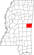 | |
| CDP | ||
| Other communities |
| |
| Ghost town | ||
| Indian reservation | ||
| Footnotes | ‡This populated place also has portions in an adjacent county or counties | |
This article is issued from
Wikipedia.
The text is licensed under Creative Commons - Attribution - Sharealike.
Additional terms may apply for the media files.