Mississippi Highway 33
| ||||
|---|---|---|---|---|
| Route information | ||||
| Maintained by MDOT | ||||
| Length | 44.959 mi[1] (72.354 km) | |||
| Major junctions | ||||
| South end |
| |||
|
| ||||
| East end |
| |||
| Location | ||||
| Counties | Jefferson, Franklin, Amite, Wilkinson | |||
| Highway system | ||||
| ||||

Mississippi Highway 33 (MS 33) is a state highway in southwestern Mississippi. It runs from north to south for 45.7 miles (73.5 km) and serves the counties of Jefferson, Franklin, Amite, and Wilkinson.
Locales on route
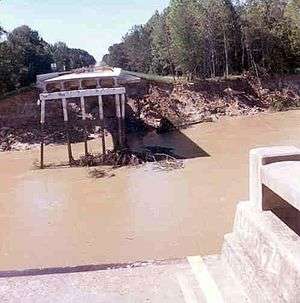
Mississippi Highway 33 bridge failure just north of Rosetta, Mississippi, caused by the April 1974 flood on the Homochitto River.
From north to south
Major intersections
| County | Location | mi | km | Destinations | Notes |
|---|---|---|---|---|---|
| Wilkinson | | Louisiana state line | |||
| Centreville | south end of MS 24 overlap | ||||
| Amite | Downtown Centreville (MS 946) | ||||
| | |||||
| Gloster | north end of MS 24 overlap | ||||
| Wilkinson | | ||||
| Franklin | | ||||
| Jefferson | | south end of MS 28 overlap | |||
| Fayette | Main Street - Fayette | former US 61 | |||
| | north end of MS 28 overlap | ||||
| 1.000 mi = 1.609 km; 1.000 km = 0.621 mi | |||||
References
- ↑ "Mississippi Public Roads Selected Statistics" (PDF). Mississippi Department of Transportation. 2008. Archived from the original (PDF) on 2010-12-03. Retrieved 2010-06-03.
This article is issued from
Wikipedia.
The text is licensed under Creative Commons - Attribution - Sharealike.
Additional terms may apply for the media files.