Magna Vista, Mississippi
| Magna Vista, Mississippi | |
|---|---|
| Ghost town | |
 Magna Vista  Magna Vista | |
| Coordinates: 32°39′29″N 91°03′42″W / 32.65806°N 91.06167°WCoordinates: 32°39′29″N 91°03′42″W / 32.65806°N 91.06167°W | |
| Country | United States |
| State | Mississippi |
| County | Issaquena |
| Elevation32 | 105 ft (32 m) |
| Time zone | UTC-6 (Central (CST)) |
| • Summer (DST) | UTC-5 (CDT) |
| GNIS feature ID | 692034[1] |
Magna Vista is a ghost town in Issaquena County, Mississippi.[1]
Magna Vista originated as a postal village located directly on the Mississippi River. It had a population of 50 in 1900.[2]
In 1934, the U.S. Army Corps of Engineers began construction of the Newman Cutoff, which created Chotard Lake and Albemarle Lake, both oxbow lakes, and removed Magna Vista from the contiguous Mississippi River.[3]
The place where Magna Vista was located is now directly on top of the Mississippi Levee. Nothing remains of the former settlement.
References
- 1 2 "Magna Vista". Geographic Names Information System. United States Geological Survey.
- ↑ Rowland, Dunbar (1907). Mississippi: Comprising Sketches of Counties, Towns, Events, Institutions, and Persons, Arranged in Cyclopedic Form. 2. Southern Historical Publishing Association. p. 163.
- ↑ Bragg, Marion (1977). "Historic Names and Places on the Lower Mississippi River" (PDF). Mississippi River Commission. Archived from the original (PDF) on 2013-02-24.
Municipalities and communities of Issaquena County, Mississippi, United States | ||
|---|---|---|
| Town | 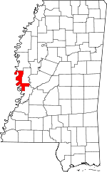 | |
| Unincorporated communities | ||
| Ghost towns | ||
This article is issued from
Wikipedia.
The text is licensed under Creative Commons - Attribution - Sharealike.
Additional terms may apply for the media files.