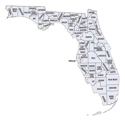
List of counties in Florida
| Counties of Florida | |
|---|---|
  | |
| Location | State of Florida |
| Number | 67 |
| Populations | 8,314 (Liberty) – 2,662,874 (Miami-Dade) |
| Areas |
240 square miles (620 km2) (Union) – 2,034 square miles (5,270 km2) (Palm Beach) |
| Government | County government |
| Subdivisions | Communities |
There are 67 counties in the state of Florida. It became a territory of the U.S. in 1821 with two counties complementing the provincial divisions retained as a Spanish territory: Escambia to the west and St. Johns to the east, divided by the Suwannee River. All of the other counties were apportioned from these two original counties. Florida became the 27th U.S. state in 1845, and its last county was created in 1925 with the formation of Gilchrist County from a segment of Alachua County.[1] Florida's counties are subdivisions of the state government. In 1968, counties gained the power to develop their own charters.[2] All but two of Florida's county seats are incorporated municipalities. The exceptions are Crawfordville, county seat of rural Wakulla County,[3] and East Naples, located outside Naples city limits in Collier County.
The names of Florida's counties reflect its diverse cultural heritage. Some are named for Confederate political leaders and Spanish explorers, marking the influence of Spanish sovereignty, while others are named for Spanish saints, Native American placenames used by the Spanish, and political leaders of the United States. Natural features of the region, including rivers, lakes, and flora, are also commonly used for county names. Florida has counties named for participants on both sides of Second Seminole War: Miami-Dade County is partially named for Francis L. Dade, a Major in the U.S. Army at the time; Osceola County is named for a Native American resistance leader during the war.[4]
Population figures are based on the 2010 United States Census. The population of Florida is 18,801,310, an increase of 17.6% from 2000. The average population of Florida's counties is 280,616; Miami-Dade County is the most populous (2,662,874) and Liberty County is the least (8,365). The average land area is 805 sq mi (2,085 km2). The largest county is Palm Beach County (2,034 sq mi, 5,268 km2) and the smallest is Union County (240 sq mi, 622 km2). The total area of the state is 65,795 sq miles; of this, the land area of the state constitutes 53,927 square miles (139,670 km2) while the water area constitutes 11,868 sq miles.[5][6]
The Federal Information Processing Standard (FIPS) is used by the U.S. government to uniquely identify counties, and is provided for each entry. These codes link to the United States Census Bureau's "quick facts" for each county. Florida's FIPS code of 12 is used to distinguish from counties in other states. For example, Alachua County's unique nationwide identifier is 12001.[7]
Counties
| County |
FIPS code[7] | County seat[8] | Established[4] | Formed from[9] | Etymology[4] | Density |
Population[10] | Area[5][8] | Map |
|---|---|---|---|---|---|---|---|---|---|
| Alachua County | 001 | Gainesville | 1824 | Duval and St. Johns | From a Seminole-Creek word meaning "jug", apparently in reference to the sinkholes common in the area[11] | 285.31 | 249,365 | 874 sq mi (2,264 km2) |  |
| Baker County | 003 | Macclenny | 1861 | New River | James McNair Baker (1821–1892), a Confederate senator and later a judge in the fourth judicial district | 46.42 | 27,154 | 585 sq mi (1,515 km2) |  |
| Bay County | 005 | Panama City | 1913 | Calhoun and Washington | St. Andrew's Bay, the central geographic feature of the county | 222.32 | 169,856 | 764 sq mi (1,979 km2) |  |
| Bradford County | 007 | Starke | 1858 | Columbia named New River until 1861 | Richard Bradford, the first officer from Florida to die in the Civil War; he was killed during the Battle of Santa Rosa Island | 96.43 | 28,255 | 293 sq mi (759 km2) |  |
| Brevard County | 009 | Titusville | 1844 | Hillsborough and Mosquito named St. Lucie until 1855[12] | Theodore Washington Brevard, early settler and later state comptroller from 1853 to 1861[12] | 533.95 | 543,566 | 1,018 sq mi (2,637 km2) | 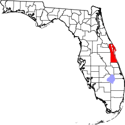 |
| Broward County | 011 | Fort Lauderdale | 1915 | Dade and Palm Beach | Napoleon Bonaparte Broward (1857–1910), 19th Governor of Florida from 1905 to 1909 | 1472.43 | 1,780,172 | 1,209 sq mi (3,131 km2) | 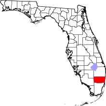 |
| Calhoun County | 013 | Blountstown | 1838 | Franklin, Jackson, and Washington | John C. Calhoun (1782–1850) leading Southern politician from South Carolina | 26.01 | 14,750 | 567 sq mi (1,469 km2) | 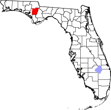 |
| Charlotte County | 015 | Punta Gorda | 1921 | DeSoto | Probably a corruption of the name of the Calusa, a group of Native Americans from the area | 231.28 | 160,511 | 694 sq mi (1,797 km2) |  |
| Citrus County | 017 | Inverness | 1887 | Hernando | The county's citrus trees | 239.78 | 140,031 | 584 sq mi (1,513 km2) | 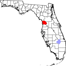 |
| Clay County | 019 | Green Cove Springs | 1858 | Duval | Henry Clay (1777–1852), Secretary of State from 1825 to 1829 under John Quincy Adams | 320.08 | 192,370 | 601 sq mi (1,557 km2) |  |
| Collier County | 021 | East Naples | 1923 | Lee | Barron Collier (1873–1939), an advertising entrepreneur who developed much of the land in southern Florida | 161.96 | 328,134 | 2,026 sq mi (5,247 km2) | 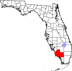 |
| Columbia County | 023 | Lake City | 1832 | Alachua | Christopher Columbus (c. 1451–1506), explorer of the Americas | 84.67 | 67,485 | 797 sq mi (2,064 km2) | 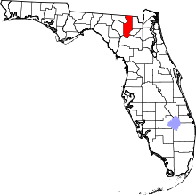 |
| DeSoto County | 027 | Arcadia | 1887 | Manatee | Hernando de Soto (c. 1496/1497–1542), a Spanish explorer and conquistador | 54.78 | 34,894 | 637 sq mi (1,650 km2) |  |
| Dixie County | 029 | Cross City | 1921 | Lafayette | Dixie, the common nickname for the Southern United States | 23.42 | 16,486 | 704 sq mi (1,823 km2) | 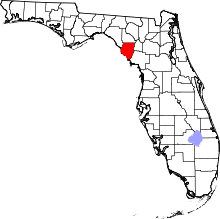 |
| Duval County | 031 | Jacksonville | 1822 | St. Johns | William Pope Duval (1784–1854), the first governor of the Florida Territory | 1124.95 | 937,934 | 774 sq mi (2,005 km2) | 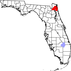 |
| Escambia County | 033 | Pensacola | 1821 | One of the two original counties | Disputed origin; possibly from the Native American word Shambia, meaning "clear water", or from Spanish word “cambiar”, meaning to barter | 450.47 | 299,114 | 664 sq mi (1,720 km2) |  |
| Flagler County | 035 | Bunnell | 1917 | St. Johns and Volusia | Henry Morrison Flagler (1830–1913), founder of the Florida East Coast Railway | 200.78 | 97,376 | 485 sq mi (1,256 km2) |  |
| Franklin County | 037 | Apalachicola | 1832 | Gadsden and Washington | Benjamin Franklin (1706–1790), one of the Founding Fathers of the United States of America | 21.72 | 11,596 | 534 sq mi (1,383 km2) |  |
| Gadsden County | 039 | Quincy | 1823 | Jackson | James Gadsden (1788–1858), American diplomat and namesake of the Gadsden Purchase | 89.44 | 46,151 | 516 sq mi (1,336 km2) | 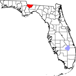 |
| Gilchrist County | 041 | Trenton | 1925 | Alachua | Albert W. Gilchrist (1858–1926), the 20th Governor of Florida | 48.72 | 17,004 | 349 sq mi (904 km2) | 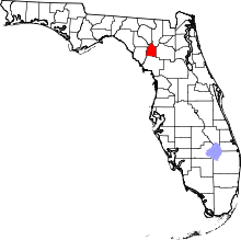 |
| Glades County | 043 | Moore Haven | 1921 | DeSoto | The Florida Everglades | 16.32 | 12,635 | 774 sq mi (2,005 km2) | 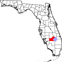 |
| Gulf County | 045 | Port St. Joe | 1925 | Calhoun | The Gulf of Mexico | 28.04 | 15,844 | 565 sq mi (1,463 km2) |  |
| Hamilton County | 047 | Jasper | 1827 | Jefferson | Alexander Hamilton (1757–1804), the first United States Secretary of the Treasury and a Founding Father | 28.49 | 14,671 | 515 sq mi (1,334 km2) | 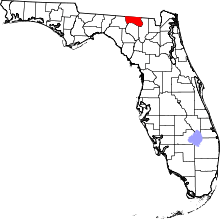 |
| Hardee County | 049 | Wauchula | 1921 | DeSoto | Cary A. Hardee (1876–1957), governor of Florida at the time of creation of Hardee County | 43.78 | 27,887 | 637 sq mi (1,650 km2) | 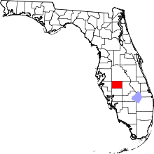 |
| Hendry County | 051 | LaBelle | 1923 | Lee | Francis A. Hendry (1833–1917), early Floridian pioneer and politician | 33.90 | 39,089 | 1,153 sq mi (2,986 km2) | 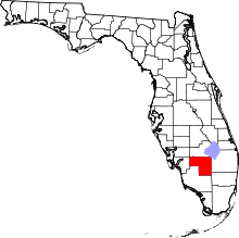 |
| Hernando County | 053 | Brooksville | 1843 | Alachua and Hillsborough named Benton from 1844 to 1850 | Hernando de Soto (c.1496/1497–1542), a Spanish explorer and conquistador | 362.12 | 173,094 | 478 sq mi (1,238 km2) |  |
| Highlands County | 055 | Sebring | 1921 | DeSoto | Named for the county's hilly terrain | 95.94 | 98,630 | 1,028 sq mi (2,663 km2) | 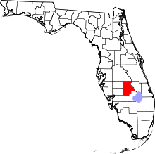 |
| Hillsborough County | 057 | Tampa | 1834 | Alachua | Wills Hill, Earl of Hillsborough (1718–1793), former Secretary of State for the Colonies | 1206.26 | 1,267,775 | 1,051 sq mi (2,722 km2) | 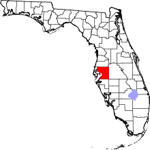 |
| Holmes County | 059 | Bonifay | 1848 | Jackson and Walton | Holmes Creek, which forms the eastern boundary of the county | 41.23 | 19,873 | 482 sq mi (1,248 km2) | 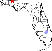 |
| Indian River County | 061 | Vero Beach | 1925 | St. Lucie | The Indian River Lagoon, which flows through the county | 276.13 | 138,894 | 503 sq mi (1,303 km2) | 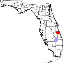 |
| Jackson County | 063 | Marianna | 1822 | Escambia | Andrew Jackson (1767–1845), the seventh President of the United States | 53.81 | 49,292 | 916 sq mi (2,372 km2) | 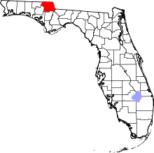 |
| Jefferson County | 065 | Monticello | 1827 | Leon | Thomas Jefferson (1743–1826), the third President of the United States and principal author of the Declaration of Independence | 24.51 | 14,658 | 598 sq mi (1,549 km2) |  |
| Lafayette County | 067 | Mayo | 1856 | Madison | Gilbert du Motier, marquis de La Fayette (1757–1834), French aristocrat and general in the American Revolutionary War | 16.47 | 8,942 | 543 sq mi (1,406 km2) |  |
| Lake County | 069 | Tavares | 1887 | Orange and Sumter | Named for the many lakes in the region | 315.86 | 301,019 | 953 sq mi (2,468 km2) | 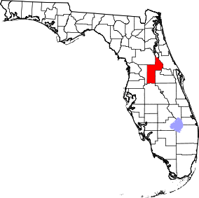 |
| Lee County | 071 | Fort Myers | 1887 | Monroe | Robert E. Lee (1807–1870), commander of the Confederate Army of Northern Virginia in the American Civil War | 785.24 | 631,330 | 804 sq mi (2,082 km2) |  |
| Leon County | 073 | Tallahassee | 1824 | Gadsden | Juan Ponce de León (1474–1521), Spanish explorer who named Florida | 416.75 | 277,971 | 667 sq mi (1,728 km2) | 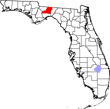 |
| Levy County | 075 | Bronson | 1845 | Alachua | David Levy Yulee (1810–1886), one of the state's original United States Senators | 35.92 | 40,156 | 1,118 sq mi (2,896 km2) | 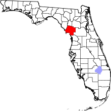 |
| Liberty County | 077 | Bristol | 1855 | Gadsden | The patriotic ideal of liberty | 9.94 | 8,314 | 836 sq mi (2,165 km2) | 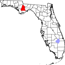 |
| Madison County | 079 | Madison | 1827 | Jefferson | James Madison (1751–1836), fourth President of the United States | 27.62 | 19,115 | 692 sq mi (1,792 km2) | 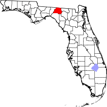 |
| Manatee County | 081 | Bradenton | 1855 | Hillsborough | The manatee, or sea cow, is native to Florida waters. | 441.49 | 327,142 | 741 sq mi (1,919 km2) | 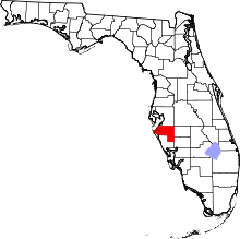 |
| Marion County | 083 | Ocala | 1844 | Alachua, Hillsborough, and Mosquito | Francis Marion (c. 1732–1795), military officer during the American Revolution | 210.59 | 332,529 | 1,579 sq mi (4,090 km2) | 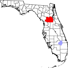 |
| Martin County | 085 | Stuart | 1925 | Palm Beach | John W. Martin (1884–1958), governor of Florida at time of creation of the county | 265.28 | 147,495 | 556 sq mi (1,440 km2) | 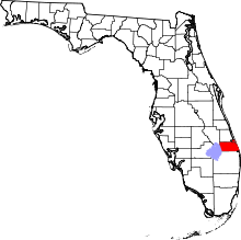 |
| Miami-Dade County | 086 | Miami | 1836 | Monroe named Dade until 1997 | City of Miami and Francis L. Dade (c. 1793–1835), Major in the United States Army during the Second Seminole War | 1313.50 | 2,662,874 | 1,946 sq mi (5,040 km2) | 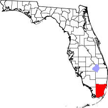 |
| Monroe County | 087 | Key West | 1823 | St. Johns | James Monroe (1758–1831), fifth President of the United States | 74.10 | 73,873 | 997 sq mi (2,582 km2) | 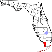 |
| Nassau County | 089 | Fernandina Beach | 1824 | Duval | Duchy of Nassau in Germany | 113.80 | 74,195 | 652 sq mi (1,689 km2) |  |
| Okaloosa County | 091 | Crestview | 1915 | Santa Rosa and Walton | A native word meaning "a pleasant place," "black water", or "beautiful place" | 196.03 | 183,482 | 936 sq mi (2,424 km2) | 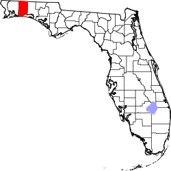 |
| Okeechobee County | 093 | Okeechobee | 1917 | Osceola and St. Lucie | Lake Okeechobee, which was in turn is from the Hitchiti words for "big water" | 51.86 | 40,140 | 774 sq mi (2,005 km2) | 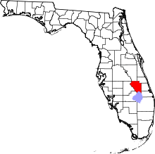 |
| Orange County | 095 | Orlando | 1824 | St. Johns named Mosquito until 1845 | The fruit that was the county's main product | 1287.56 | 1,169,107 | 908 sq mi (2,352 km2) | 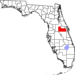 |
| Osceola County | 097 | Kissimmee | 1887 | Brevard and Orange | Osceola (1804–1838), a leader of the Seminole during the Second Seminole War | 208.90 | 276,163 | 1,322 sq mi (3,424 km2) | 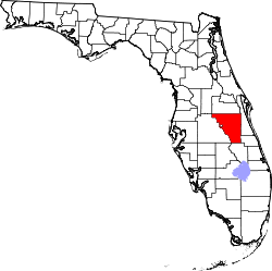 |
| Palm Beach County | 099 | West Palm Beach | 1909 | Dade | The county's large amounts of palm trees | 656.43 | 1,335,187 | 2,034 sq mi (5,268 km2) | 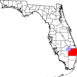 |
| Pasco County | 101 | Dade City | 1887 | Hernando | Samuel Pasco (1834–1917), United States Senator at the time of creation of the county | 626.12 | 466,457 | 745 sq mi (1,930 km2) | 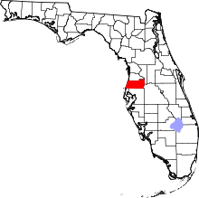 |
| Pinellas County | 103 | Clearwater | 1912 | Hillsborough | From the Spanish Punta Piñal, or "Point of Pines" | 3276.42 | 917,398 | 280 sq mi (725 km2) |  |
| Polk County | 105 | Bartow | 1861 | Brevard and Hillsborough | James K. Polk (1795–1849), the 11th President of the United States | 325.06 | 609,492 | 1,875 sq mi (4,856 km2) | 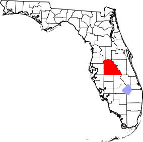 |
| Putnam County | 107 | Palatka | 1849 | Alachua and St. Johns | Benjamin A. Putnam (1801–1869), soldier during the Second Seminole War and Floridian legislator | 102.55 | 74,041 | 722 sq mi (1,870 km2) |  |
| St. Johns County | 109 | St. Augustine | 1821 | One of the two original counties | Name derived from the St. Johns River, which in turn derives its name from San Juan del Puerto | 321.55 | 195,823 | 609 sq mi (1,577 km2) |  |
| St. Lucie County | 111 | Fort Pierce | 1905 | Brevard | Saint Lucy (283–304), the Christian martyr | 490.17 | 280,379 | 572 sq mi (1,481 km2) | 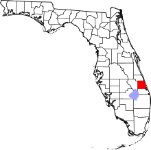 |
| Santa Rosa County | 113 | Milton | 1842 | Escambia | Santa Rosa Island, which is in turn named for Saint Rosa de Viterbo (1235–1252), a saint born in Viterbo, Italy | 151.68 | 154,104 | 1,016 sq mi (2,631 km2) | 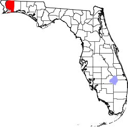 |
| Sarasota County | 115 | Sarasota | 1921 | Manatee | Native American word, of uncertain meaning, for the area | 668.20 | 382,213 | 572 sq mi (1,481 km2) |  |
| Seminole County | 117 | Sanford | 1913 | Orange | The Seminole Native American tribe | 1380.10 | 425,071 | 308 sq mi (798 km2) | 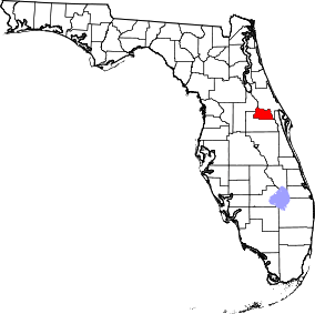 |
| Sumter County | 119 | Bushnell | 1853 | Marion | Thomas Sumter (1734–1832), general in the American Revolution | 179.04 | 97,756 | 546 sq mi (1,414 km2) | 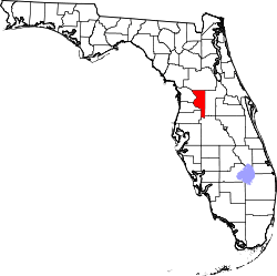 |
| Suwannee County | 121 | Live Oak | 1858 | Columbia | The Suwannee River, a 266-mile long river in northern Florida | 61.01 | 41,972 | 688 sq mi (1,782 km2) | 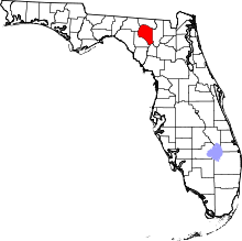 |
| Taylor County | 123 | Perry | 1856 | Madison | Zachary Taylor (1784–1850), 12th President of the United States | 21.78 | 22,691 | 1,042 sq mi (2,699 km2) | 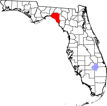 |
| Union County | 125 | Lake Butler | 1921 | Bradford | Named for the area's residents united desire to split into a separate county | 64.12 | 15,388 | 240 sq mi (622 km2) |  |
| Volusia County | 127 | DeLand | 1854 | Orange | The port of Volusia, whose etymology is uncertain; possibly derived from the Native American word for "Land of the Euchees," the term for the area's native inhabitants | 447.38 | 494,804 | 1,106 sq mi (2,865 km2) | 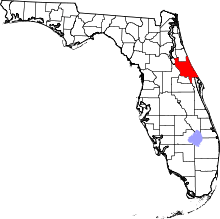 |
| Wakulla County | 129 | Crawfordville | 1843 | Leon | The Wakulla River, itself named for a Spanish corruption of a Timucuan word used to describe the body of water, but that is of uncertain meaning | 51.03 | 30,978 | 607 sq mi (1,572 km2) | 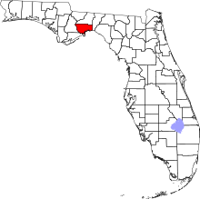 |
| Walton County | 131 | DeFuniak Springs | 1824 | Escambia and Jackson | George Walton, first Secretary of Florida Territory | 52.73 | 55,793 | 1,058 sq mi (2,740 km2) | 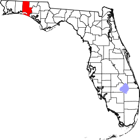 |
| Washington County | 133 | Chipley | 1825 | Jackson and Walton | George Washington (1732–1799), first President of the United States | 42.99 | 24,935 | 580 sq mi (1,502 km2) | 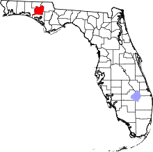 |
Former counties
Fayette County was created in 1832 from the portion of Jackson County east of the Chipola River, with county seat at Ochesee (now in Calhoun County east of Altha).[13][14] In 1834 it was merged back into Jackson County.[15]
Renamed counties
Five counties in Florida have been renamed. Most renamings occurred between 1845 and 1861, during the first sixteen years of Florida's statehood. One occurred in 1997, when Dade County changed its name to Miami-Dade County.
| County[4] | Dates[4] | Etymology[4] | Fate[4] |
|---|---|---|---|
| Benton County | 1844–1850 | Thomas Benton (1782–1858), U.S. Senator from Missouri who supported the Armed Occupation Act of 1842 that many Floridians wanted in order to evict Native Americans | Original name of county was Hernando County, and the name was changed back to that in 1850 |
| Dade County | 1836–1997 | Francis L. Dade (c. 1793–1835), Major in the United States Army during the Second Seminole War | Changed to Miami-Dade County in 1997, in order to benefit from the City of Miami's internationally-recognizable name |
| Mosquito County | 1824–1845 | Taken from the name the Spanish had given the entire coast, "Los Mosquitos" | Mosquito had already repeatedly ceded land to other counties by 1845, when it was renamed Orange County |
| New River County | 1858–1861 | The New River | Renamed to Bradford County in 1861 |
| St. Lucie County | 1844–1855 | Saint Lucy (283–304), the Christian martyr | Renamed Brevard County in 1855 |
Proposed counties
Two counties were proposed in Florida's state legislature, but neither actually became counties. A bill was passed by the legislature to create Bloxham County, but residents did not vote to approve it. See Leigh Read County, Florida for the events surrounding the proposed county.
| County[4] | Proposal date[4] | Etymology[4] | Notes |
|---|---|---|---|
| Bloxham County | 1915[16] | William D. Bloxham (1835–1911), 13th and 17th Governor of Florida | county seat at Williston |
| Leigh Read County | 1842 | Leigh Read, legislator | proposed renaming of Mosquito County |
| Miami County[17] | 1947 | City of Miami | consolidated city-county |
| Ocean County | 1991 | Atlantic Ocean | Jacksonville Beaches |
See also
Further reading
- Utley, Geo. B. (1908). "Origin of the County Names in Florida". Florida Historical Society Quarterly. 1 (3). pp. 29–35. Retrieved May 25, 2018.
References
- Specific
- ↑ "A Guide to Alachua County's History". Alachua County Florida. Archived from the original on October 6, 2006. Retrieved March 24, 2010.
- ↑ "About Florida's Counties". Florida Association of Counties. Archived from the original on October 4, 2012. Retrieved January 20, 2010.
- ↑ "Demographics". Wakulla County Chamber of Commerce. Retrieved 2012-01-30.
- 1 2 3 4 5 6 7 8 9 10 "Florida County Maps". Florida Center for Instructional Technology – University of South Florida. Retrieved January 16, 2010.
- 1 2 "Florida QuickFacts". U.S. Census Bureau. Archived from the original on July 2, 2013. Retrieved April 23, 2008. (2008 Census estimates)
- ↑ "Population Estimates". U.S. Census Bureau. December 2009. Archived from the original on February 23, 2010. Retrieved March 13, 2010. (updated 2008 population estimate)
- 1 2 "United States Environmental Protection Agency (EPA) County FIPS Code Listing". United States Environmental Protection Agency. Archived from the original on October 8, 2012. Retrieved April 24, 2008.
- 1 2 "NACo – Find a county". National Association of Counties. Archived from the original on October 25, 2007. Retrieved April 24, 2008.
- ↑ Newberry Library, Atlas of Historical County Boundaries: Florida, accessed May 2014
- ↑ "Florida QuickFacts from the US Census Bureau". United States Census Bureau. Archived from the original on August 14, 2012. Retrieved August 19, 2012.
- ↑ Morris, Allen, Florida Place Names
- 1 2 Eriksen, John M., Brevard County, Florida...A Short History to 1955
- ↑ "An Act to organise a county to be called the County of Fayette". Act No. 53 of 1832.
- ↑ "An Act, more accurately to define the boundaries of Fayette County, and for other purposes". Act No. 31 (Chapter 688) of 1833.
- ↑ "An Act to repeal certain acts organizing the County of Fayette". Act No. 26 (Chapter 765) of 1834.
- ↑ "An Act Providing for the Creation of Bloxham County in the State of Florida, and for the Organization and the Government Thereof". Act No. 130 (Chapter 6936) of 1915.
- ↑ "An Act Providing the Manner, Method and Means of the Election and Creation of a Charter Board in the Territory now Comprising Dade County; Providing for the Drafting and Adopting of the Charter Prepared by Said Board for Said Territory; Providing for the Election of Commissioners of a New Political Subdivision in the Territory now Comprising Dade County to be Known as the County of Miami; Providing the Effective Date of Said Charter and the Time the Board of Commissioners Shall Take Office; and Providing that This Act Shall not Become Effective Until the Joint Resolution No. 407 has Been Approved by the Qualified Electors of Dade County and of the State of Florida as a Whole". Act No. 853 (Chapter 24467) of 1947.
- General
- Atlas of Florida, revised edition. Edward A. Fernald & Elizabeth D. Purdum, editors (University Press of Florida, 1996). "Evolution of Counties", pp. 98–99.