Indian River County, Florida
| Indian River County, Florida | ||
|---|---|---|
.JPG) Indian River County Courthouse in Vero Beach | ||
| ||
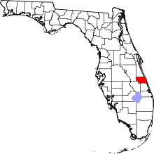 Location in the U.S. state of Florida | ||
 Florida's location in the U.S. | ||
| Founded | May 30, 1925 | |
| Named for | Indian River Lagoon | |
| Seat | Vero Beach | |
| Area | ||
| • Total | 617 sq mi (1,598 km2) | |
| • Land | 503 sq mi (1,303 km2) | |
| • Water | 114 sq mi (295 km2), 18.5% | |
| Population (est.) | ||
| • (2017) | 154,383[1] | |
| • Density | 307/sq mi (119/km2) | |
| Congressional district | 8th | |
| Time zone | Eastern: UTC−5/−4 | |
| Website |
www | |
Indian River County is a county located in the Treasure Coast region of the U.S. state of Florida. As of the 2010 census, the population was 138,028.[2] Its seat is Vero Beach.[3] It is Florida's 7th richest county and in 2000 was the 87th richest county in the U.S. by per capita income.[4]
Indian River County comprises the Sebastian-Vero Beach, Florida Metropolitan Statistical Area, which is included in the Miami-Fort Lauderdale-Port St. Lucie, Florida Combined Statistical Area.
History
Prior to 1821 the area of Indian River County was part of the Spanish colony of East Florida. In 1822 this area became part of St. Johns County, in 1824 it became part of Mosquito County (original name of Orange County).
The Second Seminole War was fought in 1835 and from 1838 to 1839. Fort Vinton was built for this purpose near where the intersection of Florida State Road 60 near 122nd avenue lies today.[5]
In 1844 the county's portion of Mosquito County became part of newly created St. Lucia County. In 1855 St. Lucia County was renamed Brevard County. In 1905 St. Lucie County was formed from the southern portion of Brevard County; in 1925 Indian River County was formed from the northern portion of St. Lucie County.[6] It was named for the Indian River Lagoon, which runs through the eastern portion of the county.
Geography
According to the U.S. Census Bureau, the county has a total area of 617 square miles (1,600 km2), of which 503 square miles (1,300 km2) is land and 114 square miles (300 km2) (18.5%) is water.[7]
Adjacent counties
- Brevard County - north
- St. Lucie County - south
- Okeechobee County - southwest
- Osceola County - northwest
National protected areas
Demographics
| Historical population | |||
|---|---|---|---|
| Census | Pop. | %± | |
| 1930 | 6,724 | — | |
| 1940 | 8,957 | 33.2% | |
| 1950 | 11,872 | 32.5% | |
| 1960 | 25,309 | 113.2% | |
| 1970 | 35,992 | 42.2% | |
| 1980 | 59,896 | 66.4% | |
| 1990 | 90,208 | 50.6% | |
| 2000 | 112,947 | 25.2% | |
| 2010 | 138,028 | 22.2% | |
| Est. 2017 | 154,383 | [8] | 11.8% |
| U.S. Decennial Census[9] 1790-1960[10] 1900-1990[11] 1990-2000[12] 2010-2015[2] | |||
As of the census[13] of 2000, there were 112,947 people, 49,137 households, and 32,725 families residing in the county. The population density was 224 people per square mile (87/km²). There were 57,902 housing units at an average density of 115 per square mile (44/km²). The racial makeup of the county was 87.43% White, 8.19% Black or African American, 0.25% Native American, 0.74% Asian, 0.03% Pacific Islander, 2.15% from other races, and 1.21% from two or more races. 6.53% of the population were Hispanic or Latino of any race.
There were 49,137 households out of which 21.70% had children under the age of 18 living with them, 54.50% were married couples living together, 8.90% had a female householder with no husband present, and 33.40% were non-families. 28.20% of all households were made up of individuals and 16.10% had someone living alone who was 65 years of age or older. The average household size was 2.25 and the average family size was 2.72.
In the county, the population was spread out with 19.20% under the age of 18, 6.00% from 18 to 24, 22.30% from 25 to 44, 23.30% from 45 to 64, and 29.20% who were 65 years of age or older. The median age was 47 years. For every 100 females there were 93.70 males. For every 100 females age 18 and over, there were 90.80 males.
The median income for a household in the county was $39,635, and the median income for a family was $46,385. Males had a median income of $30,870 versus $23,379 for females. The per capita income for the county was $27,227. About 6.30% of families and 9.30% of the population were below the poverty line, including 13.60% of those under age 18 and 5.70% of those age 65 or over.
Transportation
Airports
- New Hibiscus Airpark
- Sebastian Municipal Airport
- Vero Beach Regional Airport
Bus systems
GoLine is Indian River County's main method of public transportation. The program was introduced in 1994 to provide an alternative option to driving. Due to County population increases in the early and mid 2000's, Indian River County devised a series of bus routes from Barefoot Bay in southern Brevard County to the south end of Vero Beach. In 2006, GoLine (formerly known as Indian River Transit) was introduced with more stops along and through the Treasure Coast. By 2010, the GoLine system had a total of 14 stops with an additional four stops planned for 2011/2012. Riders pay no fare or fee to board the bus. In 2010 the buses operated between 8:00 A.M. and 5:00 P.M. weekdays and from 9:00 A.M. to 3:00 P.M. on Saturdays. Some routes have extended operating hours depending on location.[14][15]
Train
There is planning underway for an Amtrak station in Vero Beach.[16][17]
Economy
It is home to general aviation manufacturer Piper Aircraft and Velocity Aircraft , CVS distribution Center. The county is headquarters for the Indian River Citrus, locally harvested.[18]
Libraries
- Indian River County Main Library, in Vero Beach
- North Indian River County Library, in Sebastian
- The Brackett Library, at the Indian River State College Mueller Campus, in Vero Beach
Education
Indian River County School District operates public schools. Public high schools include:
- Freshman Learning Center (VBHS)
- Indian River Charter High School
- Sebastian River High School
- Vero Beach High School
Private schools
- Glendale Christian School
- Indian River Christian School
- Master's Academy
- St. Edwards Lower School
- St. Edwards Upper School
- St. Helen Catholic School
- Tabernacle Baptist School
- The Willow School
- SunCoast Primary School
Colleges and universities
- Barry University Vero Beach Campus
- Indian River State College Mueller Center
- Indian River State College Sebastian Campus
Elections
Indian River County lies at the northern end of a belt stretching to Collier County in the southwest that was the first part of Florida to politically distance itself from the "Solid South": the last Democrat to win a majority in the county was Franklin D. Roosevelt in 1944.[19] In 1992, indeed, Ross Perot came second, fifteen votes ahead of President-elect Bill Clinton, this being one of only three Florida counties where he did so.[20]
| Year | Republican | Democratic | Other |
|---|---|---|---|
| 2016 | 60.20% 48,620 | 35.96% 29,043 | 3.85% 3,106 |
| 2012 | 60.70% 43,450 | 38.41% 27,492 | 0.89% 638 |
| 2008 | 56.74% 40,176 | 41.96% 29,710 | 1.29% 916 |
| 2004 | 60.15% 36,938 | 39.01% 23,956 | 0.85% 520 |
| 2000 | 57.71% 28,639 | 39.84% 19,769 | 2.45% 1,219 |
| 1996 | 51.66% 22,714 | 37.24% 16,375 | 11.11% 4,883 |
| 1992 | 43.54% 19,140 | 28.12% 12,360 | 28.35% 12,462 |
| 1988 | 69.71% 24,630 | 29.58% 10,451 | 0.71% 252 |
| 1984 | 73.08% 23,716 | 26.92% 8,736 | |
| 1980 | 62.98% 15,568 | 31.39% 7,759 | 5.62% 1,390 |
| 1976 | 52.63% 9,818 | 45.63% 8,512 | 1.74% 324 |
| 1972 | 77.85% 11,741 | 21.99% 3,316 | 0.17% 25 |
| 1968 | 51.25% 6,518 | 24.99% 3,179 | 23.76% 3,022 |
| 1964 | 54.72% 6,191 | 45.28% 5,122 | |
| 1960 | 61.05% 4,656 | 38.95% 2,970 | |
| 1956 | 70.49% 4,059 | 29.51% 1,699 | |
| 1952 | 65.94% 3,055 | 34.06% 1,578 | |
| 1948 | 46.32% 1,134 | 43.10% 1,055 | 10.58% 259 |
| 1944 | 37.01% 759 | 62.99% 1,292 | |
| 1940 | 37.81% 904 | 62.19% 1,487 | |
| 1936 | 29.52% 532 | 70.48% 1,270 | |
| 1932 | 25.43% 446 | 74.57% 1,308 | |
| 1928 | 55.61% 847 | 43.14% 657 | 1.25% 19 |
Communities
Cities
Towns
Census-designated places
- Florida Ridge
- Gifford
- Roseland
- South Beach
- Vero Beach South
- Wabasso
- Wabasso Beach
- West Vero Corridor
- Windsor (formerly North Beach)
- Winter Beach
Other unincorporated communities
- Blue Cypress Village
- Cummings
- Nevins
- Oslo
- Riomar
- Royal Poinciana Park
- Vero Lake Estates
See also
References
- ↑ https://www.census.gov/quickfacts/fact/table/indianrivercountyflorida/PST045217
- 1 2 "State & County QuickFacts". United States Census Bureau. Retrieved February 14, 2014.
- ↑ "Find a County". National Association of Counties. Archived from the original on May 31, 2011. Retrieved 2011-06-07.
- ↑ Florida locations by per capita income
- ↑ Brotemarkle, Ben (August 23, 2017). "Florida couple documents Seminole Indian Wars". Florida Today. Melbourne, Florida. pp. 5A. Retrieved August 30, 2017.
- ↑ According to the Historical Records and State Archives Surveys, published by Florida Works Progress Administration, and available in the digital historical maps of Florida section of the UF library. And the Indian River County Historian, Ruth Stanbridge
- ↑ "US Gazetteer files: 2010, 2000, and 1990". United States Census Bureau. 2011-02-12. Retrieved 2011-04-23.
- ↑ "Population and Housing Unit Estimates". Retrieved June 9, 2017.
- ↑ "U.S. Decennial Census". United States Census Bureau. Archived from the original on May 12, 2015. Retrieved June 14, 2014.
- ↑ "Historical Census Browser". University of Virginia Library. Retrieved June 14, 2014.
- ↑ "Population of Counties by Decennial Census: 1900 to 1990". United States Census Bureau. Retrieved June 14, 2014.
- ↑ "Census 2000 PHC-T-4. Ranking Tables for Counties: 1990 and 2000" (PDF). United States Census Bureau. Retrieved June 14, 2014.
- ↑ "American FactFinder". United States Census Bureau. Archived from the original on September 11, 2013. Retrieved 2011-05-14.
- ↑ "Indian River Transit - GoLine Information". GoLineIRT.com. Retrieved 2012-12-18.
- ↑ http://www.golineirt.com/GoLineGuide.pdf
- ↑ http://www.irmpo.com/Documents/Amtrak.pdf
- ↑ "Home". irmpo.com. 2012-07-01. Retrieved 2012-12-18.
- ↑ "Indian River Citrus". Indian-river.fl.us. Retrieved 2012-12-18.
- ↑ Sullivan, Robert David; ‘How the Red and Blue Map Evolved Over the Past Century’; America Magazine in The National Catholic Review; June 29, 2016
- ↑ David Leip's Atlas of U.S. Presidential Elections; 1992 Presidential General Election Data Graphs – Florida by County
External links
| Wikimedia Commons has media related to Indian River County, Florida. |
- Economic Development and Tourism
Governmental
- Board of County Commissioners
- Constitutional Officers
- School District
- Multi-county Districts
- Judicial
Places adjacent to Indian River County, Florida | ||||||||||
|---|---|---|---|---|---|---|---|---|---|---|
| ||||||||||
Municipalities and communities of Indian River County, Florida, United States | ||
|---|---|---|
| Cities | | |
| Towns | ||
| CDPs | ||
| Unincorporated communities | ||
