Collier County, Florida
| Collier County, Florida | |||
|---|---|---|---|
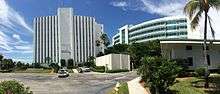
.JPG) The Collier County courthouse in April 2010 | |||
| |||
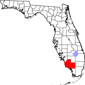 Location in the U.S. state of Florida | |||
 Florida's location in the U.S. | |||
| Founded | May 8, 1923 | ||
| Named for | Barron Collier | ||
| Seat | East Naples | ||
| Largest city | Naples | ||
| Area | |||
| • Total | 2,305 sq mi (5,970 km2) | ||
| • Land | 1,998 sq mi (5,175 km2) | ||
| • Water | 307 sq mi (795 km2), 13.3% | ||
| Population (est.) | |||
| • (2017) | 372,880[1] | ||
| • Density | 187/sq mi (72/km2) | ||
| Congressional districts | 19th, 25th | ||
| Time zone | Eastern: UTC−5/−4 | ||
| Website |
www | ||
Collier County is a county in the U.S. state of Florida. As of the 2010 census, the population was 321,520.[2] Its county seat is East Naples,[3] where the county offices were moved from Everglades City in 1962.
Collier County comprises the Naples-Immokalee-Marco Island, FL Metropolitan Statistical Area, which is included in the Cape Coral-Fort Myers-Naples, FL Combined Statistical Area.
History
Collier County was created in 1923 from Lee County. It was named for Barron Collier, a New York City advertising mogul and real estate developer who had moved to Southwest Florida and established himself as a prominent landowner. He agreed to build the Tamiami Trail for what was then Lee County (comprising today's Charlotte, Collier, Glades, Hendry, and Lee Counties) in exchange for favorable consideration with the state legislature to have a county named for him. After Collier County was named, Collier was quoted as saying: "When I first came here on holiday with Juliet, I never expected that I would buy a whole region of it, nor did I expect to pay for the new Tamiami Trail, or half the things I've done. But I really didn't expect to have a whole county named after me."[4]
Geography
According to the U.S. Census Bureau, the county has a total area of 2,305 square miles (5,970 km2), of which 1,998 square miles (5,170 km2) is land and 307 square miles (800 km2) (13.3%) is water.[5] It is the largest county in Florida by land area and fourth-largest by total area. Virtually the entire southeastern portion of the county lies within the Big Cypress National Preserve. The northernmost portion of Everglades National Park extends into the southern coastal part of the county.
Adjacent counties
Collier County is located at the southern end of Florida's Gulf Coast, and bounded by:
- Hendry County - north
- Broward County - east
- Miami-Dade County - southeast
- Monroe County - south
- Lee County - northwest
National protected areas
Transportation
Airports
Major highways
Demographics
| Historical population | |||
|---|---|---|---|
| Census | Pop. | %± | |
| 1930 | 2,883 | — | |
| 1940 | 5,102 | 77.0% | |
| 1950 | 6,488 | 27.2% | |
| 1960 | 15,753 | 142.8% | |
| 1970 | 38,040 | 141.5% | |
| 1980 | 85,971 | 126.0% | |
| 1990 | 152,099 | 76.9% | |
| 2000 | 251,377 | 65.3% | |
| 2010 | 321,520 | 27.9% | |
| Est. 2017 | 372,880 | [6] | 16.0% |
| U.S. Decennial Census[7] 1790-1960[8] 1900-1990[9] 1990-2000[10] 2010-2015[2] | |||
As of the census[11] of 2000, there were 251,377 people, 102,973 households, and 71,257 families residing in the county. The population density was 124 people per square mile (48/km²). There were 144,536 housing units at an average density of 71 per square mile (28/km²).
As of 2000, 86.06% of the population was White, 4.54% was Black or African American, 0.29% Native American, 0.62% Asian, 0.06% Pacific Islander, 6.19% from other races, and 2.23% from two or more races. Hispanic or Latino individuals (of any race) accounted for 19.61%. Languages spoken: 75.3% spoke English, 17.8% Spanish, 2.3% French Creole and 1.2% German as their first language.
In 2000 there were 102,973 households out of which 22.70% had children under the age of 18 living with them, 58.10% were married couples living together, 7.20% had a female householder with no husband present, and 30.80% were non-families. 24.50% of all households were made up of individuals and 11.90% had someone living alone who was 65 years of age or older. The average household size was 2.39 and the average family size was 2.79.
The county's population distribution by age was spread out but older than the U.S. as a whole, with 19.90% under the age of 18, 6.60% from 18 to 24, 24.60% from 25 to 44, 24.50% from 45 to 64, and 24.50% who were 65 years of age or older. The median age was 44.1 years. For every 100 females there were 100.30 males. For every 100 females age 18 and over, there were 99.20 males.
The median income for a household in the county was $48,289, and the median income for a family was $54,816. Males had a median income of $32,639 versus $26,371 for females. The per capita income for the county was $31,195. About 6.60% of families and 10.30% of the population were below the poverty line, including 16.20% of those under age 18 and 4.30% of those age 65 or over.
The county continues to experience significant growth and is becoming increasingly diverse. As of the 2010 census, the county's population had increased to 321,520, an increase of 27.9% over the 2000 census. As of 2012, the United States Census estimates the county's population at 332,427, an increase of 3.4% since the 2010 census. As of the 2010 census, 65.7% of the population was non-Hispanic whites, 25.9% was Latino or Hispanic, 6.6% was African-American and 1.1% was Asian.[12] As of the 2010 census, the greatest source of population growth in the county since the 2000 census came from the Latino or Hispanic population which grew from 49,296 (19.6% of the total population) to 83,177 (25.9% of the total population). In terms of ancestry, 37.9% were English, 9.9% were Irish, 9.1% were "American", 3.2% were Italian and 3.1% were German.[13]
Education
The county's public schools are operated by the District School Board of Collier County.
Public library
The Collier County Public Library system consists of ten locations servicing the entire county. All locations offer public internet stations, printing, photocopying, free Wi-Fi, and 24/7 dropboxes for book and video returns.[14]
Politics
Voter Registration
According to the Secretary of State's office, Republicans compose a majority of registered voters in Collier County. It is also one of the handful of counties where independents outnumber Democrats among registrants. The county is part of a long-established Republican stronghold in southwestern coastal Florida: the last Democrat to win the county being Adlai Stevenson II in 1952.[15]
All voter information is as of June 22, 2018 and provided by Collier County Supervisor of Elections Office:[16]
Statewide Elections
| Year | Republican | Democratic | Third parties |
|---|---|---|---|
| 2016 | 61.11% 105,423 | 35.41% 61,085 | 3.48% 6,002 |
| 2012 | 64.64% 96,520 | 34.62% 51,698 | 0.74% 1,106 |
| 2008 | 60.84% 86,379 | 38.35% 54,450 | 0.82% 1,159 |
| 2004 | 64.99% 83,631 | 34.11% 43,892 | 0.90% 1,160 |
| 2000 | 65.58% 60,467 | 32.47% 29,939 | 1.94% 1,796 |
| 1996 | 58.74% 42,593 | 31.97% 23,185 | 9.30% 6,739 |
| 1992 | 53.44% 38,448 | 26.13% 18,796 | 20.43% 14,700 |
| 1988 | 74.87% 38,920 | 24.57% 12,769 | 0.56% 291 |
| 1984 | 78.75% 33,619 | 21.24% 9,067 | 0.01% 5 |
| 1980 | 71.10% 23,900 | 23.02% 7,739 | 5.87% 1,974 |
| 1976 | 61.76% 14,643 | 36.96% 8,764 | 1.28% 303 |
| 1972 | 80.63% 13,501 | 19.12% 3,201 | 0.25% 42 |
| 1968 | 50.85% 5,362 | 21.15% 2,230 | 28.00% 2,952 |
| 1964 | 55.45% 3,581 | 44.55% 2,877 | |
| 1960 | 60.74% 2,708 | 39.26% 1,750 | |
| 1956 | 59.73% 1,934 | 40.27% 1,304 | |
| 1952 | 49.59% 1,086 | 50.41% 1,104 | |
| 1948 | 28.07% 247 | 41.14% 362 | 30.79% 271 |
| 1944 | 21.95% 180 | 78.05% 640 | |
| 1940 | 16.17% 156 | 83.83% 809 | |
| 1936 | 8.89% 88 | 91.11% 902 | |
| 1932 | 8.03% 37 | 91.97% 424 | |
| 1928 | 37.01% 151 | 62.75% 256 | 0.25% 1 |
| 1924 | 8.33% 15 | 82.22% 148 | 9.45% 17 |
| Year | Republican | Democratic | Third parties |
|---|---|---|---|
| 2014 | 66.31% 75,337 | 31.05% 35,281 | 2.64% 3,002 |
| 2010 | 65.12% 66,960 | 32.49% 33,408 | 2.39% 2,465 |
| 2006 | 68.80% 59,821 | 29.10% 25,303 | 2.10% 1,822 |
| 2002 | 73.74% 61,555 | 25.44% 21,237 | 0.82% 687 |
| 1998 | 71.06% 41,688 | 28.94% 16,981 | 0.00% 1 |
| 1994 | 61.40% 36,370 | 38.60% 22,860 |
Communities
Cities
Census-designated places
Other unincorporated communities
Invasive snake issues
Collier is located in the center of Florida's invasive snake epidemic. A three-month effort at the beginning of 2016 netted over one ton of captured snakes, including a Florida record for largest male Burmese python, measuring 16 feet and weighing 140 pounds.[18][19][20]
In popular culture
Collier County was featured in Ace Ventura: Pet Detective as the home of fictional athlete Ray Finkle, described in the film as "the first and only professional athlete to come out of Collier County." Ace visits Collier to find Ray's family.
It was also shown in the Showtime series Dexter at the rest stop meeting between Dexter and the Trinity Killer.
See also
References
- ↑ https://www.census.gov/quickfacts/fact/table/colliercountyflorida/PST045217
- 1 2 "State & County QuickFacts". United States Census Bureau. Retrieved February 12, 2014.
- ↑ "Find a County". National Association of Counties. Archived from the original on May 31, 2011. Retrieved June 7, 2011.
- ↑ Clark, James C. (2014). A Concise History of Florida. Arcadia. p. 150.
- ↑ "US Gazetteer files: 2010, 2000, and 1990". United States Census Bureau. February 12, 2011. Retrieved April 23, 2011.
- ↑ "Population and Housing Unit Estimates". Retrieved June 9, 2017.
- ↑ "U.S. Decennial Census". United States Census Bureau. Archived from the original on May 12, 2015. Retrieved June 13, 2014.
- ↑ "Historical Census Browser". University of Virginia Library. Retrieved June 13, 2014.
- ↑ "Population of Counties by Decennial Census: 1900 to 1990". United States Census Bureau. Retrieved June 13, 2014.
- ↑ "Census 2000 PHC-T-4. Ranking Tables for Counties: 1990 and 2000" (PDF). United States Census Bureau. Retrieved June 13, 2014.
- ↑ "American FactFinder". United States Census Bureau. Archived from the original on September 11, 2013. Retrieved May 14, 2011.
- ↑ Bureau, U.S. Census. "American FactFinder - Results". factfinder2.census.gov.
- ↑ https://www.colliercountyfl.gov/your-government/divisions-a-e/comprehensive-planning/population-and-demographics
- ↑ "Locations, hours, maps". Collier County Public Library. Retrieved April 22, 2016.
- ↑ Sullivan, Robert David; ‘How the Red and Blue Map Evolved Over the Past Century’; America Magazine in The National Catholic Review; June 29, 2016
- ↑ "Collier County Supervisor of Elections". Retrieved June 22, 2018.
- ↑ Leip, David. "Dave Leip's Atlas of U.S. Presidential Elections". uselectionatlas.org.
- ↑ "A ton of Burmese pythons removed in 90 days". March 17, 2016.
- ↑ "South Florida has pythons by the ton, literally".
- ↑ "South Florida has pythons by the ton, literally".
External links
| Wikimedia Commons has media related to Collier County, Florida. |
Government links/Constitutional offices
- Collier County official website / Board of County Commissioners official website
- Collier County Supervisor of Elections
- Collier County Property Appraiser
- Collier County Sheriff's Office
- Collier County Tax Collector
- Collier County Public Library
Special districts
Judicial branch
Recycling Center
Tourism links
Places adjacent to Collier County, Florida | ||||||||||
|---|---|---|---|---|---|---|---|---|---|---|
| ||||||||||
Municipalities and communities of Collier County, Florida, United States | ||
|---|---|---|
| Cities | | |
| CDPs | ||
| Unincorporated communities | ||
