Highlands County, Florida
| Highlands County, Florida | ||
|---|---|---|
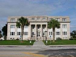 Highlands County Courthouse | ||
| ||
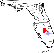 Location in the U.S. state of Florida | ||
 Florida's location in the U.S. | ||
| Founded | April 23, 1921 | |
| Named for | county's terrain | |
| Seat | Sebring | |
| Largest city | Sebring | |
| Area | ||
| • Total | 1,106 sq mi (2,865 km2) | |
| • Land | 1,017 sq mi (2,634 km2) | |
| • Water | 89 sq mi (231 km2), 8.1% | |
| Population (est.) | ||
| • (2017) | 102,883[1] | |
| • Density | 101/sq mi (39/km2) | |
| Congressional district | 17th | |
| Time zone | Eastern: UTC−5/−4 | |
| Website |
www | |
Highlands County is a county located in the U.S. state of Florida. As of the 2010 census, the population was 98,786.[2] Its county seat is Sebring.[3]
Highlands County comprises the Sebring, FL Metropolitan Statistical Area.
History
Highlands County was created in 1921 along with Charlotte, Glades, and Hardee, when they were separated from DeSoto County. Highlands was named for the terrain of the county. Highlands County boasted the fifth-oldest population in America in 2012.
Geography
According to the U.S. Census Bureau, the county has a total area of 1,106 square miles (2,860 km2), of which 1,017 square miles (2,630 km2) is land and 89 square miles (230 km2) (8.1%) is water.[4][5] In area, it is the 14th largest county in Florida. Highlands County is bounded on the east by the Kissimmee River. Lake Istokpoga, the largest lake in the county, is connected to the Kissimmee River by two canals; the Istokpoga canal, and the C41 (outflow) canal.
Adjacent counties
- Osceola County, Florida - northeast
- Okeechobee County, Florida - east
- Glades County, Florida - south
- Charlotte County, Florida - southwest
- DeSoto County, Florida - west
- Hardee County, Florida - west
- Polk County, Florida - north
National protected area
Demographics
| Historical population | |||
|---|---|---|---|
| Census | Pop. | %± | |
| 1930 | 9,192 | — | |
| 1940 | 9,246 | 0.6% | |
| 1950 | 13,636 | 47.5% | |
| 1960 | 21,338 | 56.5% | |
| 1970 | 29,507 | 38.3% | |
| 1980 | 47,526 | 61.1% | |
| 1990 | 68,432 | 44.0% | |
| 2000 | 87,366 | 27.7% | |
| 2010 | 98,786 | 13.1% | |
| Est. 2017 | 102,883 | [6] | 4.1% |
| U.S. Decennial Census[7] 1790-1960[8] 1900-1990[9] 1990-2000[10] 2010-2015[2] | |||
As of 2015, there were 99,491 people and 39,931 households residing in the county. The population density was 97.2 people per square mile. The racial makeup of the county was 85.8% White, 10.4% Black or African American, 0.7% Native American, 1.5% Asian, 0.1% Pacific Islander, and 1.6% from two or more races. 18.2% of the population were Hispanic or Latino of any race. 51.3% of the entire population are female. The median household income was $35,560 with 20.1% of the population being below the poverty level from 2009-2013.[11] The poverty line for Florida was $11,490 in 2013.[12]
As of the census[13] of 2000, there were 87,366 people, 37,471 households, and 25,780 families residing in the county. The population density was 85.00 people per square mile (32.82/km²). There were 48,846 housing units at an average density of 47.5 per square mile (18.34/km²). The racial makeup of the county was 83.47% White, 9.33% Black or African American, 0.44% Native American, 1.05% Asian, 0.03% Pacific Islander, 4.14% from other races, and 1.53% from two or more races. 12.07% of the population were Hispanic or Latino of any race.
In 2000 there were 37,471 households out of which 20.00% had children under the age of 18 living with them, 57.20% were married couples living together, 8.50% had a female householder with no husband present, and 31.20% were non-families. 26.30% of all households were made up of individuals and 16.70% had someone living alone who was 65 years of age or older. The average household size was 2.30 and the average family size was 2.70.
In the county, the population was spread out with 19.20% under the age of 18, 6.30% from 18 to 24, 19.30% from 25 to 44, 22.20% from 45 to 64, and 33.00% who were 65 years of age or older. The median age was 50 years. For every 100 females, there were 95.20 males. For every 100 females age 18 and over, there were 92.20 males.
The median income for a household in the county was $30,160, and the median income for a family was $35,647. Males had a median income of $26,811 versus $20,725 for females. The per capita income for the county was $17,222. About 10.20% of families and 15.20% of the population were below the poverty line, including 25.60% of those under age 18 and 7.40% of those age 65 or over.
Transportation
Highways
Airports
- Sebring Regional Airport (KSEF)
- Avon Park Executive Airport (KAVO)
Rail
- CSX Transportation (CSXT)
- Amtrak (AMTK)
Government
Highlands County is governed by five elected County Commissioners and an appointed County Administrator. The administrator has executive powers to implement all decisions, ordinances, motions, and policies/procedures set forth by the Board. The FY 2013-2014 adopted budget of the county is approximately $123 million and the county employees over 350 people in 31 departments of the administration. Other organizations of the county include, the Clerk of Courts with about 75 positions, Sheriff's Office with about 340 positions, County Appraisers Office with about 30 positions, Tax Collectors Office with about 40 positions, and Elections Office with 5 positions. In all there are about 860 positions in Highlands County government.
Politics
Highlands County, like the relatively nearby southwest coast, is strongly Republican: the last Democrat to win a majority in the county was Harry Truman in 1948.[14] Like North Florida, but unlike the southwest coast, George Wallace was able to outpoll the Democratic Party here in 1968,[15] and only in 1992 and 1996 has the Republican candidate not won an absolute majority since then.
| Year | Republican | Democratic | Other |
|---|---|---|---|
| 2016 | 64.26% 29,565 | 32.46% 14,937 | 3.28% 1,509 |
| 2012 | 60.92% 25,915 | 37.96% 16,148 | 1.12% 478 |
| 2008 | 58.37% 26,221 | 40.37% 18,135 | 1.26% 566 |
| 2004 | 62.36% 25,878 | 36.98% 15,347 | 0.65% 271 |
| 2000 | 57.48% 20,207 | 40.31% 14,169 | 2.21% 776 |
| 1996 | 46.32% 15,617 | 42.27% 14,250 | 11.41% 3,847 |
| 1992 | 44.76% 14,499 | 34.69% 11,237 | 20.54% 6,655 |
| 1988 | 67.05% 16,723 | 32.44% 8,091 | 0.51% 127 |
| 1984 | 69.53% 16,474 | 30.46% 7,217 | 0.01% 3 |
| 1980 | 61.95% 11,925 | 34.74% 6,688 | 3.31% 636 |
| 1976 | 52.86% 8,317 | 45.88% 7,218 | 1.26% 198 |
| 1972 | 79.49% 9,645 | 20.26% 2,458 | 0.25% 30 |
| 1968 | 42.95% 4,560 | 24.32% 2,582 | 32.73% 3,475 |
| 1964 | 52.86% 4,747 | 47.14% 4,233 | |
| 1960 | 58.32% 4,369 | 41.68% 3,122 | |
| 1956 | 60.25% 3,480 | 39.75% 2,296 | |
| 1952 | 51.90% 2,952 | 48.10% 2,736 | |
| 1948 | 34.53% 1,471 | 52.98% 2,257 | 12.49% 532 |
| 1944 | 29.26% 874 | 70.74% 2,113 | |
| 1940 | 28.39% 878 | 71.61% 2,215 | |
| 1936 | 30.73% 842 | 69.27% 1,898 | |
| 1932 | 35.82% 851 | 64.18% 1,525 | |
| 1928 | 66.52% 1,393 | 31.95% 669 | 1.53% 32 |
| 1924 | 33.38% 265 | 57.56% 457 | 9.06% 72 |
Economy
Top employers
The top private employers of Highlands County are as follows:[16]
1. Florida Hospital (1500)
2. Walmart (796)
3. Agero (600)
4. Highlands Regional Medical Center (413)
5. Delray Plants (350)
6. Palms of Sebring (257)
7. Alan Jay Automotive Network (250)
8. Lake Placid Health Care (210)
9. Positive Medical Transport (150)
10. E-Stone USA (87)
Libraries
Highlands County is part of the Heartland Library Cooperative which has 7 branches that serve Highlands County and some of the surrounding counties in the Florida Heartland, including Glades, DeSoto, Hardee, and Okeechobee.
- Avon Park
- DeSoto
- Glades
- Hardee
- Lake Placid
- Okeechobee
- Sebring
Communities
Cities
Town
Unincorporated communities
- Avon Park Lakes
- Brighton
- Cornwell
- DeSoto City
- Fort Basinger
- Fort Kissimmee
- Hicoria
- Lorida
- Placid Lakes
- Spring Lake
- Sun 'n Lake of Sebring
- Sylvan Shores
- Venus
See also
References
- ↑ https://www.census.gov/quickfacts/fact/table/highlandscountyflorida/PST045217
- 1 2 "State & County QuickFacts". United States Census Bureau. Retrieved February 14, 2014.
- ↑ "Find a County". National Association of Counties. Archived from the original on May 10, 2015. Retrieved 2011-06-07.
- ↑ "US Gazetteer files: 2010, 2000, and 1990". United States Census Bureau. 2011-02-12. Retrieved 2011-04-23.
- ↑ "GCT-PH1. Population, Housing Units, Area, and Density: 2000". US Census Bureau. Retrieved 2007-10-14.
- ↑ "Population and Housing Unit Estimates". Retrieved June 9, 2017.
- ↑ "U.S. Decennial Census". United States Census Bureau. Archived from the original on May 12, 2015. Retrieved June 14, 2014.
- ↑ "Historical Census Browser". University of Virginia Library. Retrieved June 14, 2014.
- ↑ "Population of Counties by Decennial Census: 1900 to 1990". United States Census Bureau. Retrieved June 14, 2014.
- ↑ "Census 2000 PHC-T-4. Ranking Tables for Counties: 1990 and 2000" (PDF). United States Census Bureau. Retrieved June 14, 2014.
- ↑ "US Census Bureau". United States Census Bureau. 2014-12-04. Archived from the original on 2011-07-11. Retrieved 2015-01-21.
- ↑ "2013 US Poverty Guidelines". United States Department of Health and Human Services. Retrieved 2015-01-21.
- ↑ "American FactFinder". United States Census Bureau. Retrieved 2011-05-14.
- ↑ Sullivan, Robert David; ‘How the Red and Blue Map Evolved Over the Past Century’; America Magazine in The National Catholic Review; June 29, 2016
- ↑ David Leip’s Atlas of U.S. Presidential Elections; 1968 Presidential General Election Data Graphs – Florida by County (see also other election years since 1960)
- ↑ http://www.lpfla.com/2014%20Highlands%20County%20Demographics.pdf IPFLA
External links
| Wikimedia Commons has media related to Highlands County, Florida. |
Government links/Constitutional offices
- Highlands County Board of County Commissioners official website
- Highlands County Supervisor of Elections
- Highlands County Property Appraiser
- Highlands County Tax Collector
- Florida DOT Highlands county General Highway Map
Special districts
Judicial branch
Tourism links
Places adjacent to Highlands County, Florida | ||||||||||
|---|---|---|---|---|---|---|---|---|---|---|
| ||||||||||
Municipalities and communities of Highlands County, Florida, United States | ||
|---|---|---|
| Cities | | |
| Town | ||
| Unincorporated communities | ||
