Hillsborough County, Florida
| Hillsborough County, Florida | |||||
|---|---|---|---|---|---|
| County | |||||
| Hillsborough County | |||||
 | |||||
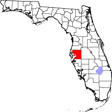 Location in the U.S. state of Florida | |||||
 Florida's location in the U.S. | |||||
| Founded | January 25, 1834 | ||||
| Named for | Wills Hill, Earl of Hillsborough | ||||
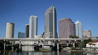
| Seat | Tampa | ||||
| Largest city | Tampa | ||||
| Area | |||||
| • Total | 1,266 sq mi (3,279 km2) | ||||
| • Land | 1,020 sq mi (2,642 km2) | ||||
| • Water | 246 sq mi (637 km2), 19.4% | ||||
| Population (est.) | |||||
| • (2017) | 1,408,566[1] | ||||
| • Density | 1,381/sq mi (533/km2) | ||||
| Congressional districts | 12th, 14th, 15th, 16th | ||||
| Time zone | Eastern: UTC−5/−4 | ||||
| Website |
www | ||||

Hillsborough County is a county in the U.S. state of Florida. In the 2010 census, the population was 1,229,226,[2] making it the fourth most populous county in Florida and the most populous county outside the Miami Metropolitan Area. A 2017 estimate has the population of Hillsborough County at 1,408,566 people,[3] which itself is greater than the populations of ten states according to their 2017 population estimates.[4] Its county seat and largest city is Tampa.[5]
Hillsborough County is part of the Tampa–St. Petersburg–Clearwater, FL Metropolitan Statistical Area.
History
Hillsborough County was created on January 25, 1834, from Alachua and Monroe counties,[6] during the U.S. territorial period (1822–1845). The new county was named for Wills Hill, the Earl of Hillsborough, who served as British Secretary of State for the Colonies from 1768 to 1772.[7] The County was created through efforts by Augustus Steele.[8]
The county's 1834 area was much larger and included eight other present-day counties: Charlotte County, DeSoto, Hardee, Manatee, Pasco, Pinellas, Polk, and Sarasota.[9]
The last significant change in Hillsborough County's borders was the separation of its western section to create Pinellas County, in 1911.
On New Year's Day in 1914, the St. Petersburg-Tampa Airboat Line initiated the first scheduled commercial airline service in the world, from St. Petersburg to Tampa.[10]
Geography
 On the Alafia River near Lithia Springs Park
 An alligator in the Alafia River State Park
 Hurrah Lake on the Alafia River
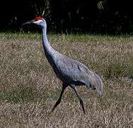
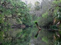 On the Hillsborough River near Lettuce Lake Park
According to the U.S. Census Bureau, the county has a total area of 1,266 square miles (3,280 km2), of which 1,020 square miles (2,600 km2) is land and 246 square miles (640 km2) (19.4%) is water.[11] There is approximately 158.27 miles (254.71 km) of shoreline on Tampa Bay.
The county's unincorporated area is approximately 888 square miles (2,300 km2), more than 84 percent of the total land area. Municipalities account for 163 square miles (420 km2). The modern boundaries of the county place it midway along the west coast of Florida.
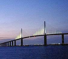
A narrow portion of Hillsborough County to the south, consisting almost exclusively of water, extends west to the Gulf of Mexico roughly along the Tampa Port Shipping Channel. This has the effect of keeping Hillsborough County from being technically landlocked. The central portion of the Sunshine Skyway Bridge is in Hillsborough County. So is Egmont Key, at the entrance to Tampa Bay; this narrow strip of land separates Pinellas County from Manatee County. The northernmost tip of a spoil island just west of Port Manatee also lies in Hillsborough County.

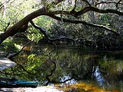
Hillsborough is home to Alafia River State Park and Hillsborough River state parks, and to the C. W. Bill Young Regional Reservoir and Lithia Springs, one of the largest natural springs in Florida.
Adjacent counties
- Pasco County, Florida: north
- Polk County, Florida: east
- Hardee County, Florida: southeast
- Manatee County, Florida: south
- Pinellas County, Florida: west
Demographics
| Historical population | |||
|---|---|---|---|
| Census | Pop. | %± | |
| 1840 | 452 | — | |
| 1850 | 2,377 | 425.9% | |
| 1860 | 2,981 | 25.4% | |
| 1870 | 3,216 | 7.9% | |
| 1880 | 5,814 | 80.8% | |
| 1890 | 14,941 | 157.0% | |
| 1900 | 36,013 | 141.0% | |
| 1910 | 78,374 | 117.6% | |
| 1920 | 88,257 | 12.6% | |
| 1930 | 153,519 | 73.9% | |
| 1940 | 180,148 | 17.3% | |
| 1950 | 249,894 | 38.7% | |
| 1960 | 397,788 | 59.2% | |
| 1970 | 490,265 | 23.2% | |
| 1980 | 646,960 | 32.0% | |
| 1990 | 834,054 | 28.9% | |
| 2000 | 998,948 | 19.8% | |
| 2010 | 1,229,226 | 23.1% | |
| Est. 2017 | 1,408,566 | [12] | 14.6% |
| U.S. Decennial Census[13] 1790-1960[14] 1900-1990[15] 1990-2000[16] 2010-2015[2] | |||
2010 Census
U.S. Census Bureau 2010 Ethnic/Race Demographics:[17][18]
- White (non-Hispanic) (71.3% when including White Hispanics): 53.7% (12.1% German, 11.0% Irish, 8.9% English, 6.7% Italian, 2.6% French, 2.4% Polish, 1.9% Scottish, 1.6% Scotch-Irish, 1.3% Dutch, 0.8% Russian, 0.8% Swedish, 0.7% Welsh, 0.6% French Canadian, 0.6% Norwegian, 0.5% Hungarian, 0.5% Greek)[17]
- Black (non-Hispanic) (16.7% when including Black Hispanics): 15.6% (2.4% West Indian/Afro-Caribbean American [0.7% Jamaican, 0.6% Haitian, 0.5% Other or Unspecified West Indian, 0.1% Trinidadian and Tobagonian, 0.1% British West Indian, 0.1% U.S. Virgin Islander] 0.9% Subsaharan African)[17][19]
- Hispanic or Latino of any race: 24.9% (7.4% Puerto Rican, 5.3% Cuban, 5.3% Mexican, 1.2% Colombian, 1.1% Dominican, 0.7% Spaniard, 0.5% Honduran)[17][20]
- Asian: 3.4% (1.2% Indian, 0.5% Vietnamese, 0.5% Filipino, 0.4% Chinese, 0.4% Other Asian, 0.3% Korean, 0.1% Japanese)[17][18]
- Two or more races: 3.1%
- American Indian and Alaska Native: 0.4%
- Native Hawaiian and Other Pacific Islander: 0.1%[17][18]
- Other Races: 5.0% (0.6% Arab)[17]
In 2010, 6.0% of the Hillsborough's population considered themselves to be of only "American" ancestry (regardless of race or ethnicity.)[17]
There were 536,092 households out of which 29.74% had children under the age of 18 living with them, 44.25% were married couples living together, 14.76% had a female householder with no husband present, and 35.69% were non-families. 27.12% of all households were made up of individuals and 7.96% (2.35% male and 5.61% female) had someone living alone who was 65 years of age or older. The average household size was 2.55 and the average family size was 3.11.[21][22]
The age distribution was as follows: 23.9% were under the age of 18, 10.5% from 18 to 24, 28.3% from 25 to 44, 25.4% from 45 to 64, and 11.8% were 65 years of age or older. The median age was 36.1 years. For every 100 females there were 95.1 males. For every 100 females age 18 and over, there were 92.1 males.[21][22]
The median income for a household in the county was $49,536, and the median income for a family was $59,886. Males had a median income of $43,125 versus $35,184 for females. The per capita income for the county was $27,062. About 10.7% of families and 14.2% of the population were below the poverty line, including 19.9% of those under age 18 and 9.6% of those aged 65 or over.[23]
In 2010, 15.1% of the county's population was foreign born, with 44.5% being naturalized American citizens. Of foreign-born residents, 67.5% were born in Latin America, 16.7% born in Asia, 9.2% were born in Europe, 3.2% born in Africa, 3.1% in North America, and 0.3% were born in Oceania.
2000 Census
As of the census of 2000, there were 998,948 people, 391,357 households, and 255,164 families residing in the county. The population density was 951 people per square mile (367/km²). There were 425,962 housing units at an average density of 405 per square mile (156/km²). The racial makeup of the county was 75.17% White (63.3% Non-Hispanic White),[24] 14.96% Black or African American, 0.39% Native American, 2.20% Asian, 0.07% Pacific Islander, 4.66% from other races, and a 2.56% from two or more races. 17.99% of the population were Hispanic or Latino of any race. The county was the thirty-second most populous county in the nation.
There were 391,357 households out of which 31.40% had children under the age of 18 living with them, 47.70% were married couples living together, 13.20% had a female householder with no husband present, and 34.80% were non-families. 26.90% of all households were made up of individuals and 8.10% had someone living alone who was 65 years of age or older. The average household size was 2.51 and the average family size was 3.07.
The age distribution was as follows: 25.30% were under the age of 18, 9.30% from 18 to 24, 31.70% from 25 to 44, 21.70% from 45 to 64, and 12.00% were 65 years of age or older. The median age was 35 years. For every 100 females there were 95.80 males. For every 100 females age 18 and over, there were 92.70 males.
The median income for a household in the county was $40,663, and the median income for a family was $48,223. Males had a median income of $34,111 versus $26,962 for females. The per capita income for the county was $21,812. About 9.10% of families and 12.50% of the population were below the poverty line, including 17.20% of those under age 18 and 10.00% of those age 65 or over.
| Level of Education | ||||
|---|---|---|---|---|
| Level | Hillsborough Co. | Florida | U.S. | |
| College/Associate Degree | 29.0% | 28.8% | 27.4% | |
| Bachelor's Degree | 16.7% | 14.3% | 15.5% | |
| Master's or Ph. D. | 8.4% | 8.1% | 8.9% | |
| Total | 54.1% | 51.2% | 51.8% | |
Source: U.S. Census[25]
Languages
As of 2010, 74.59% of the population spoke only English at home, 19.52% spoke Spanish, 0.56% French Creole (mainly Haitian Creole,) and 0.51% spoke Vietnamese as their mother language.[26] In total, 25.41% of the population spoke a language other than English as their primary language.[26]
Politics and government
Hillsborough County tends to lean Democratic, having not been won by a Republican presidential candidate since the 2004 election. However, for the last quarter-century, it has been a powerful swing county in one of the nation's most important swing states. It is part of the politically important I-4 Corridor between Tampa Bay and Orlando, an area that historically decides most elections in Florida. Hillsborough was considered a bellwether county, voting for the statewide winner in every presidential election from 1964-2012. It has also voted for the winner of the presidency in every election since 1928 except twice, voting for the loser only in 1992 and 2016.
In 2008, Barack Obama won the county by seven points, the first Democrat to capture the county since Bill Clinton's reelection victory in 1996.[27] Obama won Hillsborough again in 2012 over Republican presidential nominee Mitt Romney by roughly the same margin.
| Year | Republican | Democratic | Third parties |
|---|---|---|---|
| 2016 | 44.19% 266,870 | 50.99% 307,896 | 4.82% 29,124 |
| 2012 | 46.04% 250,186 | 52.71% 286,467 | 1.25% 6,776 |
| 2008 | 45.94% 236,355 | 53.05% 272,963 | 1.01% 5,183 |
| 2004 | 53.01% 245,576 | 46.23% 214,132 | 0.76% 3,514 |
| 2000 | 50.17% 180,794 | 47.06% 169,576 | 2.77% 9,984 |
| 1996 | 44.33% 136,656 | 46.80% 144,266 | 8.87% 27,349 |
| 1992 | 42.07% 130,643 | 37.13% 115,282 | 20.80% 64,577 |
| 1988 | 59.89% 150,151 | 39.49% 99,014 | 0.62% 1,551 |
| 1984 | 64.67% 157,926 | 35.31% 86,230 | 0.02% 52 |
| 1980 | 51.71% 106,160 | 42.99% 88,271 | 5.30% 10,883 |
| 1976 | 44.82% 78,504 | 54.01% 94,589 | 1.17% 2,052 |
| 1972 | 70.13% 106,956 | 29.71% 45,305 | 0.16% 249 |
| 1968 | 34.77% 49,441 | 32.24% 45,848 | 32.99% 46,913 |
| 1964 | 41.52% 50,616 | 58.48% 71,289 | |
| 1960 | 43.99% 48,887 | 56.01% 62,240 | |
| 1956 | 52.04% 41,889 | 47.96% 38,610 | |
| 1952 | 52.20% 36,316 | 47.80% 33,252 | |
| 1948 | 32.77% 13,529 | 45.67% 18,854 | 21.57% 8,903 |
| 1944 | 24.76% 10,252 | 75.24% 31,146 | |
| 1940 | 20.25% 7,805 | 79.75% 30,738 | |
| 1936 | 20.97% 5,361 | 79.03% 20,202 | |
| 1932 | 19.75% 4,711 | 80.25% 19,143 | |
| 1928 | 52.98% 11,703 | 45.24% 9,993 | 1.77% 392 |
| 1924 | 22.08% 1,585 | 62.26% 4,470 | 15.66% 1,125 |
| 1920 | 30.54% 3,772 | 56.49% 6,976 | 12.96% 1,601 |
| 1916 | 10.45% 691 | 69.95% 4,627 | 19.61% 1,297 |
| 1912 | 4.07% 159 | 67.63% 2,641 | 28.30% 1,105 |
| 1908 | 9.94% 367 | 73.17% 2,703 | 16.89% 624 |
| 1904 | 16.38% 516 | 62.71% 1,976 | 20.91% 659 |
A Home Rule Charter for Hillsborough County was approved by voters in a county-wide referendum held in September 1983, and the first County Commissioners elected under this new charter took office on May 28, 1985.
The Home Rule Charter divides the power of county government between legislative and executive branches. The Board of County Commissioners, which composes the legislative branch, sets overall policy by means of ordinances, resolutions and motions.
The executive powers of county government are vested in the County Administrator, appointed by County Commissioners and charged by the charter to faithfully implement the powers of the Board. The charter provides for a County Attorney, to be hired by the County Administrator with the advice and consent of the County Commissioners. The charter contains a provision for a Charter Review Board appointed by County Commissioners every five years to conduct a study of county government and propose amendments to the charter. These amendments must be presented to voters for approval. One amendment was approved in November 2002, adding the position of County Internal Performance Auditor to the government structure. This position reports directly to the County Commission.
There are seven members of the Board of County Commissioners for Hillsborough County. Four are elected from single-member districts, and three are elected county wide. The Board approves the County's operating and capital budgets and the County's capital improvement program. It may take action on any programs for the improvement of the county and the welfare of its residents.
Government Officials
There are also five countywide elected positions which have specific responsibilities under the county charter:
- Clerk of the Circuit Court: Pat Frank (D)
- Sheriff: Chad Chronister (R)
- Property Appraiser: Bob Henriquez (D)
- Tax Collector: Doug Belden (R)
- Supervisor of Elections: Craig Latimer (D)
Under a Charter Ordinance that went into effect May 1985, County Commissioners are directed to perform legislative functions of government by developing policy for the management of Hillsborough County. The County Administrator, a professional appointed by the Board, and the administrative staff are responsible for the implementation of these policies.
The Board also serves as the Environmental Protection Commission. Individual Board members serve on various other boards, authorities, and commissions such as the Hillsborough Area Regional Transit Authority, Tampa Bay Regional Planning Council, Tampa Bay Water, Aviation Authority, Expressway Authority, Sports Authority, Port Authority, Arts Council of Hillsborough County, Children's Board, Metropolitan Planning Organization and the Council of Governments.
Hillsborough County charges a discretionary sales tax of 1% on top of Florida's 6%. It is only collected on the first $5000 of any large purchase.
Voter Registration
Registration as of 7/11/2018.
| Political Party | Number of registered voters | Percentage | |
|---|---|---|---|
| Democratic | 322,472 | 38.78% | |
| Republican | 263,033 | 31.64% | |
| Others | 245,931 | 29.58% | |
| Total | 831,436 | 100% | |
Economy
In the early 20th century Hillsborough's economy was predominantly based on cigar making and agriculture. In 2012, Hillsborough had the second largest agricultural output among Florida's Counties. As of 2010, the average annual employment in Hillsborough County was 563,292. The percentages of total employment by industry was:
- Natural Resources & Mining 2.0%
- Construction 4.6%
- Manufacturing 4.1%
- Trade, Transportation and Utilities 19.5%
- Information 3.0%
- Financial Activities 9.2%
- Professional & Business Services 18.1%
- Education & Health Services 14.6%
- Leisure & Hospitality 10.3%
- Other Services 2.7%
- Public administration 4.7%
Agriculture
In 2011, sales of all agricultural commodities produced in Hillsborough County were over 832,410,300 dollars. The largest crop by value was strawberries at over 388 million dollars.[31] Values of various crops included:
| Crop | Sales in dollars | Acreage |
|---|---|---|
| Strawberries | $388,125,702 | 11,625 |
| Vegetables | $150,000,000 | 13,092 |
| Ornamental plants | $139,232,407 | 3,977 |
| Aquaculture | $23,546,112 | 876 |
| Beef cattle/pasture | $18,934,207 | 91,904 |
| Citrus | $18,893,572 | 10,750 |
| Poultry | $18,701,100 | 22 |
| Sod | $7,438,855 | 2,286 |
| Dairy | $6,433,206 | 1,500 |
| Blueberries | $5,500,000 | 591 |
| Hay | $2,374,195 | 635 |
| Forestry | $1,000,000 | 108,634 |
| Bees/honey | $598,767 | 45 |
| Goats | $154,177 | 518 |
| Miscellaneous | $51,478,000 | 3677 |
| Total | $832,410,300 | 255,532 |
List of companies with headquarters in Hillsborough County
- Ashley Global Retail, the parent of Ashley Furniture.[32]
- Beef O'Brady's
- Big Brothers Big Sisters of America
- Bloomin' Brands
- Checkers and Rally's
- International Softball Federation
- Lykes Brothers
- MisterCertified
- Mosaic's Phosphate Division
- Odyssey Marine Exploration
- Patterson Companies
- Rooms To Go
- Shriners International [33]
- Sweetbay Supermarkets (since absorbed by BI-LO's Winn-Dixie chain) had its headquarters in an unincorporated area in the county, near Tampa.[34]
- Sykes Enterprises
Education
Hillsborough County Public Schools operates public schools in the county. Hillsborough County has the eighth largest school district in the United States consisting of 206 schools (133 elementary schools, 42 middle schools, 2 K-8 schools, 27 traditional high schools and 4 career centers; 73 additional schools including charter, ESE, etc.).[35] In 2013, twelve out of Hillsborough County's 27 public high schools were ranked in Newsweek's list of America's Best High Schools.[36] In 2012 and 2013, all 27 public high schools were included on the Washington Post's list of the 2000 most challenging schools in America.[37]
School enrollment
- 1997–1998 149,658 3,151 increase
- 1998–1999 152,809 3,437 increase
- 1999–2000 156,246 4,500 increase
- 2000–2001 160,746 5,315 increase
- 2001–2002 166,061 5,261 increase
- 2002–2003 171,322 6,235 increase
- 2003–2004 177,557 7,113 increase
- 2004–2005 184,670 7,113 increase
- 2005–2006 190,835 6,165 increase
- 2006–2007 191,151 316 increase
- 2007–2008 191,219 68 increase (projected)
Source: Tampa Tribune
Museums and libraries
Museums
- Tampa Museum of Art in Tampa
- Florida Museum of Photographic Arts in Tampa
- Glazer Children’s Museum in Tampa
- Museum of Science & Industry (Tampa)
- Henry B. Plant Museum in Tampa
- Tampa Bay History Center in Tampa
Libraries
These libraries are part of the Hillsborough County Public Library Cooperative:
Law enforcement
Several local, state, and federal law enforcement agencies operate within Hillsborough County, Florida. They range in operations and jurisdictions from one agency to the next.
Federal agencies
- Federal Bureau of Investigation (FBI)
- Drug Enforcement Administration (DEA)
- Department of Alcohol, Tobacco, Firearms and Explosives (ATF)
- US Marshall's Service
- US Customs and Border Protection (CBP)
- Department of Homeland Security (DHS)
- Department of Defense
- US Immigration and Customs Enforcement (ICE)
- Military Police (on military bases or stations) (MP)
- Federal Bureau of Prisons (BOP)
- Veterans Administration Police (VAPD)
State Agencies
- Florida Department of Transportation (FDOT)
- Florida Department of Law Enforcement (FDLE)
- State Fire Marshall's Office
- Department of Corrections (COR)
- Florida Highway Patrol (FHP)
- Florida Fish and Wildlife Conservation Commission (FWC)
Local agencies
There are several agencies providing law enforcement to the residents of Hillsborough County. They are all accredited and fully certified law enforcement agencies by the FDLE.
|
Hillsborough County Sheriff's Office The HCSO is the largest local law enforcement agency in Hillsborough County. Headquartered in the Ybor City District of Tampa, it is responsible for Law Enforcement services in the unincorporated areas of the county. The county is divided into 4 districts, each containing multiple sectors identified with a letter (example: H - Hotel sector, G - Golf sector). The districts and sectors are cut to exclude areas covered by other local agencies. The School district uses two agencies for security. The Sheriff's office employs deputies assigned to various schools throughout the county. They, along with the Hillsborough County Public Schools Security Service officers are known as School Resource Officers. Generally, deputies are assigned to schools outside of the incorporated cities and HCPSSS officers are assigned to schools within city limits. For extended services, other local agencies may be called in for support. Most crossing guards are employed in a non-sworn capacity by the Sheriff's office. |
|
Plant City Police Department Plant City maintains its own police department and is the 3rd largest policing agency in terms of sworn officers following HCSO and TPD. The agency provides law enforcement services to the residents of Plant City and occasionally provides backup to HCSO answering calls close to their jurisdiction. |
|
Seminole Police Department The Seminole Indian Tribe operates the Hard Rock Hotel and Casino located in Tampa. The tribe has its own police department that operates on the grounds and at tribe events. They also respond to altercations that involves members of the tribe. |
|
Tampa Airport Police Department Tampa International Airport operates the Tampa Airport Police. They are a full service policing agency providing services to the airport and surrounding areas where services to the airport take place. |
|
Tampa Police Department The TPD is the second largest agency in the county. They service the City of Tampa, New Tampa, Port of Tampa, and other areas surrounding. |
|
Temple Terrace Police Department The city of Temple Terrace operates a police department with over 50 sworn officers. |
|
University of South Florida Police Department The USF Police department has jurisdiction throughout the grounds of USF and other facilities operated by the university. They provide services to anyone located on the property and have full policing authority granted by the Florida Department of Law Enforcement. |
|
County Jails and Courthouse Security The sheriff's office operates the only two county jail facilities and one work release center. The Falkenburg Road Jail is the larger of the two jails. Orient Road Jail was the first in the nation to utilize open-booking areas. With these being the only jails in the county, other than juvenile detention facilities, the work release center, or holding cells located at multiple police stations and sheriff offices, all local agencies transport persons being arrested to one of the county jails. The Sheriff's Office also provides security and protective services at the county courthouses in Tampa. With a majority of transportation of inmates to and from the courthouse being handled by the Sheriff's office, the inmates remain in the custody of HCSO during the duration of the process until handed over to another jurisdiction, state, or federal custody. |
|
Auxiliary and Reserve officers Some of these agencies also have auxiliary (reserve) deputies, officers, or troopers (here-in known as officer). They are volunteer (un-paid) citizens and generally sworn positions with a lesser certification that requires assignment to a fully certified officer to exercise. Some auxiliary officers are fully certified law enforcement officers by the state and are permitted by the hosting agency to operate without assignment to a fully certified officer. The services they provide to the community are equal to that of a full service officer and each agency sets forth how much service time is required to maintain status as an auxiliary officer. As of March 2016 the following agencies have auxiliary or reserve deputy, officer, or trooper positions.
|
|
Special Events During special events, multiple agencies provide off duty officers for security and support. They work hand in hand with the agency within whose jurisdiction the event is taking place. For example, college football games held at Raymond James Stadium are served primarily by TPD and FHP. Other agencies may also support the event. |
Hillsborough County Fire Rescue
Hillsborough County Fire Rescue services the unincorporated areas of Hillsborough County. Fire service began in the 1950s as an all volunteer force consisting of about a dozen loosely associated community-based organizations. The first full-time career firefighters were hired in 1973. The department now has 1,019 career uniformed and support personnel which continue to set the pace in Fire and Emergency Medical Response making it the third largest department in the state. Since the 1997 consolidation of Hillsborough County Fire Rescue and Emergency Medical Services (EMS), the department has placed paramedics on each career, front-line apparatus: 28 Rescues, 42 Engines, 4 Ladder Trucks and 4 Special Operations Units operating out of 43 Fire Stations throughout Unincorporated Hillsborough County. As nearly 85% of the department's more than 90,000 emergency responses require some level of medical care, having paramedics assigned to each unit assures that the citizens of Hillsborough County are receiving rapid Advanced Life Support care.
Hillsborough County Fire Rescue and the Board of County Commissioners has implemented a plan to continue placing new fire rescue stations in areas where growth is occurring or gaps in coverage may exist. Fire Chief Dennis Jones leads a Senior Staff of two Deputy Chiefs (Operations and Administrative branches), the Fire Marshal and the Emergency Manager. All fiscal functions, facilities maintenance and supply, apparatus/equipment procurement, Emergency Dispatch Manager, Personnel Chief, and Training Chief are under the direction of the Deputy Chief of Administration. The three Shift Commanders, as well as the Rescue Chief and the Special Operations Chief, report directly to the Deputy Chief of Operations. The Operations Chief is responsible for the overall response readiness of all front line personnel. The Emergency Manager oversees all Office of Emergency Management (OEM) planning and operations of the EOC.[38]
Hillsborough County Fire Rescue Office of Emergency Management
The Office of Emergency Management is a division of Hillsborough County Fire Rescue that is directly responsible for planning and coordinating the evacuation and sheltering of all county residents in the event of a natural or manmade disaster. This agency is also responsible for planning, orchestrating and coordinating response actions and continuity of government in the aftermath of a major disaster. Preston Cook has been the Emergency Manager since 2011
The Hurricane Evacuation Assessment Tool (HEAT) has been created to assist residents of Hillsborough County by providing evacuation and sheltering information in the event of a hurricane or other natural disaster. This interactive program was designed to assist the public in easily determining if they are in one of the five evacuation zones. It also provides information on shelters, hospitals, fire stations and sandbag locations.
The Office of Emergency Management also provides information to the public on the following: Hurricane Information, Procedures for Hazardous Materials Spills, Flooding Preparedness, Tornado Preparedness, Wildfire Preparedness, and Terrorism Preparedness.
Transportation

Airports
The county's primary commercial aviation airport is Tampa International Airport in Tampa. Other important airports include the Tampa Executive Airport near Brandon, Peter O. Knight Airport near Downtown Tampa, and the Plant City Airport near Plant City.
Major highways
| Interstate Highways | U.S Routes | State Routes |
Public surface transportation
Hillsborough County is served by Hillsborough Area Regional Transit buses.
Nationally-protected areas
Parks
- Alafia River Corridor Preserve
- Alderman's Ford Regional Park
- Balm-Boyette Scrub Nature Preserve
- Bell Creek Nature Preserve
- Blackwater Creek Preserve
- Brooker Creek Headwaters Nature Preserve
- Chito Branch Reserve
- Cockroach Bay Aquatic Preserve
- Edward Medard Park and Reservoir
- Fish Hawk Creek Preserve
- Hillsborough River State Park
- Lake Rogers Park
- Lettuce Lake Park
- Lithia Springs Regional Park
- Little Manatee River State Park
- Lower Green Swamp Preserve
- McKay Bay Nature Park
- Schultz Preserve
- Skyway Fishing Pier State Park
- Upper Tampa Bay Park
- Upper Tampa Bay Trail
- Wolf Branch Nature Preserve
Communities
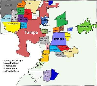
Cities
There are only three cities incorporated in Hillsborough County.
Census-designated places
Despite its large population most of the area of the county is unincorporated and falls under the jurisdiction of the Hillsborough county board of Commissioners.[39]
- Apollo Beach
- Balm
- Bloomingdale
- Boyette (former, now part of Riverview CDP)
- Brandon
- Carrollwood
- Cheval
- Citrus Park
- Dover
- East Lake-Orient Park
- Egypt Lake-Leto
- Fish Hawk
- Gibsonton
- Keystone
- Lake Magdalene
- Lutz
- Mango
- Northdale
- Palm River-Clair Mel
- Pebble Creek
- Progress Village
- Riverview
- Ruskin
- Seffner
- Sun City Center
- Thonotosassa
- Town 'n' Country
- University
- Valrico
- Westchase
- Wimauma
Unincorporated communities
- Adamsville
- Alafia
- Antioch
- Bay Crest Park
- Clair-Mel City
- Del Rio
- Durant
- East Lake
- East Tampa
- Egypt Lake
- Fort Lonesome
- Gulf City
- Hopewell
- Keysville
- Knights[40]
- Lake Fern
- Leto
- Limona
- Lithia
- Nowatney
- Orient Park
- Palma Ceia
- Palm River
- Picnic
- Pinecrest
- Port Sutton
- Rattlesnake
- Remlap
- Rocky Creek
- Snows Corner
- Sulphur Springs
- Sun City Center
- Sweetwater Creek
- Sydney
- Trapnell
- Turkey Creek[41]
Historic towns
- Bullfrog Corner
- Bone Valley
- Branchton
- Callsville
- Chataocolea
- Chicora
- Clarkwild
- Coronet
- Cork (now Dover, not to be confused with two other places named Cork)
- Cork (now Plant City)
- Cosme
- Dillon
- Diston
- Drew Park, absorbed by Tampa
- East Cove
- Edeson
- Flora
- Fort Brooke
- Fort Foster
- Fort Sullivan
- Gardenville
- Gary
- Gulf City
- Harney
- Hillsboro
- Ichipucksassa, aka Ichepucksassa, Hitchipucksassa (now Plant City)
- Idlewild Park
- Jackson Springs
- Keystone Park
- Knights Station
- Knowles
- Lake Fern
- Lighthall
- Lillibridge
- Magdalene
- Magnolia
- Mangrove Point
- Manhattan (absorbed by Tampa)
- Marvinia
- Midway
- Mullins City
- Nicholls
- Oliphant
- Orient
- Peck
- Pelot
- Peru
- Prairie
- Riverhead
- Rocky Point
- Sparkman
- Stemper
- St Helena
- Trapnell (absorbed by Plant City)
- Welcome
- Weldon
- Willow
- Youmans[42]
See also
- Hillsborough County Sheriff's Office
- Hillsborough County Public Schools
- National Register of Historic Places listings in Hillsborough County, Florida
- USS Hillsborough County (LST-827)
- Upper Tampa Bay Park
- List of schools in Hillsborough County, Florida
- List of counties in Florida
- List of tallest buildings in Tampa
References
- ↑ "American FactFinder". census.gov. Archived from the original on July 11, 2011.
- 1 2 "State & County QuickFacts". United States Census Bureau. Archived from the original on July 11, 2011. Retrieved June 14, 2014.
- ↑ "Population and Housing Unit Estimates". Retrieved June 9, 2017.
- ↑ "American FactFinder" (XLSX). United States Census Bureau. Retrieved March 24, 2018.
- ↑ "Find a County". National Association of Counties. Archived from the original on May 31, 2011. Retrieved June 7, 2011.
- ↑ "Hillsborough County Census". skcensus.com. Archived from the original on June 26, 2006.
- ↑ Publications of the Florida Historical Society. Florida Historical Society. 1908. p. 31.
- ↑ McCarthy, Kevin (2011-01-01). Hillsborough River Guidebook. Pineapple Press Inc. ISBN 9781561644872.
- ↑ Florida Center for Instructional Technology. "Exploring Florida Hillsborough County Maps". usf.edu.
- ↑ "World's First Commercial Airline - The Greatest Moments in Flight". Space.com.
- ↑ "US Gazetteer files: 2010, 2000, and 1990". United States Census Bureau. February 12, 2011. Retrieved April 23, 2011.
- ↑ "American FactFinder". Retrieved March 24, 2018.
- ↑ "U.S. Decennial Census". United States Census Bureau. Archived from the original on May 12, 2015. Retrieved June 14, 2014.
- ↑ "Historical Census Browser". University of Virginia Library. Retrieved June 14, 2014.
- ↑ "Population of Counties by Decennial Census: 1900 to 1990". United States Census Bureau. Retrieved June 14, 2014.
- ↑ "Census 2000 PHC-T-4. Ranking Tables for Counties: 1990 and 2000" (PDF). United States Census Bureau. Retrieved June 14, 2014.
- 1 2 3 4 5 6 7 8 "Hillsborough County: Selected Social Characteristics in the United States 2006-2010 American Community Survey 5-Year Estimates". factfinder.census.gov. Retrieved October 20, 2015.
- 1 2 3 "Hillsborough County Demographic Characteristics". ocala.com. Retrieved October 20, 2015.
- ↑ "Hillsborough County, Florida First Ancestry Reported Universe: Total population - 2006-2010 American Community Survey 5-Year Estimates". factfinder.census.gov. Retrieved November 12, 2015.
- ↑ "Hispanic or Latino by Type: 2010 -- 2010 Census Summary File 1". factfinder.census.gov. Retrieved October 19, 2015.
- 1 2 "Hillsborough County: Age Groups and Sex: 2010 - 2010 Census Summary File 1". factfinder.census.gov. Retrieved October 20, 2015.
- 1 2 "Hillsborough County: Age Groups and Sex: 2010 - 2010 Census Summary File 1". censusviewer.com. Retrieved October 20, 2015.
- ↑ "Hillsborough County, Florida: SELECTED ECONOMIC CHARACTERISTICS - 2006-2010 American Community Survey 5-Year Estimates". factfinder.census.gov. Archived from the original on November 29, 2014. Retrieved November 18, 2015.
- ↑ "Demographics of Hillsborough County, FL". MuniNetGuide.com. Archived from the original on November 15, 2006. Retrieved October 20, 2015.
- ↑ 2004 U.S. Census
- 1 2 "Modern Language Association Data Center Results of Miami-Dade County, Florida". Modern Language Association. Retrieved October 20, 2015.
- ↑ David Leip. "2004 Presidential General Election Results - Florida". uselectionatlas.org.
- ↑ Leip, David. "Dave Leip's Atlas of U.S. Presidential Elections". uselectionatlas.org. Retrieved 2018-06-15.
- ↑ "Hillsborough County Supervisor of Elections".
- ↑ http://www.eflorida.com/profiles/CountyReport.asp?CountyID=54&Display=all
- ↑ http://www.hillsboroughcounty.org/DocumentCenter/View/6140
- ↑ http://www.ashleyfurniture.com/company/tampa-office
- ↑ "Contact Us - Shriners International". www.shrinersinternational.org. Retrieved 2018-07-11.
- ↑ "Contacts Archived May 22, 2012, at the Wayback Machine.." Delhaize Group. Retrieved on May 17, 2012. "Sweetbay Supermarkets, 3801 Sugar Palm Drive Tampa – FL 33619 - U.S.A."
- ↑ Hillsborough County Public Schools Archived March 4, 2007, at the Wayback Machine.
- ↑ America's Best High Schools
- ↑ "National Schools". washingtonpost.com.
- ↑ Hillsborough Fire Rescue Summary Archived June 24, 2008, at the Wayback Machine.
- ↑ "Hillsborough County, FL - Official Website - Board of County Commissioners". hillsboroughcounty.org.
- ↑ http://www.hillsborough.communityatlas.usf.edu/upload/documents/HILLSBOROUGH_COUNTY_Historic_Resources_Excerpts_Knights.pdf
- ↑ http://www.hillsborough.communityatlas.usf.edu/upload/documents/HILLSBOROUGH_COUNTY_Historic_Resources_Excerpts_Turkey%20Creek.pdf
- ↑ Florida Center for Instructional Technology. "Florida Maps - Hillsborough County". usf.edu.
External links
| Wikimedia Commons has media related to Hillsborough County, Florida. |
Places adjacent to Hillsborough County, Florida | ||||||||||
|---|---|---|---|---|---|---|---|---|---|---|
| ||||||||||